Cernobbio Cernòbi (Lombard) | ||
---|---|---|
Comune | ||
Città di Cernobbio | ||
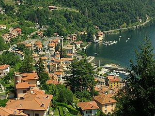
Panorama of Cernobbio | ||
| ||
Coordinates: 45°50′N9°4′E / 45.833°N 9.067°E Coordinates: 45°50′N9°4′E / 45.833°N 9.067°E | ||
Country | Italy | |
Region | Lombardy | |
Province | Province of Como (CO) | |
Frazioni | Piazza Santo Stefano, Rovenna, Casnedo, Gentrino, Madrona, Mornello, Olzino, Stimianico, Toldino | |
Government | ||
• Mayor | Paolo Furgoni | |
Area | ||
• Total | 11.7 km2 (4.5 sq mi) | |
Elevation | 202 m (663 ft) | |
Population (31 December 2010) [1] | ||
• Total | 7,059 | |
• Density | 600/km2 (1,600/sq mi) | |
Demonym(s) | Cernobbiesi | |
Time zone | CET (UTC+1) | |
• Summer (DST) | CEST (UTC+2) | |
Postal code | 22012 | |
Dialing code | 031 | |
Website | Official website |
Cernobbio (Comasco: Cernòbi [tʃerˈnɔbi] ) is a comune (municipality) in the province of Como, Lombardy, northern Italy. It is located about 40 kilometres (25 mi) north of Milan and about 2 kilometres (1 mi) northwest of Como, on the border with Switzerland and near the Lake Como. The highest peak is the Monte Bisbino, at 1,325 metres (4,347 ft).
The comune is a basic administrative division in Italy, roughly equivalent to a township or municipality.
The Province of Como is a province in the north of the Lombardy region of Italy and borders the Swiss cantons of Ticino and Grigioni to the North, the Italian provinces of Sondrio and Lecco to the East, the Province of Monza and Brianza to the south and the Province of Varese to the West. The city of Como is its capital — other large towns, with more than 10,000 inhabitants, include Cantù, Erba, Mariano Comense and Olgiate Comasco. Campione d'Italia also belongs to the province and is enclaved in the Swiss canton of Ticino.
Lombardy is one of the twenty administrative regions of Italy, in the northwest of the country, with an area of 23,844 square kilometres (9,206 sq mi). About 10 million people, forming one-sixth of Italy's population, live in Lombardy and about a fifth of Italy's GDP is produced in the region, making it the most populous and richest region in the country and one of the richest regions in Europe. Milan, Lombardy's capital, is the second-largest city and the largest metropolitan area in Italy.
Cernobbio borders the following municipalities: Blevio, Breggia (Switzerland), Como, Maslianico, Moltrasio, Vacallo (Switzerland).
Blevio is a comune (municipality) in the Province of Como in the Italian region Lombardy, located about 40 kilometres (25 mi) north of Milan and about 2 kilometres (1 mi) northeast of Como. It overlooks the eastern shore of Lake Como from hilly slopes starting at more than 200 metres (660 ft).
Como is a city and comune in Lombardy, Italy. It is the administrative capital of the Province of Como.
Maslianico is a comune (municipality) in the Province of Como in the Italian region Lombardy, located about 45 kilometres (28 mi) north of Milan and about 5 kilometres (3 mi) northwest of Como, on the border with Switzerland. As of 31 December 2004, it had a population of 3,469 and an area of 1.3 km².
Cernobbio received the honorary title of city with a presidential decree on May 24, 2005.
Since 1975, every year in early September the city of Cernobbio hosts the Ambrosetti Forum, an international economic conference.
The Ambrosetti Forum organized by The European House – Ambrosetti, a consulting firm – is an annual international economic conference held at Villa d'Este, in the Italian town of Cernobbio on the shores of Lake Como. Since its inception in 1975, the Forum has brought together heads of state, ministers, Nobel laureates and businesspeople to discuss current challenges to the world's economies and societies.
Cernobbio is a stopping point on the bus and ferry services that link Como to Colico via the west side of Lake Como. It is the starting point for the long-distance footpath, La Via dei Monti Lariani .
Colico is a city in the province of Lecco, Lombardy, Italy. It is situated on the northern arm of Lake Como, where the river Adda enters the lake. Colico is the most important city in the northern part of Lake Como, which is often identified as its Colico branch.
La Via dei Monti Lariani is a long-distance footpath in the hills on the west side of Lake Como, in Lombardy, Italy. Its total length is approximately 125 km, and its average altitude is about 1000 m, compared with the approximately 200 m of the lake shore. The trail starts in Cernobbio, just north-west of the city of Como, and ends at Sorico, at the northern extreme of the lake. The trail is conventionally divided into four numbered sections, each with different waymarking, but these do not correspond to days of walking; Sections 1-3 would each involve at least two days' walking for a normally fit person, while the fourth section is itself divided into two sections each of which could well require more than a single day. The path runs through a mixture of forest and pasture land, frequently offering magnificent views over the lake.
Argegno is a comune (municipality) in the Province of Como in the Italian region Lombardy, located about 50 kilometres (31 mi) north of Milan and about 15 kilometres (9 mi) north of Como. As of 31 December 2004, it had a population of 650 and an area of 4.3 square kilometres (1.7 sq mi).
Bizzarone is a comune (municipality) in the Province of Como in the Italian region Lombardy, located about 45 kilometres (28 mi) northwest of Milan and about 11 kilometres (7 mi) west of Como, on the border with Switzerland.
Cavargna is a comune (municipality) in the Province of Como in the Italian region Lombardy, located about 70 kilometres (43 mi) north of Milan and about 30 kilometres (19 mi) north of Como, on the border with Switzerland. As of 31 December 2004, it had a population of 296 and an area of 15.1 square kilometres (5.8 sq mi).
Cerano d'Intelvi is a comune (municipality) in the Province of Como in the Italian region Lombardy, located about 50 kilometres (31 mi) north of Milan and about 15 kilometres (9 mi) north of Como, on the border with Switzerland.
Domaso is a comune (municipality) in the Province of Como in the Italian region Lombardy, located about 80 kilometres (50 mi) north of Milan and about 40 kilometres (25 mi) northeast of Como. As of 9 October 2011, it had a population of 1,455 and an area of 6.1 km².
Dosso del Liro is a comune (municipality) in the Province of Como in the Italian region Lombardy, located about 80 kilometres (50 mi) north of Milan and about 40 kilometres (25 mi) northeast of Como, on the border with Switzerland. As of 31 December 2004, it had a population of 297 and an area of 23.2 km².
Grandate is a comune (municipality) in the Province of Como in the Italian region Lombardy, located about 35 kilometres (22 mi) north of Milan and about 4 kilometres (2 mi) southwest of Como.
Griante is a comune (municipality) in the Province of Como in the Italian region Lombardy, located on the western shore of Lake Como about 25 kilometres (16 mi) northeast of Como between Menaggio and Tremezzo. Griante also borders the communes of Bellagio and Varenna on the other side of the lake. The commune of Griante itself is situated some 50 metres above lake level, on a wide plateau. The portion of the commune sitting on the lake, where the community's tourist industry is situated, is known as Cadenabbia di Griante.
Moltrasio is a comune (municipality) in the Province of Como in the Italian region Lombardy, located about 45 kilometres (28 mi) north of Milan and about 6 kilometres (4 mi) north of Como, near the border with Switzerland, on the western shore of Lake Como.
Montano Lucino is a comune (municipality) in the Province of Como in the Italian region Lombardy, located about 35 kilometres (22 mi) north of Milan and about 5 km southwest of Como.
Rodero is a comune (municipality) in the Province of Como in the Italian region Lombardy, located about 45 kilometres (28 mi) northwest of Milan and about 13 kilometres (8 mi) west of Como, on the border with Switzerland.
Ronago is a comune (municipality) in the Province of Como in the Italian region Lombardy, located about 45 kilometres (28 mi) northwest of Milan and about 8 kilometres (5 mi) west of Como, on the border with Switzerland.
Schignano is a comune (municipality) in the Province of Como in the Italian region Lombardy, located about 50 kilometres (31 mi) north of Milan and about 13 kilometres (8 mi) north of Como, on the border with Switzerland.
Sorico is a comune (municipality) in the Province of Como in the Italian region Lombardy, located about 80 kilometres (50 mi) north of Milan and about 45 kilometres (28 mi) northeast of Como. As of 31 December 2004, it had a population of 1,188 and an area of 23.3 square kilometres (9.0 sq mi).
Val Rezzo is a comune (municipality) in the Province of Como in the Italian region Lombardy, located about 70 kilometres (43 mi) north of Milan and about 30 kilometres (19 mi) north of Como, on the border with Switzerland. As of 31 December 2004, it had a population of 202 and an area of 6.6 square kilometres (2.5 sq mi).
Valsolda is a comune (municipality) of about 1,400 inhabitants in the Province of Como in the Italian region Lombardy on the border with Switzerland. It is located about 60 kilometres (37 mi) north of Milan, about 25 kilometres (16 mi) north of Como and 2 kilometres (1.2 mi) east of Lugano.
Villa Guardia is a comune (municipality) in the Province of Como in the Italian region Lombardy, located about 35 kilometres (22 mi) northwest of Milan and about 6 kilometres (4 mi) southwest of Como.
Malgrate is a comune (municipality) in the Province of Lecco, in the Italian region Lombardy. Malgrate is located across from Lecco, from which it is geographically divided by the Lake Como. According to 31 December 2004 demographic data, has a population of 4,233 in an area of 2.0 square kilometres (0.77 sq mi).It Is about 45 kilometres (28 mi) northeast from Milan, the main city in Northern Italy.
This article on a location in the Province of Como is a stub. You can help Wikipedia by expanding it. |