Valbrona is a comune (municipality) in the Province of Como in the Italian region Lombardy, located about 45 kilometres (28 mi) north of Milan and about 20 kilometres (12 mi) northeast of Como. As of 31 December 2004, it had a population of 2,575 and an area of 13.9 square kilometres (5.4 sq mi).

Calco is a comune (municipality) in the Province of Lecco in the Italian region Lombardy, located about 35 kilometres (22 mi) northeast of Milan and about 15 kilometres (9 mi) south of Lecco. As of 31 December 2004, it had a population of 4,284 and an area of 4.6 square kilometres (1.8 sq mi).
Carenno is a comune (municipality) in the Province of Lecco in the Italian region Lombardy, located about 45 kilometres (28 mi) northeast of Milan and about 8 kilometres (5 mi) southeast of Lecco. As of 31 December 2004, it had a population of 1,476 and an area of 7.9 square kilometres (3.1 sq mi).
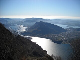
Civate is a comune (municipality) in the Province of Lecco in the Italian region Lombardy, located about 45 kilometres (28 mi) northeast of Milan and about 4 kilometres (2 mi) southwest of Lecco. As of 31 December 2004, it had a population of 3,898 and an area of 9.1 square kilometres (3.5 sq mi). Lago di Annone is located on its borders.
Dolzago is a comune (municipality) in the Province of Lecco in the Italian region Lombardy, located about 35 kilometres (22 mi) northeast of Milan and about 11 kilometres (6.8 mi) southwest of Lecco. As of 31 December 2004, it had a population of 2,126 and an area of 2.2 square kilometres (0.85 sq mi).
Ello is a comune (municipality) in the Province of Lecco in the Italian region Lombardy, located about 40 kilometres (25 mi) northeast of Milan and about 8 kilometres (5 mi) southwest of Lecco. As of 31 December 2004, it had a population of 1,202 and an area of 2.4 square kilometres (0.93 sq mi).
Erve is a comune (municipality) in the Province of Lecco in the Italian region Lombardy, located about 45 kilometres (28 mi) northeast of Milan and about 5 kilometres (3 mi) southeast of Lecco. As of 31 December 2004, it had a population of 758 and an area of 6.2 square kilometres (2.4 sq mi).
Galbiate is a comune (municipality) in the Province of Lecco in the Italian region Lombardy, located about 40 kilometres (25 mi) northeast of Milan and about 6 kilometres (4 mi) south of Lecco.
Garbagnate Monastero is a comune (municipality) in the Province of Lecco in the Italian region Lombardy, located about 35 kilometres (22 mi) northeast of Milan and about 12 kilometres (7 mi) southwest of Lecco. Garbagnate Monastero borders the following municipalities: Barzago, Bulciago, Costa Masnaga, Molteno, Sirone.
Garlate is a comune (municipality) in the Province of Lecco in the Italian region Lombardy, located about 40 kilometres (25 mi) northeast of Milan and about 6 kilometres (4 mi) south of Lecco. As of 31 December 2004, it had a population of 2,630 and an area of 2.1 square kilometres (0.81 sq mi).
Lomagna is a comune (municipality) in the Province of Lecco in the Italian region Lombardy, located about 25 kilometres (16 mi) northeast of Milan and about 20 kilometres (12 mi) south of Lecco.
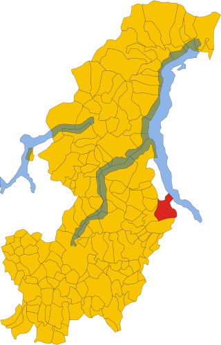
Malgrate is a comune (municipality) in the Province of Lecco, in the Italian region Lombardy. Malgrate is located across from Lecco, from which it is geographically divided by the Lake Como. According to 31 December 2004 demographic data, has a population of 4,233 in an area of 2.0 square kilometres (0.77 sq mi).It Is about 45 kilometres (28 mi) northeast from Milan, the main city in Northern Italy.
Montevecchia is a comune (municipality) in the Province of Lecco in the Italian region Lombardy, located about 30 kilometres (19 mi) northeast of Milan and about 15 kilometres (9 mi) south of Lecco. As of 31 December 2004, it had a population of 2,477 and an area of 5.9 square kilometres (2.3 sq mi).

Olginate is a comune (municipality) in the Province of Lecco in the Italian region Lombardy, located about 40 kilometres (25 mi) northeast of Milan and about 6 kilometres (4 mi) south of Lecco. As of October 2010, it had a population of 7,200 and an area of 7.9 square kilometres (3.1 sq mi).
Pasturo is a comune (municipality) in the Province of Lecco in the Italian region Lombardy, located about 60 kilometres (37 mi) northeast of Milan and about 11 kilometres (7 mi) north of Lecco. As of 31 December 2004, it had a population of 1,798 and an area of 22.1 square kilometres (8.5 sq mi).

Perledo is a comune (municipality) in the Province of Lecco in the Italian region Lombardy, located about 60 kilometres (37 mi) north of Milan and about 20 kilometres (12 mi) northwest of Lecco. As of 31 December 2004, it had a population of 900 and an area of 12.5 square kilometres (4.8 sq mi).

Pescate is a comune (municipality) in the Province of Lecco in the Italian region Lombardy, located about 45 kilometres (28 mi) northeast of Milan and about 2 kilometres (1 mi) south of Lecco. As of 31 December 2004, it had a population of 2,120 and an area of 2.1 square kilometres (0.81 sq mi).
Sirone is a comune (municipality) in the Province of Lecco in the Italian region Lombardy, located about 35 kilometres (22 mi) northeast of Milan and about 11 kilometres (7 mi) southwest of Lecco. As of 31 December 2004, it had a population of 2,270 and an area of 3.2 square kilometres (1.2 sq mi).
Sirtori is a comune (municipality) in the Province of Lecco in the Italian region Lombardy, located about 35 kilometres (22 mi) northeast of Milan and about 13 kilometres (8 mi) southwest of Lecco. As of 31 December 2004, it had a population of 2,844 and an area of 4.3 square kilometres (1.7 sq mi).
Viganò is a comune (municipality) in the Province of Lecco in the Italian region Lombardy, located about 30 kilometres (19 mi) northeast of Milan and about 15 kilometres (9 mi) southwest of Lecco. As of 31 December 2004, it had a population of 1,804 and an area of 1.6 square kilometres (0.62 sq mi).


