Pescate

Last updated
Pescate
Pescàa  (Lombard)
Comune
Comune di Pescate
Pescate.JPG
Pescate
Italy provincial location map 2015.svg
Red pog.svg
Pescate
Location of Pescate in Italy
Coordinates: 45°50′N9°24′E / 45.833°N 9.400°E / 45.833; 9.400 Coordinates: 45°50′N9°24′E / 45.833°N 9.400°E / 45.833; 9.400
Country Italy
Region Lombardy
Province Province of Lecco (LC)
Frazioni Pescalina, Insirano, Torrette Inferiori, Torrette Superiori
Area
  Total 2.1 km2 (0.8 sq mi)
Population (Dec. 2004)
  Total 2,120
  Density 1,000/km2 (2,600/sq mi)
Demonym(s) Pescatesi
Time zone CET (UTC+1)
  Summer (DST) CEST (UTC+2)
Postal code23855
Dialing code 0341
Website Official website

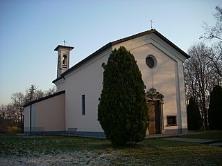
Pescate (Lecchese: Pescàa) is a comune (municipality) in the Province of Lecco in the Italian region Lombardy, located about 45 kilometres (28 mi) northeast of Milan and about 2 kilometres (1 mi) south of Lecco. As of 31 December 2004, it had a population of 2,120 and an area of 2.1 square kilometres (0.81 sq mi). [1]

<i>Comune</i> third-level administrative divisions of the Italian Republic

The comune is a basic administrative division in Italy, roughly equivalent to a township or municipality.

Province of Lecco Province of Italy

The Province of Lecco is a province in the Lombardy region of Italy. Its capital is the city of Lecco.

Italy republic in Southern Europe

Italy, officially the Italian Republic, is a European country consisting of a peninsula delimited by the Italian Alps and surrounded by several islands. Located in the middle of the Mediterranean sea and traversed along its length by the Apennines, Italy has a largely temperate seasonal climate. The country covers an area of 301,340 km2 (116,350 sq mi) and shares open land borders with France, Slovenia, Austria, Switzerland and the enclaved microstates of Vatican City and San Marino. Italy has a territorial exclave in Switzerland (Campione) and a maritime exclave in the Tunisian sea (Lampedusa). With around 60 million inhabitants, Italy is the fourth-most populous member state of the European Union.

Contents

The municipality of Pescate contains the frazioni (subdivisions, mainly villages and hamlets) Pescalina, Insirano, Torrette Inferiori, and Torrette Superiori.

"Frazione" is the Italian name given in administrative law to a type of territorial subdivision of a comune; for other administrative divisions, see municipio, circoscrizione, quartiere. It is cognate to the English word fraction, but in practice is roughly equivalent to "parishes" or "wards" in other countries.

Pescate borders the following municipalities: Galbiate, Garlate, Lecco.

Galbiate Comune in Lombardy, Italy

Galbiate is a comune (municipality) in the Province of Lecco in the Italian region Lombardy, located about 40 kilometres (25 mi) northeast of Milan and about 6 kilometres (4 mi) south of Lecco.

Garlate Comune in Lombardy, Italy

Garlate is a comune (municipality) in the Province of Lecco in the Italian region Lombardy, located about 40 kilometres (25 mi) northeast of Milan and about 6 kilometres (4 mi) south of Lecco. As of 31 December 2004, it had a population of 2,630 and an area of 2.1 square kilometres (0.81 sq mi).

Lecco Comune in Lombardy, Italy

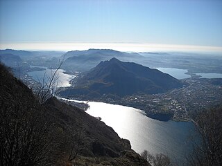
Lecco is a city of 48,131 inhabitants in Lombardy, northern Italy, 50 kilometres (31 mi) north of Milan, the capital of the province of Lecco. It lies at the end of the south-eastern branch of Lake Como. The Bergamo Alps rise to the north and east, cut through by the Valsassina of which Lecco marks the southern end.

Demographic evolution

Pescate

Related Research Articles

Airuno Comune in Lombardy, Italy

Airuno is a comune (municipality) in the Province of Lecco in the Italian region Lombardy, located about 35 kilometres (22 mi) northeast of Milan and about 11 kilometres (7 mi) south of Lecco. As of 31 December 2004, it had a population of 2,749 and an area of 4.3 square kilometres (1.7 sq mi).

Bulciago Comune in Lombardy, Italy

Bulciago is a comune (municipality) in the Province of Lecco in the Italian region Lombardy, located about 35 kilometres (22 mi) northeast of Milan and about 14 kilometres (9 mi) southwest of Lecco. As of 31 December 2004, it had a population of 2,811 and an area of 3.1 square kilometres (1.2 sq mi).

Calco Comune in Lombardy, Italy

Calco is a comune (municipality) in the Province of Lecco in the Italian region Lombardy, located about 35 kilometres (22 mi) northeast of Milan and about 15 kilometres (9 mi) south of Lecco. As of 31 December 2004, it had a population of 4,284 and an area of 4.6 square kilometres (1.8 sq mi).

Carenno Comune in Lombardy, Italy

Carenno is a comune (municipality) in the Province of Lecco in the Italian region Lombardy, located about 45 kilometres (28 mi) northeast of Milan and about 8 kilometres (5 mi) southeast of Lecco. As of 31 December 2004, it had a population of 1,476 and an area of 7.9 square kilometres (3.1 sq mi).

Cernusco Lombardone Comune in Lombardy, Italy

Cernusco Lombardone is a comune (municipality) in the Province of Lecco in the Italian region Lombardy, located about 30 kilometres (19 mi) northeast of Milan and about 15 kilometres (9 mi) south of Lecco. As of 31 December 2007, it had a population of 3,863 and an area of 3.8 square kilometres (1.5 sq mi).

Civate Comune in Lombardy, Italy

Civate is a comune (municipality) in the Province of Lecco in the Italian region Lombardy, located about 45 kilometres (28 mi) northeast of Milan and about 4 kilometres (2 mi) southwest of Lecco. As of 31 December 2004, it had a population of 3,898 and an area of 9.1 square kilometres (3.5 sq mi). Lago di Annone is located on its borders.

Dolzago Comune in Lombardy, Italy

Dolzago is a comune (municipality) in the Province of Lecco in the Italian region Lombardy, located about 35 kilometres (22 mi) northeast of Milan and about 11 kilometres (6.8 mi) southwest of Lecco. As of 31 December 2004, it had a population of 2,126 and an area of 2.2 square kilometres (0.85 sq mi).

Ello Comune in Lombardy, Italy

Ello is a comune (municipality) in the Province of Lecco in the Italian region Lombardy, located about 40 kilometres (25 mi) northeast of Milan and about 8 kilometres (5 mi) southwest of Lecco. As of 31 December 2004, it had a population of 1,202 and an area of 2.4 square kilometres (0.93 sq mi).

Montevecchia Comune in Lombardy, Italy

Montevecchia is a comune (municipality) in the Province of Lecco in the Italian region Lombardy, located about 30 kilometres (19 mi) northeast of Milan and about 15 kilometres (9 mi) south of Lecco. As of 31 December 2004, it had a population of 2,477 and an area of 5.9 square kilometres (2.3 sq mi).

Morterone Comune in Lombardy, Italy

Morterone is a comune (municipality) in the Province of Lecco in the Italian region Lombardy, located about 50 kilometres (31 mi) northeast of Milan and about 7 kilometres (4 mi) northeast of Lecco. For its population of 33 persons, it was considered the smallest of any comune (municipality) in Italy – in an area of 13.8 square kilometres (5.3 sq mi). For this record is competing with the comune (municipality) of Pedesina, that in the past years had even fewer inhabitants. In 2016 Morterone with its 32 residents became again the smallest Italian comune.

Pasturo Comune in Lombardy, Italy

Pasturo is a comune (municipality) in the Province of Lecco in the Italian region Lombardy, located about 60 kilometres (37 mi) northeast of Milan and about 11 kilometres (7 mi) north of Lecco. As of 31 December 2004, it had a population of 1,798 and an area of 22.1 square kilometres (8.5 sq mi).

Premana Comune in Lombardy, Italy

Premana is a comune (municipality) in the Province of Lecco in the Italian region Lombardy, located about 70 kilometres (43 mi) northeast of Milan and about 20 kilometres (12 mi) north of Lecco. As of 31 December 2004, it had a population of 2,285 and an area of 33.7 square kilometres (13.0 sq mi).

Santa Maria Hoè Comune in Lombardy, Italy

Santa Maria Hoè is a comune (municipality) in the Province of Lecco in the Italian region Lombardy, located about 35 kilometres (22 mi) northeast of Milan and about 11 kilometres (7 mi) south of Lecco. As of 31 December 2004, it had a population of 2,140 and an area of 2.8 square kilometres (1.1 sq mi).

Sirone Comune in Lombardy, Italy

Sirone is a comune (municipality) in the Province of Lecco in the Italian region Lombardy, located about 35 kilometres (22 mi) northeast of Milan and about 11 kilometres (7 mi) southwest of Lecco. As of 31 December 2004, it had a population of 2,270 and an area of 3.2 square kilometres (1.2 sq mi).

Sirtori Comune in Lombardy, Italy

Sirtori is a comune (municipality) in the Province of Lecco in the Italian region Lombardy, located about 35 kilometres (22 mi) northeast of Milan and about 13 kilometres (8 mi) southwest of Lecco. As of 31 December 2004, it had a population of 2,844 and an area of 4.3 square kilometres (1.7 sq mi).

Sueglio Comune in Lombardy, Italy

Sueglio is a comune (municipality) in the Province of Lecco in the Italian region Lombardy, located about 70 kilometres (43 mi) north of Milan and about 25 kilometres (16 mi) north of Lecco.

Suello Comune in Lombardy, Italy

Suello is a comune (municipality) in the Province of Lecco in the Italian region Lombardy, located about 40 kilometres (25 mi) northeast of Milan and about 7 kilometres (4 mi) southwest of Lecco. As of 31 December 2004, it had a population of 1,587 and an area of 2.6 square kilometres (1.0 sq mi). Lago di Annone is located on its borders.

Valmadrera Comune in Lombardy, Italy

Valmadrera is a comune (municipality) in the Province of Lecco in the Italian region Lombardy, located about 45 kilometres (28 mi) northeast of Milan and about 3 kilometres (2 mi) west of Lecco.

References

  1. All demographics and other statistics: Italian statistical institute Istat.