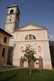
Barzio is a comune (municipality) in the Province of Lecco in the Italian region Lombardy, located in the Valsassina about 60 kilometres (37 mi) northeast of Milan and about 12 kilometres (7 mi) northeast of Lecco.

Calco is a comune (municipality) in the Province of Lecco in the Italian region Lombardy, located about 35 kilometres (22 mi) northeast of Milan and about 15 kilometres (9 mi) south of Lecco. As of 31 December 2004, it had a population of 4,284 and an area of 4.6 square kilometres (1.8 sq mi).

Carenno is a comune (municipality) in the Province of Lecco in the Italian region Lombardy, located about 45 kilometres (28 mi) northeast of Milan and about 8 kilometres (5 mi) southeast of Lecco. As of 31 December 2004, it had a population of 1,476 and an area of 7.9 square kilometres (3.1 sq mi).

Cesana Brianza is a comune (municipality) in the Province of Lecco in the Italian region Lombardy, located about 40 kilometres (25 mi) north of Milan and about 9 kilometres (6 mi) southwest of Lecco. As of 31 December 2004, it had a population of 2,257 and an area of 3.4 square kilometres (1.3 sq mi).

Dolzago is a comune (municipality) in the Province of Lecco in the Italian region Lombardy, located about 35 kilometres (22 mi) northeast of Milan and about 11 kilometres (6.8 mi) southwest of Lecco. As of 31 December 2004, it had a population of 2,126 and an area of 2.2 square kilometres (0.85 sq mi).

Ello is a comune (municipality) in the Province of Lecco in the Italian region Lombardy, located about 40 kilometres (25 mi) northeast of Milan and about 8 kilometres (5 mi) southwest of Lecco. As of 31 December 2004, it had a population of 1,202 and an area of 2.4 square kilometres (0.93 sq mi).

Garlate is a comune (municipality) in the Province of Lecco in the Italian region Lombardy, located about 40 kilometres (25 mi) northeast of Milan and about 6 kilometres (4 mi) south of Lecco. As of 31 December 2004, it had a population of 2,630 and an area of 2.1 square kilometres (0.81 sq mi).

Montevecchia is a comune (municipality) in the Province of Lecco in the Italian region Lombardy, located about 30 kilometres (19 mi) northeast of Milan and about 15 kilometres (9 mi) south of Lecco. As of 31 December 2004, it had a population of 2,477 and an area of 5.9 square kilometres (2.3 sq mi).

Morterone is a comune (municipality) in the Province of Lecco in the Italian region Lombardy, located about 50 kilometres (31 mi) northeast of Milan and about 7 kilometres (4 mi) northeast of Lecco. For its population of 33 persons, it was considered the smallest of any comune (municipality) in Italy – in an area of 13.8 square kilometres (5.3 sq mi). For this record is competing with the comune (municipality) of Pedesina, that in the past years had even fewer inhabitants. In 2016 Morterone with its 32 residents became again the smallest Italian comune.

Olginate is a comune (municipality) in the Province of Lecco in the Italian region Lombardy, located about 40 kilometres (25 mi) northeast of Milan and about 6 kilometres (4 mi) south of Lecco. As of October 2010, it had a population of 7,200 and an area of 7.9 square kilometres (3.1 sq mi).

Premana is a comune (municipality) in the Province of Lecco in the Italian region Lombardy, located about 70 kilometres (43 mi) northeast of Milan and about 20 kilometres (12 mi) north of Lecco. As of 31 December 2004, it had a population of 2,285 and an area of 33.7 square kilometres (13.0 sq mi).

Santa Maria Hoè is a comune (municipality) in the Province of Lecco in the Italian region Lombardy, located about 35 kilometres (22 mi) northeast of Milan and about 11 kilometres (7 mi) south of Lecco. As of 31 December 2004, it had a population of 2,140 and an area of 2.8 square kilometres (1.1 sq mi).

Sirone is a comune (municipality) in the Province of Lecco in the Italian region Lombardy, located about 35 kilometres (22 mi) northeast of Milan and about 11 kilometres (7 mi) southwest of Lecco. As of 31 December 2004, it had a population of 2,270 and an area of 3.2 square kilometres (1.2 sq mi).

Sirtori is a comune (municipality) in the Province of Lecco in the Italian region Lombardy, located about 35 kilometres (22 mi) northeast of Milan and about 13 kilometres (8 mi) southwest of Lecco. As of 31 December 2004, it had a population of 2,844 and an area of 4.3 square kilometres (1.7 sq mi).

Sueglio is a comune (municipality) in the Province of Lecco in the Italian region Lombardy, located about 70 kilometres (43 mi) north of Milan and about 25 kilometres (16 mi) north of Lecco.

Suello is a comune (municipality) in the Province of Lecco in the Italian region Lombardy, located about 40 kilometres (25 mi) northeast of Milan and about 7 kilometres (4 mi) southwest of Lecco. As of 31 December 2004, it had a population of 1,587 and an area of 2.6 square kilometres (1.0 sq mi). Lago di Annone is located on its borders.

Valmadrera is a comune (municipality) in the Province of Lecco in the Italian region Lombardy, located about 45 kilometres (28 mi) northeast of Milan and about 3 kilometres (2 mi) west of Lecco.

Viganò is a comune (municipality) in the Province of Lecco in the Italian region Lombardy, located about 30 kilometres (19 mi) northeast of Milan and about 15 kilometres (9 mi) southwest of Lecco. As of 31 December 2004, it had a population of 1,804 and an area of 1.6 square kilometres (0.62 sq mi).


