Valbrona

Last updated
Valbrona
Valbroeuna  (Lombard)
Comune
Comune di Valbrona
Map of comune of Valbrona (province of Como, region Lombardy, Italy).svg
Italy provincial location map 2015.svg
Red pog.svg
Valbrona
Location of Valbrona in Italy
Coordinates: 45°52′N9°18′E / 45.867°N 9.300°E / 45.867; 9.300 Coordinates: 45°52′N9°18′E / 45.867°N 9.300°E / 45.867; 9.300
Country Italy
Region Lombardy
Province Province of Como (CO)
Area
  Total 13.9 km2 (5.4 sq mi)
Elevation 494 m (1,621 ft)
Population (Dec. 2004)
  Total 2,575
  Density 190/km2 (480/sq mi)
Time zone CET (UTC+1)
  Summer (DST) CEST (UTC+2)
Postal code22039
Dialing code 031

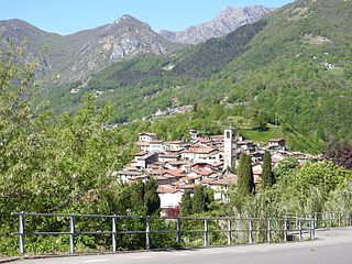
Valbrona (Comasco: Valbroeuna [ʋalˈbrøːna] ) is a comune (municipality) in the Province of Como in the Italian region Lombardy, located about 45 kilometres (28 mi) north of Milan and about 20 kilometres (12 mi) northeast of Como. As of 31 December 2004, it had a population of 2,575 and an area of 13.9 square kilometres (5.4 sq mi). [1]

<i>Comune</i> third-level administrative divisions of the Italian Republic

The comune is a basic administrative division in Italy, roughly equivalent to a township or municipality.

Province of Como Province of Italy

The Province of Como is a province in the north of the Lombardy region of Italy and borders the Swiss cantons of Ticino and Grigioni to the North, the Italian provinces of Sondrio and Lecco to the East, the Province of Monza and Brianza to the south and the Province of Varese to the West. The city of Como is its capital — other large towns, with more than 10,000 inhabitants, include Cantù, Erba, Mariano Comense and Olgiate Comasco. Campione d'Italia also belongs to the province and is enclaved in the Swiss canton of Ticino.

Italy republic in Southern Europe

Italy, officially the Italian Republic, is a country in Southern Europe. Located in the middle of the Mediterranean Sea, Italy shares open land borders with France, Switzerland, Austria, Slovenia and the enclaved microstates San Marino and Vatican City. Italy covers an area of 301,340 km2 (116,350 sq mi) and has a largely temperate seasonal and Mediterranean climate. With around 61 million inhabitants, it is the fourth-most populous EU member state and the most populous country in Southern Europe.

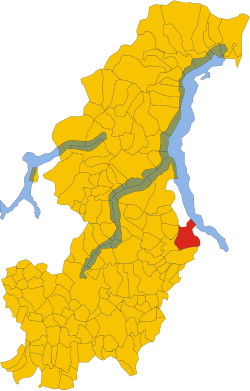
Valbrona borders the following municipalities: Abbadia Lariana, Asso, Canzo, Lasnigo, Mandello del Lario, Oliveto Lario, Valmadrera.

Abbadia Lariana Comune in Lombardy, Italy

Abbadia Lariana is a comune (municipality) in the Province of Lecco in the Italian region Lombardy, located about 50 kilometres (31 mi) northeast of Milan and about 8 kilometres (5 mi) northwest of Lecco. The village has about 3,280 inhabitants and its name is due to the presence of an abbey founded in the 9th century and later destroyed.

Asso Comune in Lombardy, Italy

Asso is an Italian comune in the province of Como, in Lombardy, Italy. It has 3,524 citizens and an area of 6.46 square kilometres (2.49 sq mi), with a density of 546 people per square kilometer.

Canzo Comune in Lombardy, Italy

Canzo is a comune (municipality) of the Italian province of Como. It is the last town north of the historical Brianza region of Lombardy, capital of the Lake Como Triangle community and a regional tourism destination.

Demographic evolution

Valbrona

Related Research Articles

Barni Comune in Lombardy, Italy

Barni is a comune (municipality) in the Province of Como in the Lombardy region of Italy. It is located around 50 kilometres (31 mi) north of Milan and about 20 kilometres (12 mi) northeast of Como.

Bene Lario Comune in Lombardy, Italy

Bene Lario is a comune (municipality) in the Province of Como in the Italian region Lombardy, located about 60 kilometres (37 mi) north of Milan and about 25 kilometres (16 mi) northeast of Como. As of 31 December 2004, it had a population of 319 and an area of 5.7 square kilometres (2.2 sq mi).

Carate Urio Comune in Lombardy, Italy

Carate Urio is a comune (municipality) in the Province of Como in the Italian region Lombardy, located about 45 kilometres (28 mi) north of Milan and about 6 kilometres (4 mi) northeast of Como.

Carlazzo Comune in Lombardy, Italy

Carlazzo is a comune (municipality) in the Province of Como in the Italian region Lombardy, located about 60 kilometres (37 mi) north of Milan and about 25 kilometres (16 mi) north of Como. As of 31 December 2004, it had a population of 2,838 and an area of 12.7 square kilometres (4.9 sq mi).

Caslino dErba Comune in Lombardy, Italy

Caslino d'Erba is a comune (municipality) in the Province of Como in the Italian region Lombardy, located about 40 kilometres (40 km) north of Milan and about 12 kilometres (7.5 mi) east of Como. As of 31 December 2004, it had a population of 1,745 and an area of 7.0 square kilometres (2.7 sq mi).

Cremia Comune in Lombardy, Italy

Cremia is a comune (municipality) in the Province of Como in the Italian region Lombardy, located about 70 kilometres (43 mi) north of Milan and about 35 kilometres (22 mi) northeast of Como, on the western shore of Lake Como.

Faggeto Lario Comune in Lombardy, Italy

Faggeto Lario is a comune (municipality) in the Province of Como in the Italian region of Lombardy, located about 45 kilometres (28 mi) north of Milan and about 7 kilometres (4 mi) northeast of Como. As of 31 December 2004, it had a population of 1,227 and an area of 18.1 km².

Garzeno Comune in Lombardy, Italy

Garzeno is a comune (municipality) in the Province of Como in the Italian region Lombardy, located about 70 kilometres (43 mi) north of Milan and about 35 kilometres (22 mi) northeast of Como.

Gera Lario Comune in Lombardy, Italy

Gera Lario is a comune (municipality) in the Province of Como in the Italian region Lombardy, located about 80 kilometres (50 mi) north of Milan and about 45 kilometres (28 mi) northeast of Como. As of 31 December 2004, it had a population of 942 and an area of 6.7 km².

Grandola ed Uniti Comune in Lombardy, Italy

Grandola ed Uniti is a comune (municipality) in the Province of Como in the Italian region Lombardy, located about 60 kilometres (37 mi) north of Milan and about 25 kilometres (16 mi) northeast of Como. As of 31 December 2004, it had a population of 1,281 and an area of 17.3 km².

Lasnigo Comune in Lombardy, Italy

Lasnigo is a comune (municipality) in the Province of Como in the Italian region Lombardy, located about 45 kilometres (28 mi) north of Milan and about 15 kilometres (9 mi) northeast of Como. As of 31 December 2004, it had a population of 401 and an area of 5.6 km².

Montemezzo Comune in Lombardy, Italy

Montemezzo is a comune (municipality) in the Province of Como in the Italian region Lombardy, located about 80 kilometres (50 mi) north of Milan and about 45 kilometres (28 mi) northeast of Como. As of 31 December 2004, it had a population of 270 and an area of 9.1 km².

Nesso Comune in Lombardy, Italy

Nesso is a comune (municipality) in the Province of Como in the Italian region Lombardy, located about 50 kilometres (31 mi) north of Milan and about 13 kilometres (8 mi) northeast of Como. As of 31 December 2004, it had a population of 1,294 and an area of 15.0 km².

Pianello del Lario Comune in Lombardy, Italy

Pianello del Lario is a comune (municipality) in the Province of Como in the Italian region Lombardy, located about 70 kilometres (43 mi) north of Milan and about 35 kilometres (22 mi) northeast of Como.

Pognana Lario Comune in Lombardy, Italy

Pognana Lario is a comune (municipality) in the Province of Como in the Italian region Lombardy, located about 45 kilometres (28 mi) north of Milan and about 9 kilometres (6 mi) northeast of Como. As of 31 December 2004, it had a population of 871 and an area of 5.0 square kilometres (1.9 sq mi).

Sorico Comune in Lombardy, Italy

Sorico is a comune (municipality) in the Province of Como in the Italian region Lombardy, located about 80 kilometres (50 mi) north of Milan and about 45 kilometres (28 mi) northeast of Como. As of 31 December 2004, it had a population of 1,188 and an area of 23.3 square kilometres (9.0 sq mi).

Trezzone Comune in Lombardy, Italy

Trezzone is a comune (municipality) in the Province of Como in the Italian region Lombardy, located about 80 kilometres (50 mi) north of Milan and about 45 kilometres (28 mi) northeast of Como. As of 31 December 2004, it had a population of 212 and an area of 4.0 square kilometres (1.5 sq mi).

Vercana Comune in Lombardy, Italy

Vercana is a comune (municipality) in the Province of Como in the Italian region Lombardy, located about 80 kilometres (50 mi) north of Milan and about 45 kilometres (28 mi) northeast of Como. As of 31 December 2004, it had a population of 729 and an area of 14.6 square kilometres (5.6 sq mi).

Oliveto Lario Comune in Lombardy, Italy

Oliveto Lario is a comune (municipality) in the Province of Lecco in the Italian region Lombardy, located about 50 kilometres (31 mi) north of Milan and about 15 kilometres (9 mi) northwest of Lecco.

Valmadrera Comune in Lombardy, Italy

Valmadrera is a comune (municipality) in the Province of Lecco in the Italian region Lombardy, located about 45 kilometres (28 mi) northeast of Milan and about 3 kilometres (2 mi) west of Lecco.

References

  1. All demographics and other statistics: Italian statistical institute Istat.