Alserio is a comune (municipality) in the Province of Como in the Italian region Lombardy, located about 35 kilometres (22 mi) north of Milan and about 10 kilometres (6 mi) southeast of Como. As of 31 December 2004, it had a population of 1,127 and an area of 1.9 square kilometres (0.73 sq mi).
Beregazzo con Figliaro is a comune (municipality) within the Province of Como, Lombardy, Italy. The municipality is located about 35 kilometres (22 mi) northwest of Milan and about 11 kilometres (7 mi) southwest of Como. As of 31 December 2004, it had a population of 2,387 and an area of 3.8 square kilometres (1.5 sq mi).
Brenna is a comune (municipality) in the Province of Como in the Italian region Lombardy, located about 30 kilometres (19 mi) north of Milan and about 11 kilometres (7 mi) southeast of Como. As of 31 December 2004, it had a population of 1,860 and an area of 4.9 square kilometres (1.9 sq mi).
Castelmarte is a comune (municipality) in the Province of Como in the Italian region Lombardy, located about 40 kilometres (25 mi) north of Milan and about 12 kilometres (7.5 mi) east of Como. As of 31 December 2004, it had a population of 1,293 and an area of 1.9 square kilometres (0.73 sq mi).

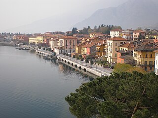
Dongo is a comune in the Province of Como in the Italian region Lombardy. It lies on the northwestern shore of Lake Como between Gravedona and Musso at the mouth of the Albano. It is 70 kilometres (43 mi) north of Milan and about 40 kilometres (25 mi) northeast of Como.
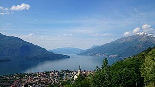
Gravedona ed Uniti is a comune (municipality) in the province of Como in the Italian region of Lombardy, located about 80 kilometres (50 mi) north of Milan and about 40 kilometres (25 mi) northeast of Como.

Lezzeno is a comune (municipality) in the Province of Como in the Italian region Lombardy, located about 50 kilometres (31 mi) north of Milan and about 15 kilometres (9 mi) northeast of Como. As of 31 December 2004, it had a population of 2,088 and an area of 22.5 square kilometres (8.7 sq mi).
Longone al Segrino is a small village and comune between Como and Lecco in the province of Como in Lombardy, Italy. It is located about 40 kilometres (25 mi) north of Milan and about 13 kilometres (8 mi) east of Como. It is known for its lake, an unusual case of an intact ecosystem. As of 31 December 2004, it had a population of 1,543 and an area of 1.5 square kilometres (0.58 sq mi).
Lurate Caccivio is a comune (municipality) in the Province of Como in the Italian region Lombardy, located about 35 kilometres (22 mi) northwest of Milan and about 9 kilometres (6 mi) southwest of Como.

Oltrona di San Mamette is a comune (municipality) in the Province of Como in the Italian region Lombardy, located about 35 kilometres (22 mi) northwest of Milan and about 12 kilometres (7 mi) southwest of Como. As of 31 December 2004, it had a population of 2,190 and an area of 2.7 km2.

Peglio is a comune (municipality) in the Province of Como in the Italian region Lombardy, located about 80 kilometres (50 mi) north of Milan and about 40 kilometres (25 mi) northeast of Como. As of 31 December 2004, it had a population of 209 and an area of 10.8 square kilometres (4.2 sq mi).
Rezzago is a comune (municipality) in the Province of Como in the Italian region Lombardy, located about 45 kilometres (28 mi) north of Milan and about 14 kilometres (9 mi) northeast of Como. As of 30 November 2012, it had a population of 317 and an area of 3.8 square kilometres (1.5 sq mi).

Rovellasca is a comune (municipality) in the Province of Como in the Italian region Lombardy, located about 25 kilometres (16 mi) northwest of Milan and about 15 kilometres (9 mi) south of Como.

Sala Comacina is a comune (municipality) in the Province of Como in the Italian region Lombardy, located about 60 kilometres (37 mi) north of Milan and about 20 kilometres (12 mi) northeast of Como. As of 31 December 2004, it had a population of 618 and an area of 5.3 square kilometres (2.0 sq mi).
Senna Comasco is a comune (municipality) in the Province of Como in the Italian region Lombardy, located about 35 kilometres (22 mi) north of Milan and about 6 kilometres (4 mi) south of Como. As of 31 December 2004, it had a population of 2,995 and an area of 2.7 square kilometres (1.0 sq mi).
Sormano is a comune (municipality) in the Province of Como in the Italian region Lombardy, located about 45 kilometres (28 mi) north of Milan and about 15 kilometres (9 mi) northeast of Como. It is part of the mountain community of the Triangolo lariano, a local government with Canzo as its chief town and comprising the peninsula between the two branches of Lake Como.
Valbrona is a comune (municipality) in the Province of Como in the Italian region Lombardy, located about 45 kilometres (28 mi) north of Milan and about 20 kilometres (12 mi) northeast of Como. As of 31 December 2004, it had a population of 2,575 and an area of 13.9 square kilometres (5.4 sq mi).
Veleso is a comune (municipality) in the Province of Como in the Italian region Lombardy, located about 50 kilometres (31 mi) north of Milan and about 12 kilometres (7 mi) northeast of Como. As of 31 December 2004, it had a population of 275 and an area of 5.9 square kilometres (2.3 sq mi).
Vercana is a comune (municipality) in the Province of Como in the Italian region Lombardy, located about 80 kilometres (50 mi) north of Milan and about 45 kilometres (28 mi) northeast of Como. As of 31 December 2004, it had a population of 729 and an area of 14.6 square kilometres (5.6 sq mi).
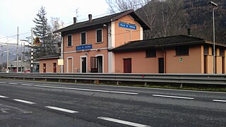
Villa di Tirano is a comune (municipality) in the Province of Sondrio in the Italian region Lombardy, located about 110 kilometres (68 mi) northeast of Milan and about 20 kilometres (12 mi) east of Sondrio, on the border with Switzerland. As of 31 December 2004, it had a population of 2,997 and an area of 24.6 square kilometres (9.5 sq mi).


