La Via dei Monti Lariani

Last updated
La Via dei Monti Lariani
Length 125 km (78 mi)
Location Lombardy
Trailheads Cernobbio, Sorico
Use Hiking
Elevation
Highest point 1300 m
Lowest point 200 m
Hiking details
Sights Views over Lake Como
Hazards streams in spate in wet weather

La Via dei Monti Lariani (variously translated into English as the Monti Lariani Way, the Monti Lariani Trail, or the Lariani Mountain Trail) is a long-distance footpath in the hills on the west side of Lake Como, in Lombardy, Italy. Its total length is approximately 125 km (80 miles), and its average altitude is about 1000 m, compared with the approximately 200 m of the lake shore. The trail starts in Cernobbio, just north-west of the city of Como, and ends at Sorico, at the northern extreme of the lake. The trail is conventionally divided into four numbered sections, each with different waymarking, but these do not correspond to days of walking; Sections 1-3 would each involve at least two days' walking for a normally fit person, while the fourth section is itself divided into two sections each of which could well require more than a single day. The path runs through a mixture of forest and pasture land, frequently offering magnificent views over the lake. [1]

Lake Como lake in Lombardy, Italy

Lake Como is a lake of glacial origin in Lombardy, Italy. It has an area of 146 square kilometres (56 sq mi), making it the third-largest lake in Italy, after Lake Garda and Lake Maggiore. At over 400 metres deep, it is one of the deepest lakes in Europe, and the bottom of the lake is more than 200 metres (660 ft) below sea level.

Lombardy Region of Italy

Lombardy is one of the twenty administrative regions of Italy, in the northwest of the country, with an area of 23,844 square kilometres (9,206 sq mi). About 10 million people, forming one-sixth of Italy's population, live in Lombardy and about a fifth of Italy's GDP is produced in the region, making it the most populous and richest region in the country and one of the richest regions in Europe. Milan, Lombardy's capital, is the second-largest city and the largest metropolitan area in Italy.

Italy republic in Southern Europe

Italy, officially the Italian Republic, is a country in Southern Europe. Located in the middle of the Mediterranean Sea, Italy shares open land borders with France, Switzerland, Austria, Slovenia and the enclaved microstates San Marino and Vatican City. Italy covers an area of 301,340 km2 (116,350 sq mi) and has a largely temperate seasonal and Mediterranean climate. With around 61 million inhabitants, it is the fourth-most populous EU member state and the most populous country in Southern Europe.

Contents

Sections [1]

San Fedele Intelvi was a comune (municipality) in the Province of Como in the Italian region Lombardy, located about 60 kilometres (37 mi) north of Milan and about 15 kilometres (9 mi) north of Como, on the border with Switzerland. On 1 January 2018 it was merged with Casasco d'Intelvi and Castiglione d'Intelvi to form the new comune of Centro Valle Intelvi.

"Frazione" is the Italian name given in administrative law to a type of territorial subdivision of a comune; for other administrative divisions, see municipio, circoscrizione, quartiere. It is cognate to the English word fraction, but in practice is roughly equivalent to "parishes" or "wards" in other countries.

Centro Valle Intelvi Comune in Lombardy, Italy

Centro Valle Intelvi is a comune (municipality) in the Province of Como in the Italian region Lombardy. It was created on 1 January 2018 after the merger of the former comuni of Casasco d'Intelvi, Castiglione d'Intelvi and San Fedele Intelvi.

Terrain

The path is based on old mountain mule-tracks and on the roughly paved stone military roads built during the First World War to service the Cadorna Line of defensive fortifications along the Italo-Swiss border. [1] Accordingly, it typically does not go over peaks, which rise to 1300-2000 m in its neighbourhood, though side excursions to the peaks along established paths are often possible. [2] Sections 1 and 2 are largely on these military roads, with bridges over all significant watercourses; [1] furthermore the underlying rock in this region is mainly limestone, so that the terrain dries quickly. Section 3 is generally on unpaved and sometimes not so well defined paths, [1] and the underlying rock is granite; as a result, in rainy periods some of the streams may be impassible.

Limestone Sedimentary rocks made of calcium carbonate

Limestone is a carbonate sedimentary rock that is often composed of the skeletal fragments of marine organisms such as coral, foraminifera, and molluscs. Its major materials are the minerals calcite and aragonite, which are different crystal forms of calcium carbonate (CaCO3). A closely related rock is dolostone, which contains a high percentage of the mineral dolomite, CaMg(CO3)2. In fact, in old USGS publications, dolostone was referred to as magnesian limestone, a term now reserved for magnesium-deficient dolostones or magnesium-rich limestones.

Granite A common type of intrusive, felsic, igneous rock with granular structure

Granite is a common type of felsic intrusive igneous rock that is granular and phaneritic in texture. Granites can be predominantly white, pink, or gray in color, depending on their mineralogy. The word "granite" comes from the Latin granum, a grain, in reference to the coarse-grained structure of such a holocrystalline rock. Strictly speaking, granite is an igneous rock with between 20% and 60% quartz by volume, and at least 35% of the total feldspar consisting of alkali feldspar, although commonly the term "granite" is used to refer to a wider range of coarse-grained igneous rocks containing quartz and feldspar.

Accommodation

At the level of the path, overnight accommodation is available in numerous Agriturismo establishments and Refugii maintained by local branches of the Club Alpino Italiano (C. A. I., Italian Alpine Club). [1] At frequent points along the path, it is possible to descend by a road or well-maintained track to the villages along the lake shore, where hotels can be found. [1] [2]

Club Alpino Italiano

The Club Alpino Italiano is the senior Italian alpine club which stages climbing competitions, operates alpine huts, marks and maintains paths, and is active in protecting the Alpine environment.

Related Research Articles

Como Comune in Lombardy, Italy

Como is a city and comune in Lombardy, Italy. It is the administrative capital of the Province of Como.

West Highland Way walking path

The West Highland Way is a linear long distance footpath in Scotland. It is 154 km long, running from Milngavie north of Glasgow to Fort William in the Scottish Highlands, with an element of hill walking in the route. The trail, which opened in 1980, was Scotland's first officially designated Long Distance Route, and is now designated by Scottish Natural Heritage as one of Scotland's Great Trails. It is primarily intended as a long distance walking route, and whilst many sections are suitable for mountain biking and horseriding there are obstacles and surfaces that will require these users to dismount in places.

Lake Lugano lake in Switzerland and Italy

Lake Lugano is a glacial lake which is situated on the border between southern Switzerland and Northern Italy. The lake, named after the city of Lugano, is situated between Lake Como and Lago Maggiore. It was cited for the first time by Gregory of Tours in 590 with the name Ceresio, a name which is said to have derived from the Latin word cerasus, meaning cherry, and refers to the abundance of cherry trees which at one time adorned the shores of the lake. The lake appears in documents in 804 under the name Laco Luanasco.

Gandria Quarter in Ticino, Switzerland

Gandria is both a quarter of the city of Lugano in the Swiss canton of Ticino, and a village on the northern shore of Lake Lugano, which forms the core of that quarter. Until 2004, the quarter of Gandria was an independent municipality, joining with Lugano in that year.

<i>Comune</i> third-level administrative divisions of the Italian Republic

The comune is a basic administrative division in Italy, roughly equivalent to a township or municipality.

Brunate Comune in Lombardy, Italy

Brunate is a town and comune in the province of Como in northern Italy, some 50 kilometres (31 mi) northeast of Milan. It has some 1,800 residents, but is much more populated in summer, when tourists rent houses and apartments.

Long Path Hiking trail from George Washington Bridge to Mohawk River valley in upstate New York

The Long Path is a 357-mile (575 km) long-distance hiking trail beginning at the George Washington Bridge in Fort Lee, New Jersey and ending at Altamont, New York, in the Albany area. While not yet a continuous trail, relying on road walks in some areas, it nevertheless takes in many of the popular hiking attractions west of the Hudson River, such as the New Jersey Palisades, Harriman State Park, the Shawangunk Ridge and the Catskill Mountains. It offers hikers a diversity of environments to pass through, from suburbia and sea-level salt marshes along the Hudson to wilderness and boreal forest on Catskill summits 4,000 feet (1,220 m) in elevation.

Giulino Frazione in Lombardy, Italy

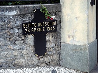
Giulino is an Italian frazione of the Comune of Mezzegra, in the province of Como. Since 21 January 2014 both Giulino and Mezzegra are included in the comune of Tremezzina.

This is a list of trails in Ithaca, New York.

Cernobbio Comune in Lombardy, Italy

Cernobbio is a comune (municipality) in the province of Como, Lombardy, northern Italy. It is located about 40 kilometres (25 mi) north of Milan and about 2 kilometres (1 mi) northwest of Como, on the border with Switzerland and near the Lake Como. The highest peak is the Monte Bisbino, at 1,325 metres (4,347 ft).

E1 European long distance path walking path

The E1 European long-distance path, or just E1 path, is one of the European long-distance paths designated by the European Ramblers' Association. It has a total length of some 4,960 miles (7,980 km). It begins in Norway at Nordkapp, and crosses the Kattegat between Sweden and Denmark by ferry. It passes through Denmark, Germany, and Switzerland to finish at Scapoli, Italy. This path was extended southwards to Sicily, in Italy in 2018.

Sacro Monte di Ossuccio

The Sacro Monte di Ossuccio is one of the nine sacri monti in the Italian regions of Lombardy and Piedmont, in northern Italy, which were inscribed on the UNESCO list of World Heritage Sites in 2003.

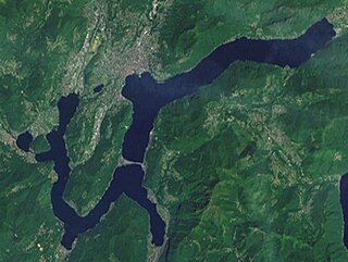
Lago di Mezzola is a small (5.9 km²) lake in the Italian region of Lombardy. It lies between the Pian di Spagna to the south, which divides it from Lake Como and is an ecologically important wetland habitat, and the Piano di Chiavenna to the north, which leads up to Chiavenna. Both are crossed by the river Mera which is Lago di Mezzola’s most important inflow, as well as its sole outflow, and which connects it to Lake Como. The lake has two further inflows, the Codera, which runs through the Val Codera before entering the lake at Novate Mezzola, and the Ratti which runs through the Valle dei Ratti and enters the lake a little to the south at Verceia. The Lago di Mezzola and the Pian di Spagna together make up the Riserva Naturale Pian di Spagna e Lago di Mezzola.

Westweg

The Westweg is a long-distance hiking trail in Germany, running north-south through the Black Forest from Pforzheim to Basel. The trail is around 285 km long, and was founded in 1900. It is currently maintained under the auspices of the Black Forest Club. The trail symbol is a red lozenge on a white background. The Westweg is a part of the European Long-distance Trail E1 The route passes through or near numerous villages or small towns, so there is no difficulty in finding overnight accommodation and meals along the route. It would actually require more planning to walk it while staying in youth hostel-type accommodation, or camping. There are a number of services that will transport your luggage to the next accommodation by vehicle, leaving the hikers with only their daypacks for the hike. The route can be accessed at several places along its length by road or public transport, so it is easy to walk part of it or to do day walks along its route.

Como San Giovanni railway station railway station

Como San Giovanni railway station is the main station serving the city and comune of Como, in the region of Lombardy, northern Italy. Opened in 1875, it forms part of the Milan–Chiasso railway, and is also a terminus of the Como–Lecco railway, which branches off the main line a few kilometres (miles) to the south, at Albate-Camerlata.

San Jorio Pass mountain pass

The San Jorio Pass, located between the Lepontine Alps and the Lugano Prealps at an altitude of 2,012 metres (6,601 ft) above sea level, connects Garzeno in the Italian province of Como with Carena in the Swiss canton of Ticino. It thus offers a route between the shores of Lake Como and the valley of the Ticino river around Bellinzona.

References