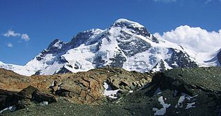
The Breithorn is a mountain range of the Pennine Alps with its highest peak of the same name, located on the border between Switzerland and Italy. It lies on the main chain of the Alps, approximately halfway between the Matterhorn and Monte Rosa and east of the Theodul Pass. Most of the massif is glaciated and includes several subsidiary peaks, all located east of the main summit: the Central Breithorn, the western Breithorn Twin, the Gendarm and the Roccia Nera. The main summit is sometimes distinguished by the name Western Breithorn. The nearest settlements are Zermatt (Valais) and St-Jacques.

Swisstopo is the official name for the Swiss Federal Office of Topography, Switzerland's national mapping agency.

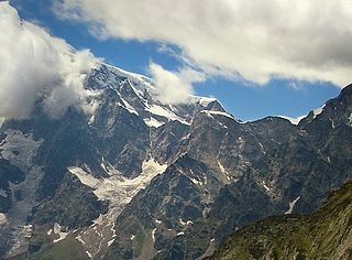
Monte Rosa is a mountain massif in the eastern part of the Pennine Alps. It is between Italy's and Switzerland's (Valais). Monte Rosa is the second highest mountain in the Alps and western Europe, after Mont Blanc.

Lyskamm, also known as Silberbast, is a mountain in the Pennine Alps lying on the border between Switzerland and Italy. It consists of a five-kilometre-long ridge with two distinct peaks. The mountain has gained a reputation for seriousness because of the many cornices lying on the ridge and the frequent avalanches, thus leading to its nickname the Menschenfresser.

Monte Generoso is a mountain of the Lugano Prealps, located on the border between Switzerland and Italy and between Lake Lugano and Lake Como. The western and southern flanks of the mountain lie in the Swiss canton of Ticino, whilst the north-eastern flanks are in the Italian region of Lombardy.
The Jägerhorn is a mountain of the Pennine Alps, located on the border between Switzerland and Italy. It lies just north of Monte Rosa, at a height of 3,970 metres above sea level, and overlooks the village of Macugnaga on its east side, 2,600 metres below. On its west side it overlooks the Gorner Glacier.

The Chasseral is a mountain of the Jura Mountains, overlooking Lake Biel in the Swiss canton of Bern. With an elevation of 1,606 metres above sea level, the Chasseral is the highest summit in the canton of Bern outside the Alps. It is also both the northernmost and easternmost mountain reaching over 1,500 metres in the Jura Mountains. West of the summit is located the Chasseral Ouest, where runs the border with the canton of Neuchâtel. The Chasseral Pass is located further on the west.
The Jazzihorn is a mountain of the Pennine Alps, located on the Swiss-Italian border. On the Italian side it is named Pizzo Cingino Nord as another summit is named Pizzo Cingino Sud on the south. The Jazzihorn has an elevation of 3,227 metres above sea level and lies between the valleys of Saastal (Valais) and Valle d'Antrona (Piedmont).

The Portjengrat is a mountain of the Pennine Alps, located on the border between Switzerland and Italy. It lies south of the Weissmies and the Zwischbergen Pass, where the international border diverges away from the main Alpine watershed. The summit of the Portjengrat has an elevation of 3,654 metres above sea level and is the tripoint between the valleys of Saas, Divedro and Antrona. It is the culminating point of the Antrona valley.

The Gridone, Ghiridone or Monte Limidario is a mountain of the Lepontine Alps, overlooking Lake Maggiore near Brissago. At 2,188 metres above sea level, its summit straddles the border between Italy and Switzerland.

Cima di Castello is a mountain of the Bregaglia Range, located on the border between Italy and Switzerland. With a height of 3,379 metres (11,086 ft) above sea level, it is the second highest mountain in the Bregaglia Range. Its summit lies between the valleys of the Albigna and Forno Glacier and the valley of Val Mello.

Monte Boglia is a mountain whose peak is along the border of Ticino, Switzerland and Lombardy, Italy. It reaches an elevation of 1,516 metres and overlooks Lake Lugano on its southern side.

Sasso Gordona is a mountain of the Lugano Prealps, located west of Lake Como. It lies in the Italian region of Lombardy, just north of the Swiss border with the canton of Ticino. It has an elevation of 1,410 metres above sea level. The Swiss border reaches a height of 1,200 metres, below Rifugio Prabello.

Tambohorn or Pizzo Tambo[ˈpittso ˈtambo] or Pizzo Tambò[ˈpittso tamˈbɔ] is a mountain located at the eastern extremity of the Lepontine Alps on the Swiss-Italian border. The mountain lies on the German-Italian language border, west of the Splügen Pass which divides the Western Alps from the Eastern Alps.
The Cima di Fojorina is a mountain of the Lugano Prealps, located on the border between Switzerland and Italy. It lies on the range separating the Val Colla from Lake Lugano.
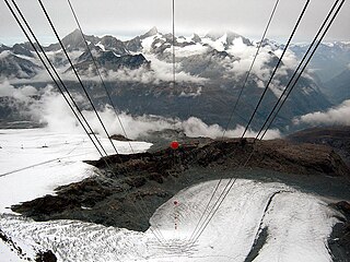
The Theodul Glacier is a glacier of the Alps, located south of Zermatt in the canton of Valais. It lies on the Swiss side of the Pennine Alps, although its upper basin touches the Italian region of the Aosta Valley. The glacier descends from the west side of the Breithorn and splits into two diverging branches above Gandegg: the Upper Theodul Glacier, spilling on a high plateau near Trockener Steg, together with the Furgg Glacier, and the Lower Theodul Glacier, reaching a height of about 2,500 metres (8,202 ft) above the Gorner Glacier. Both branches are part of the Rhone basin, through the rivers Gornera, Mattervispa, and Vispa. Slightly above the glacier splitting is the Theodul Pass, crossing the border between Switzerland and Italy, and connecting Zermatt to Breuil-Cervinia. On the west, the Theodul Glacier is overlooked by the Matterhorn.

Mont d'Or is a mountain of the Jura, located in the French department of Doubs and extending into the Swiss canton of Vaud. Its main summit is 1,463 metre-high and lies within France, 500 metres north of the border with Switzerland. The mountain is located between Jougne, France and Vallorbe, Switzerland.
The Col de Crête Sèche is a mountain pass in the Alps, located between Switzerland and Italy. It lies at a height of 2,896 metres (9,501 ft) above sea level, between the massifs of Mont Gelé and Bec d'Epicoune, in the Pennine Alps. It connects Fionnay in the Swiss canton of Valais on its northern side to Bionaz in the Italian region of the Aosta Valley on its southern side. The Col de Crête Sèche is the second-lowest pass between the valleys of Bagnes and Valpelline, after the Fenêtre de Durand which lies about one hundred metres lower west of Mont Gelé.

