
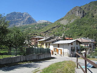
Rocciamelone is a 3,538 m high mountain in Piedmont, Italy, near the border between Italy and France.

The Province of Teramo is a province in the Abruzzo region of Italy. Its capital is the city of Teramo. The province has an area of 1,948 square kilometres (752 sq mi), a population of 313,029 (2012), and is subdivided into 47 comunes, see Comunes of the Province of Teramo. The Province of Teramo shares its northern border with the Province of Ascoli Piceno in the Marche Region, southern and southwestern borders with the Province of L'Aquila in the Abruzzo Region, and a western border with the Province of Rieti in the Region of Lazio. To the south is the Abruzzo Province of Pescara and to the east is the Adriatic Sea.

Piz Bernina is the highest mountain in the Eastern Alps, the highest point of the Bernina Range, and the highest peak in the Rhaetian Alps. It rises 4,048.6 m (13,283 ft) and is located south of Pontresina and near the major Alpine resort of St. Moritz, in the Engadin valley. It is also the most easterly mountain higher than 4,000 m (13,000 ft) in the Alps, the highest point of the Swiss canton of Graubünden, and the fifth-most prominent peak in the Alps. Although the summit lies within Switzerland, the massif is on the border with Italy. The "shoulder" known as La Spedla is the highest point in the Italian Lombardy region.
Acceglio is a comune (municipality) in the Province of Cuneo in the Italian region Piedmont. It is located above Prazzo in the upper Valle Maira about 90 kilometres (56 mi) southwest of Turin and about 45 kilometres (28 mi) west of Cuneo, on the border with France.
Livo is a comune (municipality) in the Province of Como in the Italian region Lombardy, located about 80 kilometres (50 mi) north of Milan and about 40 kilometres (25 mi) northeast of Como, on the border with Switzerland. As of 31 December 2004, it had a population of 212 and an area of 32.5 km².

Gordona is a comune (municipality) in the Province of Sondrio in the Italian region Lombardy, located about 90 kilometres (56 mi) north of Milan and about 40 kilometres (25 mi) northwest of Sondrio, on the border with Switzerland. As of 31 December 2004, it had a population of 1,770 and an area of 49.0 square kilometres (18.9 sq mi).
Menarola is a comune (municipality) in the Province of Sondrio in the Italian region Lombardy, located about 90 kilometres (56 mi) north of Milan and about 45 kilometres (28 mi) northwest of Sondrio, on the border with Switzerland. As of 31 December 2004, it had a population of 40 and an area of 14.8 square kilometres (5.7 sq mi).
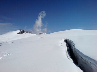
The Cima di Jazzi is a mountain of the Pennine Alps, located on the Swiss-Italian border, just north of Monte Rosa. It overlooks Macugnaga on its east (Italian) side. The west (Swiss) side is entirely covered by glaciers.

The Gazzirola is a mountain of the Lugano Prealps on the Swiss-Italian border. Its summit is the highest point of the municipality of Lugano.

Theodul Pass, elevation 3,295 metres (10,810 ft), is a high mountain pass across the eastern Pennine Alps, connecting Zermatt in the Swiss canton of Valais and Breuil-Cervinia in the Italian region of Aosta Valley. Theodul Pass is the lowest and the easiest pass between the valleys of Zermatt and Valtournanche.

Monte Cusna is the 2nd highest peak in the northern Apennines after Monte Cimone. But, it is much steeper and more remote.

The Jôf di Montasio is located in the Province of Udine, in the Friuli-Venezia Giulia region of northeastern Italy.

The Denti della Vecchia are a mountain of the Lugano Prealps, located north of Lake Lugano on the border between Italy and Switzerland. They are composed of several summits of which the highest is named Sasso Grande.

Pizzo Coca is a mountain that straddles the Val Seriana and the Valtellina in Lombardy, Italy. It is the highest peak in the Bergamo Alps. Its height is 3,050 metres with a prominence height of 1,878 metres and a saddle of 1,172 metres. A post-glacial valley exists near a point called "ometto in sassi" at 2,400 meters.

Refuge Crête Sèche or Rifugio Crête Sèche is a shelter in the Alps of Italy near the border with Switzerland. More precisely, this refuge is located in the valley of Valpelline, a side valley of the Aosta Valley in the Italian Pennine Alps, at 2,410 metres (7,910 ft) above sea level. It lies on the slopes of Mont de Crête Sèche whose summit is at elevation 2,941 metres (9,649 ft).

Rognosa d'Etiache or Rognosa d'Étache is a mountain in the Cottian Alps on the border of Turin, Italy, and Savoie, France. It has an elevation of 3,382 metres above sea level.

The Lugano Prealps are a mountain range in the western part of the Alps. They are located in Canton Ticino and in Lombardy.
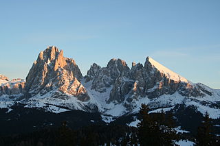
The Langkofel Group is a massif in the (western) Dolomites. It separates Gröden and the Fassa valley, as well as the Sella massif and the Rosengarten. Northwest of the Langkofel is the Seiser Alm. The highest point in the range is the eponymous Langkofel with a height of 3,181 metres. Taken together, the summits of the Langkofel form an arc which is only open towards the northwest. Within this arc there is only one small mountain, the Langkofelkarspitze, so that the group surrounds a kind of "inner courtyard".

The Comasche Prealps are a subsection of the Lugano Prealps. They are found in the Province of Como, Italy, and Canton Ticino, Switzerland. The highest peak is Pizzo di Gino which reaches 2,245 m (7,365 ft) above sea level.

