Gandria

Last updated
Gandria
Quarter
Gandria.jpg
Gandria from Lake Lugano
Gandria Wappen.svg
Karte Quartier Gandria 2013.png
Country Switzerland
Canton Ticino
District Lugano
City Lugano
Area
[1]
  Total3.45 km2 (1.33 sq mi)
Population
 (2012-12-31) [1]
  Total275
  Density80/km2 (210/sq mi)

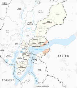
Gandria is both a quarter of the city of Lugano in the Swiss canton of Ticino, and a village on the northern shore of Lake Lugano, which forms the core of that quarter. Until 2004, the quarter of Gandria was an independent municipality, joining with Lugano in that year. [2]

Contents

The quarter of Gandria includes the rural slopes surrounding the village and stretching along the lakeside from the neighboring quarter of Castagnola-Cassarate to the border with Italy. It also includes the slopes on the opposite, (southern) side of the lake around the small settlement of Cantine di Gandria, that are accessible only by boat or on foot. [2]

The historically protected center of the village of Gandria, which is also not accessible by car, attracts visitors from all over the world. While roads now reach the outskirts of the village, many of these visitors arrive by boat services on the lake. It is also possible to walk from Lugano to Gandria and back to Lugano via a footpath, now branded the Olive path, which passes plantations of olive trees and offers views of the Lake of Lugano.

History

Early history

The first lasting human traces on the immediate area around Gandria come from the iron-age people of the Celts (as of 800 B.C.). A large stone (Sasso della Predescia) carved with mysterious signs, probably used for Celtic religious purposes, is located within hiking distance. Many modern locations nearby have Celtic names. Gandria sits at the base of Mt. Brè, which means “mountain” in Celtic. The name of the Lake of Lugano in Italian, Ceresio, could be derived from the Celtic word keresios, a reference to a god of fertility who is always pictured with the antlers of a deer – the lake’s resemblance to the prongs of an antler can be more easily imagined when viewed from above. [3] [4] [5]

Rome conquered the region in 196 B.C. Tombs and artifacts from the neighbouring villages of Castagnola and Brè are testimonials to the Roman presence. Present-day Gandria, however, was not yet inhabited.

First settlement

“Gandrio” is first mentioned in archives from the bishop of Como in 1237. [6] At the time, the village was located halfway up Mt. Bré – the ruins are still visible today along the trail to the Sasso della Predescia.

In the 14th century, a new settlement was established along the lake in the present-day site. Eventually the upper part of the village was abandoned, perhaps due to fire, perhaps due to the advantages of living near the lake. Gandria was only accessible by boat and steep trails, locals had to be self-sufficient. In addition to gardening and raising livestock, they benefited from the lake’s abundant fish.

Olives, silk and smuggling

Olive cultivation in Gandria Olivenkultur am Luganersee bei Gandria.jpg
Olive cultivation in Gandria

Until the unusually hard winter of 1709 killed most of the olive trees, Gandria was known for its olive oil. In recent years, olive trees have been replanted and information panels posted along a scenic lakeside trail to Lugano (Sentiero dell’olivo). [7]

In 1856 silk production began in Gandria, [8] using leaves from local mulberry trees to feed the silkworms. Because of the difficult-to-control border, the area around Gandria became infamous for smuggling. Cigarettes, meat and alcohol were especially profitable due to high Swiss customs duties. (A notable item at the Swiss Customs Museum is a confiscated “submarine” used to smuggle salami).

The year 1935 was the beginning of a new era for Gandria, as tunnels and a new road above the lake shore connected the village to Lugano and Italy.

Merger with Lugano

In 2004, the municipality of Gandria merged with the city of Lugano. Since Gandria became a part of Lugano, needed infrastructure projects have been carried out, including a sewage treatment plant that went on line in August 2010. Work to place electrical lines underground is ongoing. [2] [9]

Sights

Gandria from above with the Church of Saint Vigilio Gandria and the Lake.jpg
Gandria from above with the Church of Saint Vigilio

Church of Saint Vigilio

The Church of Saint Vigilio in Gandria was completed in 1463. The oldest part is the gray, unfinished wall facing the lake, adorned with memorials from well-known local families. The baroque facades were completed in the 1870s. Behind the altar of the church is a large oil painting by Giovanni and Giuseppe Torricelli that shows the martyrdom of Saint Vigilio, a bishop of Trento in Italy, who was stoned to death by pagan shepherds. [10] [11]

The connection with Gandria comes from local artisans who worked on the construction of the cathedral in Trento, and were presumably impressed by the patron saint. The Torricelli brothers also painted scenes in the house of local architect Vigilio Rabaglio, who achieved fame by designing the Bourbon royal palace in Segovia in Spain. An archeological guide to the area notes that stones with Celtic bowl-shaped indentations, carried there by villagers in past centuries, can be seen in the walls and on doorsteps around the Church of San Vigilio. [11]

Swiss Customs Museum

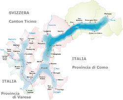
On the opposite side of the lake to Gandria village, but still within the Gandria quarter, is the Swiss Customs Museum. This was once a border post on the adjacent border with Italy, but now forms part of the Swiss National Museum. The museum covers the history of smuggling in the area, and the work of customs officers to counteract it. In a modern context, it covers the work of the Swiss Federal Customs Administration and the Swiss Border Guard. [12]

An international village

The waterfront looking west, with Monte San Salvatore in the distance Lake Lugano - Gandria.jpg
The waterfront looking west, with Monte San Salvatore in the distance

Today, Gandria is a mix of tradition and modernity. Many of 200 inhabitants who live there year-round are from families that go back for many generations. Others have arrived from various cantons of Switzerland as well as countries as diverse as Colombia, Germany, Haiti, Italy, Nicaragua, Palestine and the United States. [13] Most people work in the nearby financial center of Lugano, although there is a tradition of architects, musicians, painters, ceramic makers and other artists in the village.

Transport

Road access to upper levels Gandria 2012 06.jpg
Road access to upper levels

Gandria village and its surrounding areas are connected to Lugano, and to Italy, by the main road that runs along the northern shore of Lake Lugano. This passes above the village centre, which, by virtue of its extremely narrow streets and steep gradients, is inaccessible to vehicles. In addition to the higher level road, it is also possible to walk from Gandria to Lugano and other surrounding villages via the publicly maintained lakeside Olive Path hewn into the rock in 1936.

A boat service between Gandria and other towns on the lake is provided by the Società Navigazione del Lago di Lugano (SNL) and is regular. The same company also operates a bus service between Gandria and Lugano. [14]

The portion of Gandria on the south side of the lake, around Cantine di Gandria and the Swiss Customs Museum, has no roads. The shore-side footpath, which links the area to Caprino, is subject to rockfalls and not recommended for the inexperienced walker. The SNL provide several crossings a day from Gandria village (and central Lugano) to piers at both the Cantine di Gandria and the Customs Museum. [14] [15]

Related Research Articles

<span class="mw-page-title-main">Como</span> Comune in Lombardy, Italy

Como is a city and comune in Lombardy, Italy. It is the administrative capital of the Province of Como.

<span class="mw-page-title-main">Ticino</span> Canton of Switzerland

Ticino, sometimes Tessin, officially the Republic and Canton of Ticino or less formally the Canton of Ticino, is one of the 26 cantons forming the Swiss Confederation. It is composed of eight districts and its capital city is Bellinzona. It is also traditionally divided into the Sopraceneri and the Sottoceneri, respectively north and south of Monte Ceneri. Red and blue are the colours of its flag.

<span class="mw-page-title-main">Lugano</span> Municipality in Switzerland in Ticino

Lugano is a city and municipality in Switzerland, part of the Lugano District in the canton of Ticino. It is the largest city of both Ticino and the Italian-speaking southern Switzerland. Lugano has a population of 62,315, and an urban agglomeration of over 150,000. It is the ninth largest Swiss city.

<span class="mw-page-title-main">Lake Lugano</span> Lake in Italy and Switzerland

Lake Lugano is a glacial lake which is situated on the border between southern Switzerland and northern Italy. The lake, named after the city of Lugano, is situated between Lake Como and Lago Maggiore. It was cited for the first time by Gregory of Tours in 590 with the name Ceresio, a name which is said to have derived from the Latin word cerasus, meaning cherry, and refers to the abundance of cherry trees which at one time adorned the shores of the lake. The lake appears in documents in 804 under the name Laco Luanasco.

<span class="mw-page-title-main">Campione d'Italia</span> Administrative division of Lombardy, Italy

Campione d'Italia is a comune of the Province of Como in the Lombardy region of Italy and an enclave surrounded by the Swiss canton of Ticino. At its closest, the enclave is less than one kilometre (0.6 mi) from the rest of Italy, but the intervening mountainous terrain requires a journey by road through the Swiss village of Bissone of over 14 km (9 mi) to reach the nearest Italian town, Lanzo d'Intelvi, and over 28 km (17 mi) to reach the city of Como.

<span class="mw-page-title-main">Capolago</span> Village and Quarter in Ticino, Switzerland

Capolago is a village situated at the south-eastern extremity of Lake Lugano, in the Swiss canton of Ticino. Originally a municipality in its own right, Capolago is now a quarter of the municipality of Mendrisio, itself part of the district of Mendrisio.

<span class="mw-page-title-main">Brè-Aldesago</span> Quarter in Ticino, Switzerland

Brè-Aldesago is a quarter of the city of Lugano, in the Swiss canton of Ticino.

<span class="mw-page-title-main">Brè</span> Village in Ticino, Switzerland

Brè is a village on the eastern slopes of the mountain of Monte Brè, in the Swiss canton of Ticino. Politically the village forms part of the Brè-Aldesago quarter of the city of Lugano, although until 1972 Brè-Aldesago was an independent municipality, known simply as Brè until 1953.

<span class="mw-page-title-main">Castagnola, Switzerland</span> Village in Ticino, Switzerland

Castagnola is a village on the northern shore of Lake Lugano, below the mountain of Monte Brè, in the Swiss canton of Ticino. Politically the village forms part of the Castagnola-Cassarate quarter of the city of Lugano, although until 1972 Castagnola-Cassarate was an independent municipality under the name Castagnola.

<span class="mw-page-title-main">Caprino, Switzerland</span> Village in Ticino, Switzerland

Caprino is a village on the southern shore of Lake Lugano in the Swiss canton of Ticino, to the east of the Italian exclave of Campione d'Italia and below the summit of Sighignola. Some 0.5 kilometres (0.31 mi) east of Caprino village is Cantine di Caprino, a smaller settlement. Politically both form part of the Castagnola-Cassarate quarter of the city of Lugano, although until 1972 Castagnola-Cassarate was an independent municipality under the name Castagnola.

<span class="mw-page-title-main">Trasporti Pubblici Luganesi</span>

Trasporti Pubblici Luganesi (TPL) is a public transport operator in and around the Swiss city of Lugano. Previously known as the Società luganese dei tramway elettrici, Tranvie elettriche comunali, Azienda comunale del traffico (ACT) and Azienda comunale dei trasporti della Città di Lugano (ACTL), the organisation was founded in 1884 and adopted its current name in 2000.

<span class="mw-page-title-main">Società Navigazione del Lago di Lugano</span>

The Società Navigazione del Lago di Lugano or Lake Lugano Navigation Company (SNL) is a Swiss company operating passenger services on Lake Lugano. The company also operates bus routes in the same area, and is based at Cassarate in the city of Lugano. It was formerly known as the Società di Navigazione e Ferrovie per lago di Lugano and at one time also operated railways in the area.

<span class="mw-page-title-main">Castagnola-Cassarate</span> Quarter in Ticino, Switzerland

Castagnola-Cassarate is a quarter of the city of Lugano, in the Swiss canton of Ticino.

<span class="mw-page-title-main">Swiss Customs Museum</span>

The Swiss Customs Museum, or Museo doganale svizzero, is a museum located in the Swiss canton of Ticino. The museum is sited near Cantine di Gandria, directly across the Lake Lugano from the village of Gandria, and adjacent to the border with Italy. The museum was formerly a border post on that border, but now forms part of the Swiss National Museum.

<span class="mw-page-title-main">Trams in Lugano</span> Lugano tramway network (1896-1964)

The Lugano tramway network was part of the public transport network of Lugano, in the canton of Ticino, Switzerland, for over half a century. Opened in 1896, the network was progressively replaced by the Lugano trolleybus system by 1959, with one independent line surviving until 1964.

<span class="mw-page-title-main">Italy–Switzerland border</span> International border

The border between the modern states of Switzerland and Italy extends for 744 kilometres (462 mi), from the French-Swiss-Italian tripoint at Mont Dolent in the west to the Austrian-Swiss-Italian tripoint near Piz Lad in the east. Much of the border runs across the High Alps, rising above 4,600 metres (15,100 ft) as it passes east of Dufourspitze, but it also descends to the lowest point in Switzerland as it passes Lago Maggiore at below 200 metres (660 ft).

Capo San Martino is a locality in the municipality of Lugano, Switzerland, situated on the eastern side of Monte San Salvatore, along the cantonal road that connects Lugano with Melide. As the name suggests, Capo San Martino is a natural cliff overlooking Lake Lugano.

<span class="mw-page-title-main">Italian Lakes</span> Group of large lakes lying on the south side of the Alps

The Italian Lakes are a group of large lakes lying on the south side of the Alps, in the basin of the river Po and the Mediterranean Sea. As their name suggests, they are essentially located in northern Italy, however, they are also partly located in southern Switzerland. They are all glacial lakes that formed after the retreat of the glaciers at the end of the last ice age. The group is composed of : Lake Orta, Lake Maggiore, Lake Varese, Lake Lugano, Lake Como, Lake Iseo, Lake Idro and Lake Garda. The three largest are all well over 100 km2, they are: Lake Garda, Lake Maggiore and Lake Como.

Castagnola may refer to:

<span class="mw-page-title-main">Olive production in Switzerland</span>

There is a long history of olive cultivation and olive oil production in southern Switzerland. Ticino is the main production region, with the Grisons being the only other production area in the country. Economically, olive production is marginal, as Switzerland lies at the northern limit of the cultivation area.

References

  1. 1 2 "Il quartiere in numeri". Lugano.ch. Archived from the original on 23 March 2013. Retrieved 5 August 2013.
  2. 1 2 3 "Storia del quartiere di Gandria" [History of Gandria] (in Italian). City of Lugano. Archived from the original on 27 September 2012. Retrieved 5 August 2012.
  3. Éluère, Christiane (2004) [1992]. The Celts: First Masters of Europe . ‘New Horizons’ series. Translated by Briggs, Daphne. p. 13. ISBN   978-0-500-30034-3.
  4. Good, Elmar, Magisches Tessin, Wanderungen zu Orten der Kraft, 2008, p. 241
  5. Good, Elmar, Magisches Tessin, Wanderungen zu Orten der Kraft, 2008, p. 242
  6. Grossi, Plinio, Gandria: storia, presenze, tradizioni, problemi, 1984, p. 17
  7. "Olio d'oliva ticinese". Culinary Heritage of Switzerland . Retrieved 9 March 2022. Nel 1494, 1600 e 1709, gli oliveti vennero quasi completamente distrutti dal gelo. Anni dopo, furono accantonati in favore dei gelsi, così da promuovere l'allevamento dei bachi da seta. Verso la fine degli anni '80 del secolo scorso, la coltivazione dell'olivo è stata ripresa[In 1494, 1600 and 1709, frost destroyed almost all the olive trees. Later, they were replaced by mulberry trees to promote the breeding of silkworms. Olive cultivation in Ticino was revived at the end of the 1980s]
  8. Grossi, Plinio, Gandria: storia, presenze, tradizioni, problemi, 1984, p. 138
  9. Confirmed by the municipal office in Lugano (Dicastero del territorio) responsible for this project by phone on August 30, 2010.
  10. Grossi, Plinio, Gandria: Storia, Presenze, Tradizioni, Problemi, 1984, p. 26
  11. 1 2 Benedetta, Giorgio; Felber, Markus; Maspoli, Guido, et al., Gandria: Naturkundlichhistorischer Pfad, Fondo SNAG, Eusi Verlag, Lugano, 2000, pp. 39-39.
  12. "The permanent exhibition". Swiss Federal Customs Administration. Archived from the original on 1 January 2013. Retrieved 2 August 2012.
  13. Bird, Richard, Gandria at a Glance, 2010, p. 2
  14. 1 2 "Timetable summer 2012". Società Navigazione del Lago di Lugano. Archived from the original on 28 July 2012. Retrieved 1 August 2012.
  15. "Caprino - Cantine di Gandria". Lugano Tourism. Retrieved 4 August 2012.


Coordinates: 46°00′N9°00′E / 46.000°N 9.000°E / 46.000; 9.000