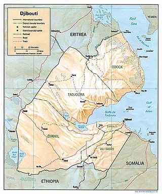
Djibouti is a country in the Horn of Africa. It is bordered by Eritrea in the north, Ethiopia in the west and south, and Somalia in the southeast. To the east is its coastline on the Red Sea and the Gulf of Aden. Rainfall is sparse, and most of the territory has a semi-arid to arid environment. Lake Assal is a saline lake which lies 155 m (509 ft) below sea level, making it the lowest point on land in Africa and the third-lowest point on Earth after the Sea of Galilee and the Dead Sea. Djibouti has the fifth smallest population in Africa. Djibouti's major settlements include the capital Djibouti City, the port towns of Tadjoura and Obock, and the southern cities of Ali Sabieh and Dikhil. It is the forty-six country by area in Africa and 147st largest country in the world by land area, covering a total of 23,200 km2 (9,000 sq mi), of which 23,180 km2 (8,950 sq mi) is land and 20 km2 (7.7 sq mi) is water.
Ethiopia is located in the Horn of Africa. It is bordered by Eritrea to the north, Djibouti and Somalia to the east, Sudan and South Sudan to the west, and Kenya to the south. Ethiopia has a high central plateau, the Abyssinian Highlands that varies from 1,290 to 3,000 m above sea level, with some 25 mountains whose peaks rise over 4,000 meters (13,200ft), the highest being Ras Dashen at 4,543 meters (14,538ft).

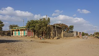
Obock is a small port town in Djibouti. It is located on the northern shore of the Gulf of Tadjoura, where it opens out into the Gulf of Aden. The town is home to an airstrip and has ferries to Djibouti City. The French form Obock derives from Arabic "Oboh", deformation of Oboki, a name given to the Wadi Dar'i in its middle part, upstream of its coastal delta.
Lake Natron is a salt or alkaline lake located in north Ngorongoro District of Arusha Region in Tanzania. It is in the Gregory Rift, which is the eastern branch of the East African Rift. The lake is within the Lake Natron Basin, a Ramsar Site wetland of international significance.

Lake Magadi is the southernmost lake in the Kenyan Rift Valley, lying in a catchment of faulted volcanic rocks, north of Tanzania's Lake Natron. During the dry season, it is 80% covered by soda and is well known for its wading birds, including flamingos.

The Awash is a major river of Ethiopia. Its course is entirely contained within the boundaries of Ethiopia and empties into a chain of interconnected lakes that begin with Lake Gargori and end with Lake Abbe on the border with Djibouti, some 100 kilometres from the head of the Gulf of Tadjoura. It is the principal stream of an endorheic drainage basin covering parts of the Amhara, Oromia and Somali Regions, as well as the southern half of the Afar Region.
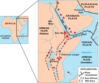
The Afar Triangle is a geological depression caused by the Afar Triple Junction, which is part of the Great Rift Valley in East Africa. The region has disclosed fossil specimens of the very earliest hominins; that is, the earliest of the human clade, and it is thought by some paleontologists to be the cradle of the evolution of humans. The Depression overlaps the borders of Eritrea, Djibouti and the entire Afar Region of Ethiopia; and it contains the lowest point in Africa, Lake Assal, Djibouti, at 155 m (509 ft) below sea level.

The Danakil Desert is a desert in northeast Ethiopia, southern Eritrea, and northwestern Djibouti. Situated in the Afar Triangle, it stretches across 136,956 square kilometres (52,879 sq mi) of arid terrain. It is inhabited by a few Afar, who engage in salt mining. The area is known for its volcanoes and extreme heat, with daytime temperatures surpassing 50 °C (122 °F). Less than 25 mm (1 in) of rainfall occurs each year. The Danakil Desert is one of the lowest and hottest places on Earth.
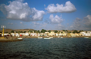
Tadjoura is one of the oldest towns in Djibouti and the capital of the Tadjourah Region. The town evolved into an early Islamic center with the arrival of Muslims shortly after the Hijra. An important port for many centuries, it was ruled by a succession of polities, including the Ifat Sultanate, Adal Sultanate, the Ottoman Empire, France until Djibouti's independence in 1977. Lying on the Gulf of Tadjoura, it is home to a population of around 45,000 inhabitants. It is the third-largest city in the country after Djibouti and Ali Sabieh.
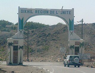
Dikhil is a town in the western Dikhil Region of Djibouti. Lying east of Lake Abbe, It is situated about 122 km (76 mi) southwest of Djibouti City and 12 km (7.5 mi) north of the border with Ethiopia. It serves as the administrative centre of the Dikhil Region, and is home to the Afar and Somali ethnic groups. The town develops gardens and fruit trees.

Asaita (Amharic: አሳይታ, Asayəta; Afar: Aysaqiita), known historically as Aussa (Awsa), is a town in northeastern Ethiopia, and until 2007 served as the capital of the Afar Region of Ethiopia. Located in the Afambo woreda, part of the region's Awsi Rasu zone, the town has a latitude and longitude of 11°34′N41°26′E and an elevation of 300 metres (980 ft).
The Afar Region, formerly known as Region 2, is a regional state in northeastern Ethiopia and the homeland of the Afar people. Its capital is the planned city of Semera, which lies on the paved Awash–Assab highway. It’s bordered by Eritrea to the north and Djibouti to the northeast, and shares regional borders with the Tigray, Amhara, Oromo and Somali regions.

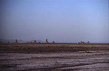
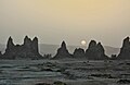
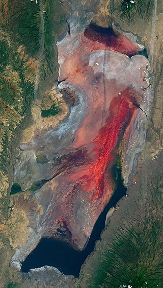
Lake Assal is a crater lake in central-western Djibouti. It is located at the western end of Gulf of Tadjoura between Arta Region, and Tadjoura Region, touching Dikhil Region, at the top of the Great Rift Valley, some 120 km (75 mi) west of Djibouti city. Lake Assal is a saline lake that lies 155 m (509 ft) below sea level in the Afar Triangle, making it the lowest point on land in Africa and the third-lowest point on Earth after the Sea of Galilee and the Dead Sea. No outflow occurs from the lake, and due to high evaporation, the salinity level of its waters is 10 times that of the sea, making it the fourth most saline body of water in the world, behind Garabogazköl, Lake Retba, and Gaet'ale Pond. The salt in the lake is exploited under four concessions awarded in 2002 at the southeast end of the lake; the major share of production is held by Société d’Exploitation du Lac and Société d’Exploitation du Salt Investment S.A de Djibouti.
Aramis is a village and archaeological site in north-eastern Ethiopia, where remains of Australopithecus and Ardipithecus have been found. The village is located in Administrative Zone 5 of the Afar Region, which is part of the Afar Sultanate of Dawe, with a latitude and longitude of 10°30′N40°30′E, and is part of the, Carri Rasuk, Xaale Faagê Daqaara.
The wildlife of Djibouti, consisting of its flora and fauna, is in a harsh landscape with forest accounting for less than one percent of its area. Most species are found in the northern part of the country in the Day Forest National Park at an average elevation of 1,500 metres (4,900 ft), including the massif Goda, with a peak of 1,783 metres (5,850 ft). It covers an area of 3.5 square kilometres (1.4 sq mi) of Juniperus procera forest, with many of the trees rising to 20 metres (66 ft) height. This forest area is the main habitat of the critically endangered and endemic Djibouti spurfowl, and another recently noted vertebrate, Platyceps afarensis. The area also contains many species of woody and herbaceous plants, including boxwood and olive trees, which account for sixty percent of the identified species in the country.

Djibouti, officially the Republic of Djibouti, is a country in the Horn of Africa, bordered by Somalia to the south, Ethiopia to the southwest, Eritrea in the north, and the Red Sea and the Gulf of Aden to the east. The country has an area of 23,200 km2 (8,958 sq mi).

A soda lake or alkaline lake is a lake on the strongly alkaline side of neutrality, typically with a pH value between 9 and 12. They are characterized by high concentrations of carbonate salts, typically sodium carbonate, giving rise to their alkalinity. In addition, many soda lakes also contain high concentrations of sodium chloride and other dissolved salts, making them saline or hypersaline lakes as well. High pH and salinity often coincide, because of how soda lakes develop. The resulting hypersaline and highly alkalic soda lakes are considered some of the most extreme aquatic environments on Earth.
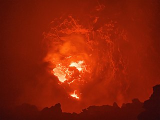
The Danakil Depression is the northern part of the Afar Triangle or Afar Depression in Ethiopia, a geological depression that has resulted from the divergence of three tectonic plates in the Horn of Africa.
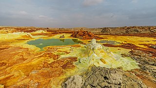
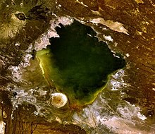
Dallol is a unique, terrestrial hydrothermal system around a cinder cone volcano in the Danakil Depression, northeast of the Erta Ale Range in Ethiopia. It is known for its unearthly colors and mineral patterns, and the very acidic fluids that discharge from its hydrothermal springs.
Mille-Serdo Wildlife Reserve is a protected area in Ethiopia. It is located in Afar Region of Ethiopia. The reserve protects a portion of the Awash River and the surrounding desert.