
Hughes Airwest was a regional airline in the western United States, backed by Howard Hughes' Summa Corporation. Its original name in 1968 was Air West and the air carrier was owned by Nick Bez. Hughes Airwest flew routes in the western U.S. and to several destinations in Mexico and Canada; its headquarters were on the grounds of San Francisco International Airport (SFO) in unincorporated San Mateo County, California.

The Kelabit are an indigenous Dayak people of the Sarawak/North Kalimantan highlands of Borneo with a minority in the neighbouring state of Brunei. They have close ties to the Lun Bawang. The elevation there is slightly over 1,200 meters. In the past, because there were few roads and because the area was largely inaccessible by river because of rapids, the highlands and the Kelabit were relatively untouched by modern western influences. Now, however, there is a relatively permanent road route on which it is possible to reach Bario by car from Miri. The road is marked but driving without a local guide is not advisable, as it takes over 11 hours of driving to reach Bario from Miri through many logging trail junctions and river crossings.

Hora-Dambal also known as Lake Zway or Dambal is one of the freshwater Rift Valley lakes of Ethiopia. It is located about 100 miles south of Addis Ababa, on the border between the Oromia and Southern Nations, Nationalities, and Peoples' Region; the woredas holding the lake's shoreline are Adami Tullu Jido Kombolcha, Dugda, and Batu town. The town of Batu lies on the lake's western shore. The lake is fed primarily by two rivers, the Meki from the west and the Katar from the east, and is drained by the Bulbula which empties into Lake Abijatta. The lake's catchment has an area of 7025 square kilometers.

Lake Abbe, also known as Lake Abhe Bad, is a salt lake, lying on the Ethiopia-Djibouti border. It is one of a chain of six connected lakes, which also includes lakes Gargori, Laitali, Gummare, Bario and Afambo. The lake is the ultimate destination of the Awash River, which is at the center of the Afar Depression. Lake Abbe is considered one of the most inaccessible areas of the earth. The water itself is known for its flamingos. The scenery is unique.

Lake Hughes is an unincorporated community in northern Los Angeles County, California. It is in the Sierra Pelona Mountains, northwest of Palmdale and north of the Santa Clarita Valley, in the Angeles National Forest. It is on the sag pond waters of Lake Hughes and Elizabeth Lake. The community is rural in character, with a population of 649 in 2010, but also has a strong recreational element centered on the three lakes in the vicinity. The community of Elizabeth Lake is located just east of Lake Hughes, sharing the same ZIP code.

Little Moreton Hall, also known as Old Moreton Hall, is a moated half-timbered manor house 4.5 miles (7.2 km) southwest of Congleton in Cheshire, England. The earliest parts of the house were built for the prosperous Cheshire landowner William Moreton in about 1504–08, and the remainder was constructed in stages by successive generations of the family until about 1610. The building is highly irregular, with three asymmetrical ranges forming a small, rectangular cobbled courtyard. A National Trust guidebook describes Little Moreton Hall as being "lifted straight from a fairy story, a gingerbread house". The house's top-heavy appearance, "like a stranded Noah's Ark", is due to the Long Gallery that runs the length of the south range's upper floor.

The tailless fruit bat is a species of fruit bat in the family Pteropodidae.

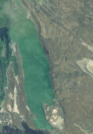
Lake Langano is a lake in the Oromia Region of Ethiopia, exactly 200 kilometers by road south of the capital, Addis Ababa, on the border between the East Shewa Zone and Arsi Zones. It is located to the east of Lake Abijatta in the Main Ethiopian Rift at an elevation of 1,585 meters.

Ba'kelalan is a group of nine villages at Maligan Highlands of Limbang Division, Sarawak, Malaysia about 3,000 feet (910 m) above sea level and 4 km from the border with Indonesian Kalimantan and 150 km from the nearest town of Lawas. There are nine villages in Ba'kelalan. The villagers here belong to the Lun Bawang tribe.

Bario Airport is an airport in Bario, a town in the state of Sarawak in Malaysia.

Bario is a community of 13 to 16 villages located on the Kelabit Highlands in Miri Division, Sarawak, Malaysia, lying at an altitude of 1000 m (3280 ft) above sea level. It is located close to the Sarawak-Kalimantan border, 178 km to the east of Miri. It is the main settlement for the indigenous Kelabit tribe. There are regular flights between the Bario, Miri and Marudi.

The Katonga River is a river in Uganda, in East Africa.

The Nyabarongo is a major river in Rwanda, part of the upper headwaters of the Nile. With a total length of 351 km (218 mi), it is the longest river entirely in Rwanda. It is extended 421 km (262 mi) in Lake Rweru including a 69 km (43 mi) upper course of Kagera River before joining into Ruvuvu River to form the Kagera River. The river begins its course at the confluence of the rivers Mbirurume and Mwogo in the South West of the country. These two rivers themselves begin in Nyungwe Forest, and are considered by some to be the most distant source of the Nile. From its start, Nyabarongo flows northward for 85 km, and forms the border between the Western and Southern Provinces. At the confluence with the river Mukungwa, the river changes course and flows eastward for 12 km, then to a more South Eastern course for the last 200 km. For the longest stretch of this course, the river serves as the boundary between the Northern and Southern Provinces, then between the City of Kigali and the Southern Province, and lastly between the City of Kigali and the Eastern Province.
Lake Afambo is one of a chain of lakes into which the Awash River empties its waters. It is located at the eastern end of the Afar Region of Ethiopia.

Lake Gummare is one of a chain of lakes into which the Awash River empties its waters. It is located at the eastern end of the Afar Region of Ethiopia.
The Wembere River is a river located in north western Singida Region, Tanzania. The river is part of the water basin of Lake Eyasi.

The Southern Ewaso Ng'iro is a river in the Great Rift Valley in Kenya. It plays an important role in the ecology of Lake Natron, the main regular breeding site for near-threatened lesser flamingos. Changes to land use in the river's headwaters or in the marshes before the river enters the lake could have a serious impact on this species.

Lake Burera or Bulera is a lake of northwestern Rwanda, at the border with Uganda. With an area pf 55 km2 (20 sq mi), it is the second largest lake entirely in Rwanda after Lake Ihema. Considering all other lakes in the country, it would be the 5th largest after Lake Kivu 2,700 km2 (1,040 sq mi) between Rwanda and the Democratic Republic of the Congo, Lake Rweru between Rwanda and Burundi at 133 km2 (50 sq mi) of which only 47 km2 (20 sq mi) are in Rwanda, Lake Ihema and Lake Cohoha 74 km2 (30 sq mi) also shared with Burundi of which only 19 km2 (10 sq mi) are in Rwanda. The lake is located in a densely populated North of the country in Burera District which got its name from this lake. The closet major city is the city of Musanze 25 km (16 mi) West of the lake.

iBario was an internet marketing conglomerate based in Israel.

Addie C. Strong Engle was an American author and publisher. She was one of the oldest Past Grand Matrons, Order of the Eastern Star, of Connecticut. She died in 1926.

