
The Great Rift Valley is a series of contiguous geographic trenches, approximately 7,000 kilometres (4,300 mi) in total length, that runs from Lebanon in Asia to Mozambique in Southeast Africa. While the name continues in some usages, it is rarely used in geology as it is considered an imprecise merging of separate though related rift and fault systems.
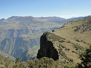
Ethiopia is located in the Horn of Africa. It is bordered by Eritrea to the north, Djibouti and Somalia to the east, Sudan and South Sudan to the west, and Kenya to the south. Ethiopia has a high central plateau, the Abyssinian Highlands that varies from 1,290 to 3,000 m above sea level, with some 25 mountains whose peaks rise over 4,000 meters (13,200ft), the highest being Ras Dashen at 4,543 meters (14,538ft).

Sir Wilfred Patrick Thesiger, also known as Mubarak bin Landan was a British military officer, explorer, and writer.

The Awash is a major river of Ethiopia. Its course is entirely contained within the boundaries of Ethiopia and empties into a chain of interconnected lakes that begin with Lake Gargori and end with Lake Abbe on the border with Djibouti, some 100 kilometres from the head of the Gulf of Tadjoura. It is the principal stream of an endorheic drainage basin covering parts of the Amhara, Oromia and Somali Regions, as well as the southern half of the Afar Region.
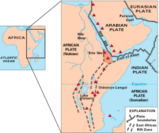
The Afar Triangle is a geological depression caused by the Afar Triple Junction, which is part of the Great Rift Valley in East Africa. The region has disclosed fossil specimens of the very earliest hominins; that is, the earliest of the human clade, and it is thought by some paleontologists to be the cradle of the evolution of humans. The Depression overlaps the borders of Eritrea, Djibouti and the entire Afar Region of Ethiopia; and it contains the lowest point in Africa, Lake Assal, Djibouti, at 155 m (509 ft) below sea level.

Awash Subah is a market town in central Ethiopia. Located in Administrative Zone 3 of the Afar Region, above a gorge on the Awash River, after which the town is named, the town lies on the Addis Ababa–Djibouti Railway, which crosses the gorge by a bridge there. It is the largest settlement in Awash Fentale woreda.
Melka Kunture is a Paleolithic site in the upper Awash Valley, Ethiopia. It is located 50 kilometers south of Addis Ababa by road, across the Awash River from the village of Melka Awash. Three waterfalls lie downstream of the bridge across the Awash here, which provides access south to Butajira.

Lake Abbe, also known as Lake Abhe Bad, is a salt lake, lying on the Ethiopia-Djibouti border. It is one of a chain of six connected lakes, which also includes lakes Gargori, Laitali, Gummare, Bario and Afambo. The lake is the ultimate destination of the Awash River, which is at the center of the Afar Depression. Lake Abbe is considered one of the most inaccessible areas of the earth. The water itself is known for its flamingos. The scenery is unique.

Asaita (Amharic: አሳይታ, Asayəta; Afar: Aysaqiita), known historically as Aussa (Awsa), is a town in northeastern Ethiopia, and until 2007 served as the capital of the Afar Region of Ethiopia. Located in the Afambo woreda, part of the region's Awsi Rasu zone, the town has a latitude and longitude of 11°34′N41°26′E and an elevation of 300 metres (980 ft).

Awash National Park is a national park in Ethiopia. Located at the border of Oromia state and Afar state, the park covers an area of 827 square kilometers, most of it lies at an altitude of 900 meters. Spanning across the southern tip of the Afar Region and the northeastern corner of the East Shewa Zone of Oromia, this park is 225 kilometers east of Addis Ababa. The park is best known for its rich biodiversity and rural landscapes.

Yangudi Rassa National Park is a national park in Ethiopia located in Afar Region.

Awsi Rasu, also known as Administrative Zone 1, is a zone in the Afar Region of Ethiopia. This zone is bordered on the south by Gabi Rasu, on the southwest by Hari Rasu, on the west by the Amhara Region, on the northwest by Fantí Rasu, on the north by Kilbet Rasu, on the northeast by Eritrea, and on the east by Djibouti.
Bure Mudaytu is one of the Districts of Ethiopia, or woredas in the Afar Region of Ethiopia. Part of the Administrative Zone 3, Bure Mudaytu stretches along a narrow band covering the marshy lowlands along the Awash River, with the Administrative Zone 5 to the west and Gewane to the east. The administrative center of this woreda is Debel.

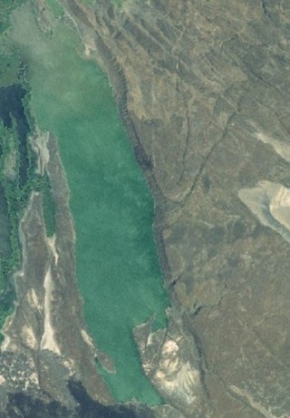
Lake Afrera is a hypersaline lake in northern Ethiopia. Located in Kilbet Rasu, Afar Region, it is one of the lakes of the Danakil Depression. According to its entry in Lakenet, it has a surface area of 100 km2 (39 sq mi), although another source states the area is 125 km2 (48 sq mi). An unconfirmed report gives its depth as 160 m (525 ft); the lake is fed by underground streams.
Gewane is a town in north-eastern Ethiopia. Located in Administrative Zone 3 of the Afar Region, it has an elevation of 618 meters above sea level. Gewane is locally known as New Gewane, 2 kilometers east of the original settlement known as Old Gewane; the town was relocated astride the main, all-weather highway. It is the administrative center of Gewane woreda.
Meteka is a town in north-eastern Ethiopia. Located in Administrative Zone 3 of the Afar Region, 30 kilometers south of Gewane, it has a latitude and longitude of 9°52′N40°31′E with an elevation of 628 meters above sea level. It is one of two towns in Gewane woreda.

The Mille River is a river of Ethiopia and a tributary of the Awash. It drains parts of the Semien (North) Wollo and Debub (South) Wollo Zones of the Amhara Region, as well as Administrative Zone 4 of the Afar Region. The explorer L.M. Nesbitt, who travelled through the area in 1928, was impressed by its size, and described the Mille as "probably the only real river which joins the Awash". The Ala River (A'ura) and Golima River (Golina) are small tributaries of the Mille.
Lake Afambo is one of a chain of lakes into which the Awash River empties its waters. It is located at the eastern end of the Afar Region of Ethiopia.

Lake Bario is one of a chain of lakes into which the Awash River empties its waters. It is located at the eastern end of the Afar Region of Ethiopia. Lake Bario lies in the middle of a swamp, through which it receives its inflow from Lake Afambo to the northeast. Its outflow is on its southern side, which circles around Mount Dama Ali to empty into Lake Abbe.
Mille-Serdo Wildlife Reserve is a protected area in Ethiopia. It is located in Afar Region of Ethiopia. The reserve protects a portion of the Awash River and the surrounding desert.

