
Emilia-Romagna is an administrative region of northern Italy, comprising the historical regions of Emilia and Romagna. Its capital is Bologna. It has an area of 22,446 km2 (8,666 sq mi), and a population of 4.4 million.

The Savio is a river in the Emilia-Romagna region of northern Italy. Its source is in the province of Forlì-Cesena near Montecoronaro on Mount Castelvecchio which is near the western side of Mount Fumaiolo. The source is at an elevation of 1,126 metres (3,694 ft) and is marked by an iron monument. A wolf and the rings of the caveja are on this monument. The river flows near Verghereto and Bagno di Romagna as it winds through the mountains before entering Lago di Quarto. After leaving the lake, the river flows northeast near Sarsina and Mercato Saraceno before flowing north. The river winds for 96 kilometres (60 mi) along the valley. Its natural track has been preserved relatively well and, in the territory of Cesena, it shows an environment which is one of the purest of the whole Romagna. North of Cesena, the river crosses the border into the province of Ravenna. After a total course of 126 kilometres (78 mi) the river enters the Adriatic Sea north of Cervia by Lido di Classe and Lido di Savio.

The Casentino is the valley in which the first tract of the river Arno flows to Subbiano, Italy.

Civitella di Romagna is a comune (municipality) in the Province of Forlì-Cesena in the Italian region Emilia-Romagna, located about 70 kilometres (43 mi) southeast of Bologna and about 30 kilometres (19 mi) southwest of Forlì.
Mercato Saraceno is a comune (municipality) in the Province of Forlì-Cesena in the Italian region Emilia-Romagna, located about 90 kilometres (56 mi) southeast of Bologna and about 35 kilometres (22 mi) southeast of Forlì.

Premilcuore is a comune (municipality) in the Province of Forlì-Cesena in the Italian region Emilia-Romagna, located about 70 kilometres (43 mi) southeast of Bologna and about 35 kilometres (22 mi) southwest of Forlì.

Santa Sofia is a comune (municipality) in the Province of Forlì-Cesena in the Italian region Emilia–Romagna, located about 80 kilometres (50 mi) southeast of Bologna and about 35 kilometres (22 mi) southwest of Forlì. The municipality of Santa Sofia is located in the Bidente river valley and is surrounded by the Foreste Casentinesi, Monte Falterona, Campigna National Park.

Sogliano al Rubicone is a comune (municipality) in the Province of Forlì-Cesena in the Italian region Emilia-Romagna, located about 90 kilometres (56 mi) southeast of Bologna and about 35 kilometres (22 mi) southeast of Forlì.

San Godenzo is a comune (municipality) in the Metropolitan City of Florence in the Italian region Tuscany, located about 35 kilometres (22 mi) northeast of Florence, in the Tuscan-Emilian Apennines.
The Parco Nazionale delle Foreste Casentinesi, Monte Falterona, Campigna is a national park in Italy. Created in 1993, it covers an area of about 368 square kilometres (142 sq mi), on the two sides of the Apennine watershed between Romagna and Tuscany, and is divided between the provinces of Forlì Cesena, Arezzo and Florence.
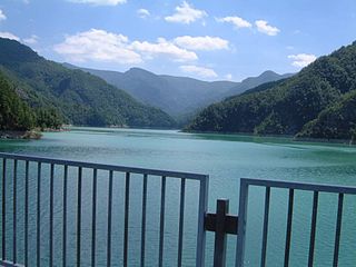
Ridracoli is a frazione of the comune of Bagno di Romagna, province of Forlì-Cesena, Emilia-Romagna.
Castagno d'Andrea is a frazione of the comune of San Godenzo, in the Metropolitan City of Florence, Tuscany (Italy). It is located within the Foreste Casentinesi, Monte Falterona, Campigna National Park.
Mount Fumaiolo is a mountain of the northern Apennines range of Italy located in the southernmost corner of the Emilia-Romagna region, c. 70 km from the town of Cesena. It is at the border Emilia-Romagna and Tuscany. With an elevation of 1,407 metres (4,616 ft), Mount Fumaiolo overlooks the villages of Balze di Verghereto, Bagno di Romagna and Verghereto, in Romagna, and thanks to its extensive fir and beech forests, it is a well-appreciated tourist area of natural interest. It is most famous for being the source of the Tiber, as well as the river Savio.
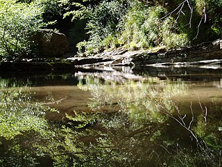
The Acquacheta is a stream in the province of Forlì-Cesena, Romagna, northern Italy. An affluent of the Montone in San Benedetto in Alpe, it is famous because it was mentioned by Dante Alighieri in his Divine Comedy.

The Montone is a river in the historical region of Romagna, which is in the present-day region of Emilia-Romagna in northern Italy. It is the northernmost river on the east-facing slopes of the Apennines to flow directly into the Adriatic Sea rather than entering the Po. Its Latin name was Utis or Vitis.
The Giardino Botanico di Valbonella is a nature preserve and botanical garden in the Foreste Casentinesi, Monte Falterona, Campigna National Park, about 3 kilometers from Corniolo, Santa Sofia, Province of Forlì-Cesena, Emilia-Romagna, Italy. Located at an altitude of 700 meters, it has a surface of two hectares.

The Bidente-Ronco is a river in the Emilia-Romagna region of Italy. The first portion of the river is called the Bidente. Once the river passes under the Ponte dei Veneziani in Meldola, the river is called the Ronco. The source of the river is near the border between the province of Forlì-Cesena, the province of Arezzo, and the province of Florence in the Foreste Casentinesi, Monte Falterona, Campigna National Park. The river flows northeast through the mountains in the province of Forlì-Cesena and flows near Santa Sofia, Galeata, Civitella di Romagna and Meldola. Beyond Meldola, the river flows north near Bertinoro, Forlimpopoli, and Forlì before crossing the border into the province of Ravenna. The river flows northeast until it joins the Montone south of Ravenna, and the resulting river is known as the Uniti. The Battle of Ronco took place here.

Appennino Tosco-Emiliano National Park is a state-held natural preserve in Northern and central Italy, located in the heart of an area noted for natural features and for the local quality products and handicrafts. It was founded in 2001, and is included in the provinces of Massa and Carrara, Lucca, Reggio Emilia and Parma.

The Rabbi is a river in the Tuscany and Emilia-Romagna regions of Italy. The source of the river is in the Foreste Casentinesi, Monte Falterona, Campigna National Park in the Appennino Tosco-Emiliano mountains in the province of Florence. The river crosses the border into the province of Forlì-Cesena and flows northeast near Premilcuore and Predappio before joining the Montone near Forlì.


