
Monte Fitz Roy is a mountain in Patagonia, on the border between Argentina and Chile. It is located in the Southern Patagonian Ice Field, near El Chaltén village and Viedma Lake. It was first climbed in 1952 by French alpinists Lionel Terray and Guido Magnone.
O'Higgins Park, with an area of around 75 hectares, is Santiago, Chile's second largest public park after Metropolitan Park. It is located in the center of the capital, in the Santiago Commune.

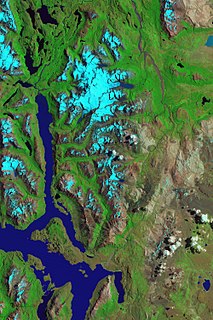
The lake known as O'Higgins in Chile and San Martín in Argentina is located around coordinates 48°50′S72°36′W in Patagonia, between the Aysén del General Carlos Ibáñez del Campo Region and the Santa Cruz Province.

The Southern Patagonian Ice Field, located at the Southern Patagonic Andes between Chile and Argentina, is the world's second largest contiguous extrapolar ice field. It is the bigger of two remnant parts of the Patagonian Ice Sheet, which covered all of southern Chile during the last glacial period, locally called the Llanquihue glaciation.

The Carretera Austral is the name given to Chile's Route 7. The highway runs south for about 1,240 kilometers (770 mi) from Puerto Montt to Villa O'Higgins, passing through rural Patagonia.

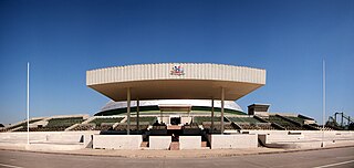
O'Higgins Fútbol Club, also known as O'Higgins de Rancagua, is a Chilean football club based in Rancagua, that is a current member of the Campeonato Nacional. The club's home stadium is the Estadio El Teniente, opened in 1945 and renovated for the 2015 Copa América, which was hosted by Chile.

Bernardo O'Higgins National Park is the largest of the protected areas in Chile, covering an area of 3,525,901 ha in both the Aysén and Magallanes and Antártica Chilena regions. Management of this and other national parks in Chile is entrusted to the Corporación Nacional Forestal (CONAF). The park is named after General Bernardo O'Higgins, the first head of state of the Republic of Chile. Los Glaciares National Park (Argentina) and Torres del Paine National Park are its neighbours to the east, Laguna San Rafael National Park is located to the north, the Alacalufes National Reserve to the southwest and the Katalalixar National Reserve to the northwest.

Baker Channel, also known as Calen Inlet, is a channel of Chile located in the Tortel, Aysén del General Carlos Ibáñez del Campo Region. The Baker River discharges into Martinez Inlet, the northern part of this large estuary. It penetrates the mainland about 75 miles (121 km) and opens into Tarn Bay at the south-east corner of the Gulf of Penas. Merino Jarpa Island lies wholly within this great estuary, while at its mouth lies a group of smaller islands, called Baker Islands, which separate it from Messier Channel. Baker Channel also receives the waters of the O'Higgins/San Martín Lake through the Pascua River. The lake's far-reaching fjord-like arms extend approximately from lat. 49° 11' to 48° 22' S. Its north-west arm is that which drains into the mentioned river.
The Pascua River is a river located in the Aysén del General Carlos Ibáñez del Campo Region of Chile. In spite of being a short river, its drainage basin is the seventh-largest in the country due to the great size of the O'Higgins/San Martín Lake, its source.

The Chilean Antarctic Territory or Chilean Antarctica is the territory in Antarctica claimed by Chile. The Chilean Antarctic Territory ranges from 53° West to 90° West and from the South Pole to the 60° South parallel, partially overlapping the Argentine and British Antarctic claims. It is administered by the Cabo de Hornos municipality in the South American mainland.

O'Higgins Glacier is a glacier located in Bernardo O'Higgins National Park, Chile. It is one of the principal glaciers of the Southern Patagonian Ice Field. The summit of the active Lautaro volcano is the top of the accumulation zone of the glacier. The bulk of the glacier is part of the icefield plateau. It flows eastward into O'Higgins Lake and is about 2 km (1.2 mi) wide at the terminus.

The Zona Sur is one of the five natural regions on which CORFO divided continental Chile in 1950. Its northern border is formed by the Bío-Bío River, the limit with the Central Chile Zone. By west with the Pacific Ocean, by the east with the Andean mountains and Argentina. Its southern border is the Chacao Channel, beyond it lies the Austral Zone. While Chiloé Archipelago belongs geographically to Zona Austral in terms of culture and history it lies closer to Zona Sur.

The following is an alphabetical list of articles related to the Republic of Chile.
Hueinahue River is a river in Futrono and Lago Ranco communes, southern Chile. It drains waters from the cordillera at the Argentine border west to Maihue Lake, which in turn flows by Calcurrupe River into Ranco Lake. The river flows in an east-west direction along the Futrono Fault.
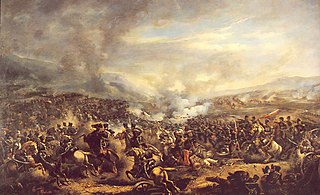
The Battle of El Roble was fought on the Itata river, 17 October 1813, between the Chilean patriot general José Miguel Carrera and Spanish royalist forces under the command of Clemente Lantaño and de Luis Urrejola. The surprise patriot victory at El Roble as a result of Bernardo O'Higgins' actions at the end of the day was to result in a change of patriot commander, and a severe split within the patriot movement.
Sierra de Sangra is an extinct ice-clad stratovolcano with its summit located 10 km east of Villa O'Higgins. The volcanic masiff is heavily eroded and constitutes part of the Argentine-Chilean border in Patagonia.
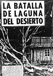
The Laguna del Desierto incident occurred between four Chilean Carabineros and between 40 and 90 members of the Argentine National Gendarmerie and took place in an area south of O'Higgins/San Martín Lake on 6 November 1965, resulting in one lieutenant killed and a sergeant injured, both members of Carabineros, creating a tense atmosphere between Chile and Argentina.
Río Mayer Airport is an airport serving Villa O'Higgins in the Aisén del General Carlos Ibañez del Campo Region of Chile. The town and airport are at the northern end of an arm of Lake O'Higgins, and next to the border with Argentina.

The Del Desierto lake or Lake of the Desert is a lake, located in the Lago Argentino Department, Santa Cruz Province, Argentina. The lake, located near the mount Fitz Roy and the O'Higgins/San Martín Lake, has been the subject of a territorial dispute between Argentina and Chile, escalating to a small battle on 6 November 1965 when 40 to 90 members of the Argentine Gendarmerie fought against four Chilean Carabineros resulting the lieutenant Hernán Merino killed and a sergeant injured, both members of Carabineros, the dispute was solved favourably for Argentina in 1994 with an arbitration.

