
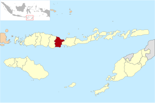
Sikka is a regency within East Nusa Tenggara province, Indonesia, on the island of Flores. It is bordered to the west by Ende Regency and to the east by East Flores Regency. It covers an area of 1,675.36 km2 and had a population of 300,301 at the 2010 census and 321,953 at the 2020 Census; the official estimate as at mid 2023 was 335,360 - comprising 163,060 males and 172,300 females). The capital is the town of Maumere, which comprises the districts of Alok Barat, Alok and Alok Timur.

Bulungan Regency is a regency of North Kalimantan Province in Indonesia. It covers an area of 13,181.92 km2 and had a population of 112,663 at the 2010 Census and 151,844 at the 2020 Census; the official estimate as at mid 2022 was 157,593. The administrative centre is at Tanjung Selor.

Magetan Regency is a regency (kabupaten) of East Java Province, Indonesia. It is an inland regency, and lies in the west of the province, adjoining Central Java Province. It covered an area of 688.84 km2 and had a population of 620,442 at the 2010 Census and 670,812 at the 2020 Census; the official estimate as at mid-2023 was 691,618. The administrative headquarters is in the town of Magetan.

Pamekasan Regency is a regency (kabupaten) of the province of East Java, Indonesia. It is located on Madura Island approximately 120 kilometres (75 mi) east of Surabaya, the provincial capital. The regency covers an area of 792.30 square kilometres (305.91 sq mi), and at the 2010 census it had a population of 795,918 ; at the 2020 census the total was 850,057 and the official estimate as of mid-2023 was 882,837 – comprising 431,891 males and 450,946 females. The administrative capital is the town of Pamekasan.

Trenggalek Regency is a regency (kabupaten) in East Java, Indonesia.

Muaro Jambi Regency is a regency of Jambi Province, Sumatra, Indonesia. It was created on 4 October 1999 by the separation of what were formerly the eastern districts of Batang Hari Regency. It surrounds the major city of Jambi, the provincial capital, and includes many of the expanding suburbs of Jambi outside the city boundaries; consequently it has experienced population growth greater than elsewhere in the province. From the 4th until the 13th century, it was the seat of the Hindu-Buddhist Melayu Kingdom. It has an area of 5,246.00 km2 and had a population of 342,952 at the 2010 census and 390,347 at the 2020 census; the official estimate as at mid 2022 is 412,830.

Barito Kuala Regency is one of the regencies (kabupaten) in the Indonesian province of South Kalimantan, situated in the southwest of the province. The area is 2,996.46 km2, and the population was 276,147 at the 2010 Census and 313,021 at the 2020 Census; the latest official estimate was 321,769. The capital is the town of Marabahan. The Motto of the Regency is "Selidah".

Bintan Regency is an administrative area in the Riau Islands Province of Indonesia. Bintan Regency includes all of Bintan Island and also includes many outlying islands including the Tambelan Archipelago and Badas Islands situated between Bintan and West Kalimantan.

Kutai Kartanegara Regency is a regency of East Kalimantan Province, Indonesia. It has a land area of 27,263.10 km2 and a water area of 4,097 km2, geographically located between 1°18′40″S and 116°31′36″E. The population of the regency was 626,286 at the 2010 Census and 729,382 at the 2020 Census; the official estimate as of mid-2022 was 738,189. The town of Tenggarong is the capital of the regency.

Labuhanbatu Regency, alternatively written in space as Labuhan Batu Regency, is a regency of North Sumatra Province in Indonesia. Its administrative seat is Rantau Prapat. An original regency of the province, it had an area of 9,703 km2 as at early 2008, prior to the separation out of its southern and its north-western districts respectively to create the new South Labuhanbatu and North Labuhanbatu Regencies on 21 July 2008.

Central Bangka Regency is a regency (kabupaten) of the Bangka Belitung Islands Province, Indonesia. It covers an area of 2,155.77 km2 and had a population of 161,075 at the 2010 Census, rising to 198,946 at the 2020 Census; the official estimate as at mid 2022 was 205,510 - comprising 106,340 males and 99,170 females. The town of Koba is its regency seat.
Nagekeo Regency is a regency on the island of Flores in East Nusa Tenggara province of Indonesia. It covers an area of 1,416.96 km2 and had a population of 130,120 at the 2010 Census, and 159,732 at the 2020 Census; the official estimate as at mid 2023 was 166,063, comprising 82,016 males and 83,986 females. The regency was established on 2 January 2007 by separation of the former eastern districts from Ngada Regency; it has its administrative seat (capital) in the town of Mbay on the north coast of Flores. It is bordered to the west by the residual Ngada Regency and to the east by Ende Regency, while to the north is the Flores Sea and to the south is the Savu Sea.

Paser Regency is a regency (kabupaten) within East Kalimantan province in Indonesia, it is the southernmost regency of the East Kalimantan province. Its administrative centre is Tana Paser. It covers an area of 7,730 km2, and it had a population of 230,316 at the 2010 Census and 275,452 at the 2020 Census; the official estimate as at mid-2022 was 280,065 . Before 2007, this regency was formerly named Pasir Regency.

North Penajam Paser Regency is a regency in the Indonesian province of East Kalimantan. Its administrative centre is the town of Penajam. The area which now forms North Penajam Paser was part of Paser Regency until its creation as a separate regency on 10 April 2002. It covers an area of 3,333.06 km2 and it had 142,922 inhabitants at the 2010 census and 178,681 at the 2020 census; the official estimate as at mid-2022 was 183,043. North Penajam Paser Regency has the smallest area among the seven regencies in East Kalimantan province.

Tanggamus Regency is a regency (kabupaten) of Lampung Province, Sumatra, Indonesia. It has an area of 4,654.96 km² and had a population of 534,595 at the 2010 Census and 640,275 at the 2020 Census; the official estimate as at mid 2022 was 652,898. The regency seat is the town of Kota Agung Pusat. The regency was created on 21 March 1997, but districts in its eastern part were split away on 29 October 2008 to form a new Pringsewu Regency. It lies in the southwest of the province, and surrounds Semangka Bay on its west, north and east coasts.
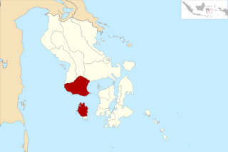
Bombana Regency is a regency of Southeast Sulawesi Province of Indonesia. It consists of part of the southeast peninsula of Sulawesi, together with most of the substantial offshore island of Kabaena to the south. It covers an area of 3,316.16 km2, and had a population on 139,235 at the 2010 Census and 150,706 at the 2020 Census; the official estimate as at mid 2022 was 153,304 - comprising 77,396 males and 75,906 females. The administrative centre lies at the town of Rumbia.
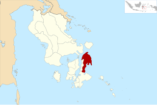
North Buton Regency is a regency of Indonesia's Southeast Sulawesi Province, which was separated from Buton Regency in accordance with Indonesia's Law Number 14 of 2007. The area of the regency, which covers the north part of Buton Island, is 1,923.03 km2. Its population was 54,736 at the 2010 Census and 66,653 at the 2020 Census; the official estimate as at mid 2022 was 69,051. The administrative capital of the regency is at the town of Buranga.

Southeast Maluku Regency is a regency of Maluku, Indonesia. It is coincident with the Kei Islands, except that the city of Tual, although within the Kei Islands geographically and the seat of the Regency's administration, is since 17 July 2007 technically independent of the Regency. The land area of the Regency is 1,016.64 km2, while the sea area administered by the Regency was 3,181 km2; it had a population of 96,442 at the 2010 Census; this increased to 121,511 at the 2020 Census, and the official estimate as at mid 2022 was 124,199.

Pasuruan Regency is a regency in East Java, a province of Indonesia. The capital of this regency is Bangil. The regency covers an area of 1,474.02 km2, and it had a population of 1,512,468 at the 2010 Census and 1,605,969 at the 2020 Census; the official estimate as of mid-2023 was 1,634,022.
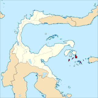
Banggai Laut Regency is a regency in the province of Central Sulawesi, Indonesia. The regency was established on 14 December 2012, partitioned from the Banggai Islands Regency. It comprises southern part of the Banggai Islands archipelago, including the main island of Banggai itself, the islands of Labobo and Bangkurung to the southwest of Banggai Island, and the numerous small Bokan Islands to the southeast. It covers a land area of 725.67 km2, and the districts now comprising the new Regency had a population of 62,183 at the 2010 Census and 70,435 at the 2020 Census; the official estimate as at mid 2022 was 71,350.


