Cilacap Regency is a regency in the southwestern part of Central Java province in Indonesia. Its capital is the town of Cilacap.
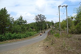
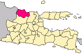
Pacitan Regency is a regency located in the southwestern corner of East Java Province, with Central Java Province on its western border. Located between 7.55° - 8.17°S and 110.55° - 111.25°E. The borders of Pacitan Regency are with Wonogiri Regency in the west and north, Ponorogo Regency and Trenggalek Regency in the east, and the Indian Ocean in the south. It covers an area of 1,389.87 km2 and had a population of 540,881 at the 2010 census and 586,110 at the 2020 census; the official estimate as at mid 2023 was 597,390. The capital of Pacitan Regency is the town of Pacitan. The majority of citizens in Pacitan speak Javanese as their first language, while speaking Indonesian as a second language.

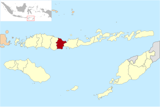
Sikka is a regency within East Nusa Tenggara province, Indonesia, on the island of Flores. It is bordered to the west by Ende Regency and to the east by East Flores Regency. It covers an area of 1,675.36 km2 and had a population of 300,301 at the 2010 census and 321,953 at the 2020 Census; the official estimate as at mid 2023 was 337,011. The capital is the town of Maumere, which comprises the districts of Alok Barat, Alok and Alok Timur.

Maumere is the administrative seat of the Sikka Regency and the second largest town on Flores Island, Indonesia. It lies on the north coast of the island and the port is in the north-west part of the town. Administratively the town is not a single district (kecamatan) within the regency, but is divided into three districts – Alok Barat, Alok and Alok Timur – although the latter two districts also include a number of substantial islands off the north coast of Flores.

Bangkalan Regency is a regency of East Java province in Indonesia. The seat of its government is the town of Bangkalan. The regency is located on the west side of Madura Island, bordering Sampang Regency to the east, Java Sea to the north, and Madura Strait to the west and the south sides. It covers an area of 1,260.15 km2, and had a population of 906,761 at the 2010 census and reached 1,060,377 at the 2020 census; however the official estimate as at mid-2023 showed a decline to 1,047,306 – comprising 515,428 males and 531,878 females.

Pamekasan Regency is a regency (kabupaten) of the province of East Java, Indonesia. It is located on Madura Island approximately 120 kilometres (75 mi) east of Surabaya, the provincial capital. The regency covers an area of 792.30 square kilometres (305.91 sq mi), and at the 2010 census it had a population of 795,918 ; at the 2020 census the total was 850,057 and the official estimate as of mid-2023 was 882,837 – comprising 431,891 males and 450,946 females. The administrative capital is the town of Pamekasan.
Sampang Regency is a regency of East Java province, Indonesia. It is situated on Madura Island, bordering on Pamekasan Regency to the east, the Java Sea to the north, Bangkalan Regency to the west, and Madura Strait to the south. It covers an area of 1,228.25 km2, and had a population of at the 2010 census 877,772 and at the 2020 census 969,694; the official estimate as of mid-2023 was 988,360 - comprising 488,900 males and 499,460 females. The administrative centre is the port of Sampang, on the south coast of Madura.
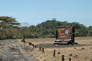
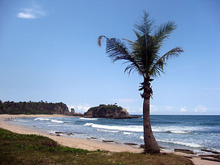
Situbondo Regency is a regency (kabupaten) in the east of East Java province, Indonesia. It covers an area of 1,658.03 km2, and had a population of 647,619 at the 2010 Census and 685,967 at the 2020 Census; the official estimate as at mid 2023 was 684,343. It is located towards the eastern end of Java, before Banyuwangi. The administrative centre is Situbondo, a small town within the regency. One of the famous tourist sites is Baluran National Park.

Sumenep, officially the Sumenep Regency, and formerly rendered Samanap or Zamanap in English, is a regency of the East Java province, Indonesia. It has an area of 2,093.47 square kilometres and the population of 1,142,210 as of 2023. The administrative capital is Kota Sumenep. Since 2014, Sumenep Regency has been recognized by UNESCO as the area that has the most Mpu in the world and most of them are in Aeng Tong-Tong Village.
Tulungagung Regency is a regency (kabupaten) of East Java Province, Indonesia. It covers an area of 1,144.53 km2 and had a population of 990,159 at the 2010 Census and 1,089,775 at the 2020 Census; the official estimate as of mid-2023 was 1,132,144. The administrative headquarters is in the town of Tulungagung.

Sukabumi Regency is a regency (kabupaten) in southwestern Java, as part of West Java province of Indonesia. The regency seat is located in Palabuhan Ratu, a coastal district facing the Indian Ocean. The regency fully encircles the administratively separated city of Sukabumi. Covering an area of 4,164.15 km2, the regency is the largest regency in West Java and the second largest regency on Java after the Banyuwangi Regency in East Java. The regency had a population of 2,341,409 at the 2010 census and 2,725,450 at the 2020 census; the official estimate as at mid 2023 was 2,802,404, with a large proportion of it living in the northeastern part of the regency that encircles Sukabumi City, south of Mount Gede. A plan to create a new regency, the putative North Sukabumi Regency, was considered by the Indonesian government in 2013, but has been deferred until the end of the current morotorium on new creations of regencies.

Alor Regency is a regency in East Nusa Tenggara (NTT) province of Indonesia. Established in 1958, Alor Regency administers the Alor Archipelago with its seat (capital) in Kalabahi on Alor Island.

Kutai Kartanegara Regency is a regency of East Kalimantan Province, Indonesia. It has a land area of 27,263.10 km2 and a water area of 4,097 km2, geographically located between 1°18′40″S and 116°31′36″E. The population of the regency was 626,286 at the 2010 Census and 729,382 at the 2020 Census; the official estimate as of mid-2023 was 788,113. The town of Tenggarong is the capital of the regency.

East Flores Regency is a regency in East Nusa Tenggara province of Indonesia. Established in 1958, the regency has its seat (capital) in Larantuka on Flores Island. It covers a land area of 1,812.65 km2, and it had a population of 232,605 as of the 2010 census and 276,896 at the 2020 Census; the official estimate as of mid-2023 was 289,376. The regency encompasses the eastern tip of the island of Flores, together with all of the adjacent islands of Adonara and Solor to the east of Flores, with some much smaller offshore islands. On 4 October 1999, the island of Lembata at the eastern end of the Solor Archipelago was separated from the East Flores Regency to create its own Regency.

Manggarai Regency is a regency in East Nusa Tenggara province of Indonesia, situated on the island of Flores. Established in 1958 to encompass the 6,924.18 km2 area of the lands of the indigenous Manggarai people, the regency was reduced in area and in population by the separation of the more western districts to form West Manggarai Regency on 25 February 2003 and of the more eastern districts to form East Manggarai Regency on 17 July 2007.
Nagekeo Regency is a regency on the island of Flores in East Nusa Tenggara province of Indonesia, comprising the Nage people in the south and the Keo in the north. It covers an area of 1,377.04 km2 and had a population of 130,120 at the 2010 Census, and 159,732 at the 2020 Census; the official estimate as at mid 2023 was 166,968. The regency was established on 2 January 2007 by separation of the former eastern districts from Ngada Regency; it has its administrative seat (capital) in the town of Mbay on the north coast of Flores. It is bordered to the west by the residual Ngada Regency and to the east by Ende Regency, while to the north is the Flores Sea and to the south is the Savu Sea.

Paser Regency is the southernmost regency (kabupaten) within the East Kalimantan province of Indonesia. It was created in 1959, originally spelt "Pasir Regency", but renamed "Paser" in 2007; however its northeastern districts were split off on 10 April 2002 to form the new Penajam North Paser Regency. The residual regency covers an area of 11,603.94 km2, and it had a population of 230,316 at the 2010 Census and 275,452 at the 2020 Census; the official estimate as at mid-2023 was 303,424. Its administrative centre is the town of Tana Paser.
Sukamara Regency is one of the thirteen regencies which comprise the Central Kalimantan Province on the island of Kalimantan (Borneo), Indonesia. It was created on 10 April 2002 from the former southwest part of West Kotawaringin Regency. The town of Padang contains the administrative centre of Sukamara Regency, and had a population of 6,555 in mid 2023. The Regency covers an area of 3,827 km2, and had a population of 44,952 at the 2010 Census and 63,464 at the 2020 Census; the official estimate as at mid 2023 was 63,039.

Blitar Regency is a regency in East Java, Indonesia. It covers an area of 1,558.79 km2 and had a population of 1,116,639 at the 2010 Census and 1,223,745 at the 2020 Census; the official estimate as at mid 2023 was 1,252,242. These figures exclude Blitar city, which is now a separate administrative entity, enclaved within the regency but completely independent from it. Since 2010, the regency's capital has been located in the town of Kanigoro, after sharing the same capital with Blitar city for more than a century.
Tuban Regency is a regency in the East Java province of Indonesia. The Dutch name of the regency is 'Toeban'. It covers a land area of 1,839.94 sq. km, and had a population of 1,118,464 at the 2010 Census and 1,198,012 at the 2020 Census; the official estimate as of mid-2023 was 1,258,368. The administrative centre is the coastal town of Tuban.