Neftegorsk is a town and the administrative center of Neftegorsky District in Samara Oblast, Russia, located 103 kilometers (64 mi) southeast of Samara, the administrative center of the oblast. Population: 19,254 (2010 Census); 19,388 (2002 Census); 18,895 (1989 Census).

Otradny is a town in Samara Oblast, Russia, located on the left bank of the Bolshoy Kinel River, 91 kilometers (57 mi) east of Samara. Population: 48,356 (2010 Census); 50,048 (2002 Census); 48,767 (1989 Census).

Bezenchuksky District is an administrative and municipal district (raion), one of the twenty-seven in Samara Oblast, Russia. It is located in the west of the oblast. The area of the district is 1,988.8 square kilometers (767.9 sq mi). Its administrative center is the urban locality of Bezenchuk. Population: 42,095 ; 43,571 (2002 Census); 44,003 (1989 Census). The population of Bezenchuk accounts for 54.5% of the district's total population.

Bogatovsky District is an administrative and municipal district (raion), one of the twenty-seven in Samara Oblast, Russia. It is located in the east of the oblast. The area of the district is 824 square kilometers (318 sq mi). Its administrative center is the rural locality of Bogatoye. As of the 2010 Census, the total population of the district was 14,142, with the population of Bogatoye accounting for 41.9% of that number.

Bolshechernigovsky District is an administrative and municipal district (raion), one of the twenty-seven in Samara Oblast, Russia. It is located in the south of the oblast. The area of the district is 2,805.9 square kilometers (1,083.4 sq mi). Its administrative center is the rural locality of Bolshaya Chernigovka. As of the 2010 Census, the total population of the district was 20,477, with the population of Bolshaya Chernigovka accounting for 33.2% of that number.

Isaklinsky District is an administrative and municipal district (raion), one of the twenty-seven in Samara Oblast, Russia. It is located in the northeast of the oblast. The area of the district is 1,578 square kilometers (609 sq mi). Its administrative center is the rural locality of Isakly. Population: 13,395 ; 14,733 (2002 Census); 16,088 (1989 Census). The population of Isakly accounts for 32.4% of the district's total population.

Kamyshlinsky District is an administrative and municipal district (raion), one of the twenty-seven in Samara Oblast, Russia. It is located in the northeast of the oblast. The area of the district is 823.5 square kilometers (318.0 sq mi). Its administrative center is the rural locality of Kamyshla. Population: 11,420 ; 11,868 (2002 Census). The population of Kamyshla accounts for 42.8% of the district's total population.

Khvorostyansky District is an administrative and municipal district (raion), one of the twenty-seven in Samara Oblast, Russia. It is located in the west of the oblast. The area of the district is 2,534 square kilometers (978 sq mi). Its administrative center is the rural locality of Khvorostyanka. Population: 16,302 ; 16,098 (2002 Census); 14,634 (1989 Census). The population of Khvorostyanka accounts for 31.7% of the district's total population.

Kinelsky District is an administrative and municipal district (raion), one of the twenty-seven in Samara Oblast, Russia. It is located in the center of the oblast. The area of the district is 2,103.7 square kilometers (812.2 sq mi). Its administrative center is the town of Kinel. Population: 33,258 ; 30,484 (2002 Census); 31,000 (1989 Census).

Krasnoyarsky District is an administrative and municipal district (raion), one of the twenty-seven in Samara Oblast, Russia. It is located in the northern central part of the oblast. The area of the district is 2,310 square kilometers (890 sq mi). Its administrative center is the rural locality of Krasny Yar. Population: 54,497 ; 55,027 (2002 Census); 50,945 (1989 Census). The population of Krasny Yar accounts for 14.6% of the district's total population.

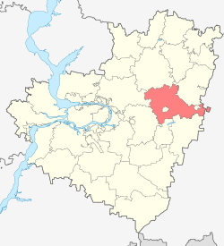
Neftegorsky District is an administrative and municipal district (raion), one of the twenty-seven in Samara Oblast, Russia. It is located in the southeastern central part of the oblast. The area of the district is 1,350 square kilometers (520 sq mi). Its administrative center is the town of Neftegorsk. Population: 34,478 ; 32,246 (2002 Census); 31,406 (1989 Census). The population of Neftegorsk accounts for 55.8% of the district's total population.

Privolzhsky District is an administrative and municipal district (raion), one of the twenty-seven in Samara Oblast, Russia. It is located in the west of the oblast. The area of the district is 1,379.3 square kilometers (532.6 sq mi). Its administrative center is the rural locality of Privolzhye. Population: 24,005 ; 24,552 (2002 Census); 23,058 (1989 Census). The population of Privolzhye accounts for 31.2% of the district's total population.

Shentalinsky District is an administrative and municipal district (raion), one of the twenty-seven in Samara Oblast, Russia. It is located in the northeast of the oblast. The area of the district is 1,338.2 square kilometers (516.7 sq mi). Its administrative center is the rural locality of Shentala. Population: 16,656 ; 18,288 (2002 Census); 20,079 (1989 Census). The population of Shentala accounts for 39.7% of the district's total population.

Stavropolsky District is an administrative and municipal district (raion), one of the twenty-seven in Samara Oblast, Russia. It is located in the west of the oblast. The area of the district is 3,662 square kilometers (1,414 sq mi). Its administrative center is the city of Tolyatti. Population: 54,181 ; 45,167 (2002 Census); 40,347 (1989 Census).

Syzransky District is an administrative and municipal district (raion), one of the twenty-seven in Samara Oblast, Russia. It is located in the west of the oblast. The area of the district is 1,887 square kilometers (729 sq mi). Its administrative center is the city of Syzran. As of the 2010 Census, the total population of the district was 25,947.

Volzhsky District is an administrative and municipal district (raion), one of the twenty-seven in Samara Oblast, Russia. It is located in the center of the oblast. The area of the district is 2,481 square kilometers (958 sq mi). Its administrative center is the city of Samara. Population: 83,377 ; 77,621 (2002 Census); 64,974 (1989 Census).

Yelkhovsky District is an administrative and municipal district (raion), one of the twenty-seven in Samara Oblast, Russia. It is located in the north of the oblast. The area of the district is 1,201 square kilometers (464 sq mi). Its administrative center is the rural locality of Yelkhovka. Population: 10,046 ; 10,187 (2002 Census). The population of Yelkhovka accounts for 32.5% of the district's total population.

Alexeyevka is a rural locality and the administrative center of Alexeyevsky District of Samara Oblast, Russia. Population: 4,513 (2010 Census); 4,626 (2002 Census); 4,846 (1989 Census).

Alexeyevka is an urban locality under the administrative jurisdiction of the town of oblast significance of Kinel of Samara Oblast, Russia. Population: 10,411 (2010 Census); 9,703 (2002 Census); 9,179 (1989 Census).

Ust-Kinelsky is an urban locality under the administrative jurisdiction of the town of oblast significance of Kinel of Samara Oblast, Russia. Population: 9,988 (2010 Census); 8,995 (2002 Census); 7,257 (1989 Census).


