Stavropolsky District

Last updated
Stavropolsky District
Ставропольский район(Russian)
Location Of Stavropolsky District (Samara Oblast).svg
Location of Stavropolsky District in Samara Oblast
Coordinates: 53°29′N49°31′E / 53.483°N 49.517°E / 53.483; 49.517 Coordinates: 53°29′N49°31′E / 53.483°N 49.517°E / 53.483; 49.517
Vid so Strel'noi - panoramio.jpg
View from Strelna, Stavropolsky District
Coat of arms of Stavropolsky district (Samara oblast).png
Flag of Stavropolsky rayon (Samara oblast).png
Coat of arms
Flag
Location
Country Russia
Federal subject Samara Oblast [1]
Administrative structure (as of 2011)
Administrative center city of  Tolyatti [2]
Inhabited localities: [2]
Rural localities 51
Municipal structure (as of October 2010)
Municipally incorporated asStavropolsky Municipal District [3]
Municipal divisions: [4]
Urban settlements0
Rural settlements24
Statistics
Area 3,662 km2 (1,414 sq mi) [5]
Population (2010 Census) 54,181 inhabitants [6]
 Urban0%
 Rural100%
Density 14.8/km2 (38/sq mi) [7]
Time zone SAMT (UTC+04:00) [8]
Official website
Stavropolsky District on WikiCommons

Stavropolsky District (Russian : Ставропо́льский райо́н) is an administrative [1] and municipal [3] district (raion), one of the twenty-seven in Samara Oblast, Russia. It is located in the west of the oblast. The area of the district is 3,662 square kilometers (1,414 sq mi). [5] Its administrative center is the city of Tolyatti [2] (which is not administratively a part of the district). [9] Population: 54,181 (2010 Census); [6] 45,167(2002 Census); [10] 40,347(1989 Census). [11]

Russian language East Slavic language

Russian is an East Slavic language, which is official in the Russian Federation, Belarus, Kazakhstan and Kyrgyzstan, as well as being widely used throughout Eastern Europe, the Baltic states, the Caucasus and Central Asia. It was the de facto language of the Soviet Union until its dissolution on 25 December 1991. Although, nowadays, over two decades after the breakup of the Soviet Union, Russian is used in official capacity or in public life in all the post-Soviet nation-states, as well as in Israel and Mongolia, the rise of state-specific varieties of this language tends to be strongly denied in Russia, in line with the Russian World ideology.

A raion is a type of administrative unit of several post-Soviet states. The term is from the French "rayon", which is both a type of a subnational entity and a division of a city, and is commonly translated in English as "district".

Contents

Administrative and municipal status

Within the framework of administrative divisions, Stavropolsky District is one of the twenty-seven in the oblast. [1] The city of Tolyatti serves as its administrative center, [2] despite being incorporated separately as a town of oblast significance [9] —an administrative unit with the status equal to that of the districts. [1]

Tolyatti City in Samara Oblast, Russia

Tolyatti, also known in English as Togliatti, is a city in Samara Oblast, Russia. Population: 719,632 (2010 Census); 702,879 (2002 Census); 630,543 (1989 Census). It is the largest city in Russia which does not serve as the administrative center of a federal subject.

City of federal subject significance is an umbrella term used to refer to a type of an administrative division of a federal subject of Russia which is equal in status to a district but is organized around a large city; occasionally with surrounding rural territories.

As a municipal division, the district is incorporated as Stavropolsky Municipal District. [3] The city of oblast significance of Tolyatti is incorporated separately from the district as Tolyatti Urban Okrug. [3]

Related Research Articles

Neftegorsk, Samara Oblast Town in Samara Oblast, Russia

Neftegorsk is a town and the administrative center of Neftegorsky District in Samara Oblast, Russia, located 103 kilometers (64 mi) southeast of Samara, the administrative center of the oblast. Population: 19,254 (2010 Census); 19,388 (2002 Census); 18,895 (1989 Census).

Bezenchuksky District District in Samara Oblast, Russia

Bezenchuksky District is an administrative and municipal district (raion), one of the twenty-seven in Samara Oblast, Russia. It is located in the west of the oblast. The area of the district is 1,988.8 square kilometers (767.9 sq mi). Its administrative center is the urban locality of Bezenchuk. Population: 42,095 ; 43,571 (2002 Census); 44,003 (1989 Census). The population of Bezenchuk accounts for 54.5% of the district's total population.

Bogatovsky District District in Samara Oblast, Russia

Bogatovsky District is an administrative and municipal district (raion), one of the twenty-seven in Samara Oblast, Russia. It is located in the east of the oblast. The area of the district is 824 square kilometers (318 sq mi). Its administrative center is the rural locality of Bogatoye. As of the 2010 Census, the total population of the district was 14,142, with the population of Bogatoye accounting for 41.9% of that number.

Bolshechernigovsky District District in Samara Oblast, Russia

Bolshechernigovsky District is an administrative and municipal district (raion), one of the twenty-seven in Samara Oblast, Russia. It is located in the south of the oblast. The area of the district is 2,805.9 square kilometers (1,083.4 sq mi). Its administrative center is the rural locality of Bolshaya Chernigovka. As of the 2010 Census, the total population of the district was 20,477, with the population of Bolshaya Chernigovka accounting for 33.2% of that number.

Isaklinsky District District in Samara Oblast, Russia

Isaklinsky District is an administrative and municipal district (raion), one of the twenty-seven in Samara Oblast, Russia. It is located in the northeast of the oblast. The area of the district is 1,578 square kilometers (609 sq mi). Its administrative center is the rural locality of Isakly. Population: 13,395 ; 14,733 (2002 Census); 16,088 (1989 Census). The population of Isakly accounts for 32.4% of the district's total population.

Kamyshlinsky District District in Samara Oblast, Russia

Kamyshlinsky District is an administrative and municipal district (raion), one of the twenty-seven in Samara Oblast, Russia. It is located in the northeast of the oblast. The area of the district is 823.5 square kilometers (318.0 sq mi). Its administrative center is the rural locality of Kamyshla. Population: 11,420 ; 11,868 (2002 Census). The population of Kamyshla accounts for 42.8% of the district's total population.

Khvorostyansky District District in Samara Oblast, Russia

Khvorostyansky District is an administrative and municipal district (raion), one of the twenty-seven in Samara Oblast, Russia. It is located in the west of the oblast. The area of the district is 2,534 square kilometers (978 sq mi). Its administrative center is the rural locality of Khvorostyanka. Population: 16,302 ; 16,098 (2002 Census); 14,634 (1989 Census). The population of Khvorostyanka accounts for 31.7% of the district's total population.

Kinelsky District District in Samara Oblast, Russia

Kinelsky District is an administrative and municipal district (raion), one of the twenty-seven in Samara Oblast, Russia. It is located in the center of the oblast. The area of the district is 2,103.7 square kilometers (812.2 sq mi). Its administrative center is the town of Kinel. Population: 33,258 ; 30,484 (2002 Census); 31,000 (1989 Census).

Klyavlinsky District District in Samara Oblast, Russia

Klyavlinsky District is an administrative and municipal district (raion), one of the twenty-seven in Samara Oblast, Russia. It is located in the northeast of the oblast. The area of the district is 1,160 square kilometers (450 sq mi). Its administrative center is the rural locality of Klyavlino. Population: 15,988 ; 16,437 (2002 Census); 30,179 (1989 Census). The population of the administrative center accounts for 43.6% of the district's total population.

Krasnoyarsky District, Samara Oblast District in Samara Oblast, Russia

Krasnoyarsky District is an administrative and municipal district (raion), one of the twenty-seven in Samara Oblast, Russia. It is located in the northern central part of the oblast. The area of the district is 2,310 square kilometers (890 sq mi). Its administrative center is the rural locality of Krasny Yar. Population: 54,497 ; 55,027 (2002 Census); 50,945 (1989 Census). The population of Krasny Yar accounts for 14.6% of the district's total population.

Neftegorsky District District in Samara Oblast, Russia

Neftegorsky District is an administrative and municipal district (raion), one of the twenty-seven in Samara Oblast, Russia. It is located in the southeastern central part of the oblast. The area of the district is 1,350 square kilometers (520 sq mi). Its administrative center is the town of Neftegorsk. Population: 34,478 ; 32,246 (2002 Census); 31,406 (1989 Census). The population of Neftegorsk accounts for 55.8% of the district's total population.

Pokhvistnevsky District District in Samara Oblast, Russia

Pokhvistnevsky District is an administrative and municipal district (raion), one of the twenty-seven in Samara Oblast, Russia. It is located in the northeast of the oblast. The area of the district is 2,130 square kilometers (820 sq mi). Its administrative center is the town of Pokhvistnevo. Population: 29,027 ; 30,180 (2002 Census); 32,437 (1989 Census).

Privolzhsky District, Samara Oblast District in Samara Oblast, Russia

Privolzhsky District is an administrative and municipal district (raion), one of the twenty-seven in Samara Oblast, Russia. It is located in the west of the oblast. The area of the district is 1,379.3 square kilometers (532.6 sq mi). Its administrative center is the rural locality of Privolzhye. Population: 24,005 ; 24,552 (2002 Census); 23,058 (1989 Census). The population of Privolzhye accounts for 31.2% of the district's total population.

Shentalinsky District District in Samara Oblast, Russia

Shentalinsky District is an administrative and municipal district (raion), one of the twenty-seven in Samara Oblast, Russia. It is located in the northeast of the oblast. The area of the district is 1,338.2 square kilometers (516.7 sq mi). Its administrative center is the rural locality of Shentala. Population: 16,656 ; 18,288 (2002 Census); 20,079 (1989 Census). The population of Shentala accounts for 39.7% of the district's total population.

Syzransky District District in Samara Oblast, Russia

Syzransky District is an administrative and municipal district (raion), one of the twenty-seven in Samara Oblast, Russia. It is located in the west of the oblast. The area of the district is 1,887 square kilometers (729 sq mi). Its administrative center is the city of Syzran. As of the 2010 Census, the total population of the district was 25,947.

Volzhsky District, Samara Oblast District in Samara Oblast, Russia

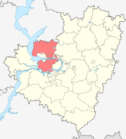
Volzhsky District is an administrative and municipal district (raion), one of the twenty-seven in Samara Oblast, Russia. It is located in the center of the oblast. The area of the district is 2,481 square kilometers (958 sq mi). Its administrative center is the city of Samara. Population: 83,377 ; 77,621 (2002 Census); 64,974 (1989 Census).

Yelkhovsky District District in Samara Oblast, Russia

Yelkhovsky District is an administrative and municipal district (raion), one of the twenty-seven in Samara Oblast, Russia. It is located in the north of the oblast. The area of the district is 1,201 square kilometers (464 sq mi). Its administrative center is the rural locality of Yelkhovka. Population: 10,046 ; 10,187 (2002 Census). The population of Yelkhovka accounts for 32.5% of the district's total population.

Alexeyevka, Alexeyevsky District, Samara Oblast Selo in Samara Oblast, Russia

Alexeyevka is a rural locality and the administrative center of Alexeyevsky District of Samara Oblast, Russia. Population: 4,513 (2010 Census); 4,626 (2002 Census); 4,846 (1989 Census).

Alexeyevka, Kinel, Samara Oblast Work settlement in Samara Oblast, Russia

Alexeyevka is an urban locality under the administrative jurisdiction of the town of oblast significance of Kinel of Samara Oblast, Russia. Population: 10,411 (2010 Census); 9,703 (2002 Census); 9,179 (1989 Census).

Ust-Kinelsky Work settlement in Samara Oblast, Russia

Ust-Kinelsky is an urban locality under the administrative jurisdiction of the town of oblast significance of Kinel of Samara Oblast, Russia. Population: 9,988 (2010 Census); 8,995 (2002 Census); 7,257 (1989 Census).

References

Notes

  1. 1 2 3 4 Charter of Samara Oblast
  2. 1 2 3 4 Государственный комитет Российской Федерации по статистике. Комитет Российской Федерации по стандартизации, метрологии и сертификации. №ОК 019-95 1 января 1997 г. «Общероссийский классификатор объектов административно-территориального деления. Код 36 240», в ред. изменения №278/2015 от 1 января 2016 г.. (State Statistics Committee of the Russian Federation. Committee of the Russian Federation on Standardization, Metrology, and Certification. #OK 019-95 January 1, 1997 Russian Classification of Objects of Administrative Division . Code 36 240, as amended by the Amendment #278/2015 of January 1, 2016. ).
  3. 1 2 3 4 Law #189-GD
  4. Law #67-GD
  5. 1 2 "General Information" (in Russian). Stavropolsky District. Retrieved January 20, 2017.
  6. 1 2 Russian Federal State Statistics Service (2011). "Всероссийская перепись населения 2010 года. Том 1" [2010 All-Russian Population Census, vol. 1]. Всероссийская перепись населения 2010 года (2010 All-Russia Population Census) (in Russian). Federal State Statistics Service . Retrieved June 29, 2012.
  7. The value of density was calculated automatically by dividing the 2010 Census population by the area specified in the infobox. Please note that this value is only approximate as the area specified in the infobox does not necessarily correspond to the area of the entity proper or is reported for the same year as the population.
  8. Правительство Российской Федерации. Федеральный закон №107-ФЗ от 3 июня 2011 г. «Об исчислении времени», в ред. Федерального закона №271-ФЗ от 03 июля 2016 г. «О внесении изменений в Федеральный закон "Об исчислении времени"». Вступил в силу по истечении шестидесяти дней после дня официального опубликования (6 августа 2011 г.). Опубликован: "Российская газета", №120, 6 июня 2011 г. (Government of the Russian Federation. Federal Law #107-FZ of June 31, 2011 On Calculating Time , as amended by the Federal Law #271-FZ of July 03, 2016 On Amending Federal Law "On Calculating Time". Effective as of after sixty days following the day of the official publication.).
  9. 1 2 Государственный комитет Российской Федерации по статистике. Комитет Российской Федерации по стандартизации, метрологии и сертификации. №ОК 019-95 1 января 1997 г. «Общероссийский классификатор объектов административно-территориального деления. Код 36 440», в ред. изменения №278/2015 от 1 января 2016 г.. (State Statistics Committee of the Russian Federation. Committee of the Russian Federation on Standardization, Metrology, and Certification. #OK 019-95 January 1, 1997 Russian Classification of Objects of Administrative Division . Code 36 440, as amended by the Amendment #278/2015 of January 1, 2016. ).
  10. Russian Federal State Statistics Service (May 21, 2004). "Численность населения России, субъектов Российской Федерации в составе федеральных округов, районов, городских поселений, сельских населённых пунктов – районных центров и сельских населённых пунктов с населением 3 тысячи и более человек" [Population of Russia, Its Federal Districts, Federal Subjects, Districts, Urban Localities, Rural Localities—Administrative Centers, and Rural Localities with Population of Over 3,000](XLS). Всероссийская перепись населения 2002 года [All-Russia Population Census of 2002] (in Russian). Retrieved August 9, 2014.
  11. Demoscope Weekly (1989). "Всесоюзная перепись населения 1989 г. Численность наличного населения союзных и автономных республик, автономных областей и округов, краёв, областей, районов, городских поселений и сёл-райцентров" [All Union Population Census of 1989: Present Population of Union and Autonomous Republics, Autonomous Oblasts and Okrugs, Krais, Oblasts, Districts, Urban Settlements, and Villages Serving as District Administrative Centers]. Всесоюзная перепись населения 1989 года [All-Union Population Census of 1989] (in Russian). Институт демографии Национального исследовательского университета: Высшая школа экономики [Institute of Demography at the National Research University: Higher School of Economics]. Retrieved August 9, 2014.

Sources