Russia is divided into several types and levels of subdivisions.
Kalininsky District is the name of several administrative and municipal districts in Russia. The districts are generally named for Mikhail Kalinin, a Soviet statesman.
Omsk Time (OMST) is a time zone in Russia that is six hours ahead of UTC (UTC+06:00), and 3 hours ahead of Moscow Time (MSK).
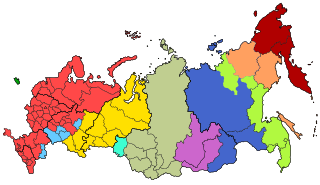
There are eleven time zones in Russia, which currently observe times ranging from UTC+02:00 to UTC+12:00. Daylight saving time (DST) is not used in Russia since 26 October 2014. From 27 March 2011 to 26 October 2014, permanent DST was used.

Sursk is a town in Gorodishchensky District of Penza Oblast, Russia, located on the left bank of the Sura River, 92 kilometers (57 mi) east of Penza, the administrative center of the oblast. Population: 7,034 (2010 Census)
Kamchatka Time or Petropavlovsk Time (PETT; Russian: камчатское время, kamchatskoye vremya), also known as Anadyr Time (ANAT), is a time zone in Russia, named after the Kamchatka Peninsula. It is 12 hours ahead of UTC (UTC+12:00) and 9 hours ahead of Moscow Time (MSK+9). This time zone is used in the two easternmost regions of Russia after October 2014 and was also used before the time zone reform of 2010.

Bashmakovsky District is an administrative and municipal district (raion), one of the twenty-seven in Penza Oblast, Russia. It is located in the west of the oblast. The area of the district is 1,618 square kilometers (625 sq mi). Its administrative center is the urban locality of Bashmakovo. Population: 23,304 ; 25,159 (2002 Census); 28,032 (1989 Census). The population of Bashmakovo accounts for 44.7% of the district's total population.

Gorodishchensky District is an administrative and municipal district (raion), one of the twenty-seven in Penza Oblast, Russia. It is located in the east of the oblast. The area of the district is 2,053 square kilometers (793 sq mi). Its administrative center is the town of Gorodishche. Population: 52,480 ; 53,125 (2002 Census); 58,266 (1989 Census). The population of Gorodishche accounts for 15.4% of the district's total population.

Kamensky District is an administrative and municipal district (raion), one of the twenty-seven in Penza Oblast, Russia. It is located in the western central part of the oblast. The area of the district is 2,174 square kilometers (839 sq mi). Its administrative center is the town of Kamenka. Population: 62,322 ; 24,275 (2002 Census); 27,235 (1989 Census). The population of Kamenka accounts for 63.5% of the district's total population.

Narovchatsky District is an administrative and municipal district (raion), one of the twenty-seven in Penza Oblast, Russia. It is located in the northwest of the oblast. The area of the district is 956.9 square kilometers (369.5 sq mi). Its administrative center is the rural locality of Narovchat. Population: 12,069 ; 13,839 (2002 Census); 15,718 (1989 Census). The population of Narovchat accounts for 34.8% of the district's total population.

Neverkinsky District is an administrative and municipal district (raion), one of the twenty-seven in Penza Oblast, Russia. It is located in the southeast of the oblast. The area of the district is 984.5 square kilometers (380.1 sq mi). Its administrative center is the rural locality of Neverkino. Population: 16,329 ; 18,538 (2002 Census); 19,247 (1989 Census). The population of Neverkino accounts for 26.8% of the district's total population.

Nizhnelomovsky District is an administrative and municipal district (raion), one of the twenty-seven in Penza Oblast, Russia. It is located in the northwest of the oblast. The area of the district is 1,760 square kilometers (680 sq mi). Its administrative center is the town of Nizhny Lomov. Population: 41,974 ; 46,540 (2002 Census); 25,510 (1989 Census). The population of Nizhny Lomov accounts for 54.0% of the district's total population.

Spassky District is an administrative and municipal district (raion), one of the twenty-seven in Penza Oblast, Russia. It is located in the northwest of the oblast. The area of the district is 693.3 square kilometers (267.7 sq mi). Its administrative center is the town of Spassk. Population: 13,008 ; 13,827 (2002 Census); 15,475 (1989 Census). The population of Spassk accounts for 57.2% of the district's total population.

Zemetchinsky District is an administrative and municipal district (raion), one of the twenty-seven in Penza Oblast, Russia. It is located in the northwest of the oblast. The area of the district is 2,103.2 square kilometers (812.1 sq mi). Its administrative center is the urban locality of Zemetchino. Population: 24,674 ; 31,072 (2002 Census); 38,566 (1989 Census). The population of Zemetchino accounts for 43.7% of the district's total population.

Kamyshlinsky District is an administrative and municipal district (raion), one of the twenty-seven in Samara Oblast, Russia. It is located in the northeast of the oblast. The area of the district is 823.5 square kilometers (318.0 sq mi). Its administrative center is the rural locality of Kamyshla. Population: 11,420 ; 11,868 (2002 Census). The population of Kamyshla accounts for 42.8% of the district's total population.

Kinelsky District is an administrative and municipal district (raion), one of the twenty-seven in Samara Oblast, Russia. It is located in the center of the oblast. The area of the district is 2,103.7 square kilometers (812.2 sq mi). Its administrative center is the town of Kinel. Population: 33,258 ; 30,484 (2002 Census); 31,000 (1989 Census).

Koshkinsky District is an administrative and municipal district (raion), one of the twenty-seven in Samara Oblast, Russia. It is located in the north of the oblast. The area of the district is 1,750 square kilometers (680 sq mi). Its administrative center is the rural locality of Koshki. Population: 24,194 ; 25,239 (2002 Census); 34,766 (1989 Census). The population of Koshki accounts for 32.9% of the district's total population.

Krasnopartizansky District is an administrative and municipal district (raion), one of the thirty-eight in Saratov Oblast, Russia. It is located in the east of the oblast. The area of the district is 2,400 square kilometers (930 sq mi). Its administrative center is the urban locality of Gorny. Population: 13,008 ; 17,709 (2002 Census); 20,174 (1989 Census). The population of Gorny accounts for 39.1% of the district's total population.

Yershovsky District is an administrative and municipal district (raion), one of the thirty-eight in Saratov Oblast, Russia. It is located in the eastern central part of the oblast. The area of the district is 4,300 square kilometers (1,700 sq mi). Its administrative center is the town of Yershov. Population: 41,609 ; 50,337 (2002 Census); 53,333 (1989 Census). The population of Yershov accounts for 51.5% of the district's total population.
The municipal divisions in Russia, also called municipal formations, are territorial divisions of the Russian Federation which are formally granted the authority to manage local affairs through local self-government. As of January 1, 2020, there are 20,846 municipal divisions in Russia, including 1,673 municipal divisions, 635 urban okrugs, and 33 municipal okrugs.
