Bogatovsky District is an administrative and municipal district (raion), one of the twenty-seven in Samara Oblast, Russia. It is located in the east of the oblast. The area of the district is 824 square kilometers (318 sq mi). Its administrative center is the rural locality of Bogatoye. As of the 2010 Census, the total population of the district was 14,142, with the population of Bogatoye accounting for 41.9% of that number.

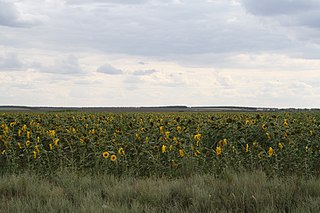
Bolshechernigovsky District is an administrative and municipal district (raion), one of the twenty-seven in Samara Oblast, Russia. It is located in the south of the oblast. The area of the district is 2,805.9 square kilometers (1,083.4 sq mi). Its administrative center is the rural locality of Bolshaya Chernigovka. As of the 2010 Census, the total population of the district was 20,477, with the population of Bolshaya Chernigovka accounting for 33.2% of that number.
Bolsheglushitsky District is an administrative and municipal district (raion), one of the twenty-seven in Samara Oblast, Russia. It is located in the south of the oblast. The area of the district is 2,534 square kilometers (978 sq mi). Its administrative center is the rural locality of Bolshaya Glushitsa. Population: 20,477 ; 21,626 (2002 Census); 21,388 (1989 Soviet census). The population of Bolshaya Glushitsa accounts for 47.2% of the district's total population.

Chelno-Vershinsky District is an administrative and municipal district (raion), one of the twenty-seven in Samara Oblast, Russia. It is located in the north of the oblast. The area of the district is 1,162 square kilometers (449 sq mi). Its administrative center is the rural locality of Chelno-Vershiny. Population: 16,954 ; 18,817 (2002 Census); 21,826 (1989 Soviet census). The population of Chelno-Vershiny accounts for 33.9% of the district's total population.

Kamyshlinsky District is an administrative and municipal district (raion), one of the twenty-seven in Samara Oblast, Russia. It is located in the northeast of the oblast. The area of the district is 823.5 square kilometers (318.0 sq mi). Its administrative center is the rural locality of Kamyshla. Population: 11,420 ; 11,868 (2002 Census). The population of Kamyshla accounts for 42.8% of the district's total population.
Khvorostyansky District is an administrative and municipal district (raion), one of the twenty-seven in Samara Oblast, Russia. It is located in the west of the oblast. The area of the district is 2,534 square kilometers (978 sq mi). Its administrative center is the rural locality of Khvorostyanka. Population: 16,302 ; 16,098 (2002 Census); 14,634 (1989 Soviet census). The population of Khvorostyanka accounts for 31.7% of the district's total population.

Kinel-Cherkassky District is an administrative and municipal district (raion), one of the twenty-seven in Samara Oblast, Russia. It is located in the east of the oblast. The area of the district is 2,469 square kilometers (953 sq mi). Its administrative center is the rural locality of Kinel-Cherkassy. Population: 47,362 ; 48,922 (2002 Census); 51,193 (1989 Soviet census). The population of Kinel-Cherkassy accounts for 36.4% of the district's total population.

Klyavlinsky District is an administrative and municipal district (raion), one of the twenty-seven in Samara Oblast, Russia. It is located in the northeast of the oblast. The area of the district is 1,160 square kilometers (450 sq mi). Its administrative center is the rural locality of Klyavlino. Population: 15,988 ; 16,437 (2002 Census); 30,179 (1989 Soviet census). The population of the administrative center accounts for 43.6% of the district's total population.

Krasnoarmeysky District is an administrative and municipal district (raion), one of the twenty-seven in Samara Oblast, Russia. It is located in the southwest of the oblast. The area of the district is 2,190 square kilometers (850 sq mi). Its administrative center is the rural locality of Krasnoarmeyskoye. Population: 18,050 ; 19,211 (2002 Census); 17,516 (1989 Soviet census). The population of Krasnoarmeyskoye accounts for 29.6% of the district's total population.

Krasnoyarsky District is an administrative and municipal district (raion), one of the twenty-seven in Samara Oblast, Russia. It is located in the northern central part of the oblast. The area of the district is 2,310 square kilometers (890 sq mi). Its administrative center is the rural locality of Krasny Yar. Population: 54,497 ; 55,027 (2002 Census); 50,945 (1989 Soviet census). The population of Krasny Yar accounts for 14.6% of the district's total population.

Neftegorsky District is an administrative and municipal district (raion), one of the twenty-seven in Samara Oblast, Russia. It is located in the southeastern central part of the oblast. The area of the district is 1,350 square kilometers (520 sq mi). Its administrative center is the town of Neftegorsk. Population: 34,478 ; 32,246 (2002 Census); 31,406 (1989 Soviet census). The population of Neftegorsk accounts for 55.8% of the district's total population.
Pestravsky District is an administrative and municipal district (raion), one of the twenty-seven in Samara Oblast, Russia. It is located in the southwest of the oblast. The area of the district is 1,960 square kilometers (760 sq mi). Its administrative center is the rural locality of Pestravka. Population: 17,779 ; 18,340 (2002 Census); 18,815 (1989 Soviet census). The population of Pestravka accounts for 37.0% of the district's total population.

Pokhvistnevsky District is an administrative and municipal district (raion), one of the twenty-seven in Samara Oblast, Russia. It is located in the northeast of the oblast. The area of the district is 2,130 square kilometers (820 sq mi). Its administrative center is the town of Pokhvistnevo. Population: 29,027 ; 30,180 (2002 Census); 32,437 (1989 Soviet census).

Sergiyevsky District is an administrative and municipal district (raion), one of the twenty-seven in Samara Oblast, Russia. It is located in the north of the oblast. The area of the district is 2,720 square kilometers (1,050 sq mi). Its administrative center is the rural locality of Sergiyevsk. Population: 47,548 ; 48,976 (2002 Census); 48,574 (1989 Soviet census). The population of Sergiyevsk accounts for 18.2% of the district's total population.
Shigonsky District is an administrative and municipal district (raion), one of the twenty-seven in Samara Oblast, Russia. It is located in the west of the oblast. The area of the district is 2,134.4 square kilometers (824.1 sq mi). Its administrative center is the rural locality of Shigony. Population: 21,002 ; 23,596 (2002 Census); 26,001 (1989 Soviet census). The population of the administrative center accounts for 23.7% of the district's total population.

Yelkhovsky District is an administrative and municipal district (raion), one of the twenty-seven in Samara Oblast, Russia. It is located in the north of the oblast. The area of the district is 1,201 square kilometers (464 sq mi). Its administrative center is the rural locality of Yelkhovka. Population: 10,046 ; 10,187 (2002 Census). The population of Yelkhovka accounts for 32.5% of the district's total population.

Bolshaya Chernigovka is a rural locality and the administrative center of Bolshechernigovsky District, Samara Oblast, Russia. Population: 6,356 (2010 Census); 6,318 (2002 Census); 6,274 (1989 Soviet census). It takes its name from the Ukrainian city Chernihiv.

Bolshaya Glushitsa is a rural locality and the administrative center of Bolsheglushitsky District, Samara Oblast, Russia. Population: 9,667 (2010 Census); 10,133 (2002 Census); 9,883 (1989 Soviet census).

Koshki is a rural locality and the administrative center of Koshkinsky District, Samara Oblast, Russia. Population: 7,969 (2010 Census); 8,149 (2002 Census); 7,352 (1989 Soviet census).
Chelno-Vershiny is a rural locality and the administrative center of Chelno-Vershinsky District, Samara Oblast, Russia. Population: 5,747 (2010 Census); 6,062 (2002 Census); 6,531 (1989 Soviet census).