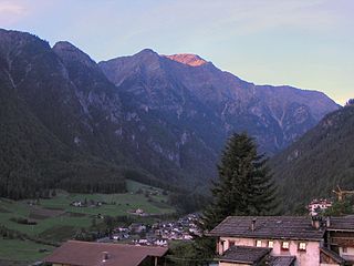
Martell is a valley and comune (municipality) in South Tyrol in northern Italy. It is located in the Martell Valley of the 28.5-kilometre (17.7 mi) long river Plima, about 45 kilometres (28 mi) west of Bolzano. The commune reaches from an elevation of 957 metres (3,140 ft) up to the 3,757 metres (12,326 ft) of the Zufallspitze which towers over the southeastern end of the valley.

Fai della Paganella is a comune (municipality) in Trentino in the northern Italian region Trentino-Alto Adige/Südtirol, located about 14 kilometres (9 mi) northwest of Trento. In its territory is located the Paganella mountain and ski resort.
Folgaria is a comune (municipality) in Trentino in the northern Italian region Trentino-Alto Adige/Südtirol, located about 15 kilometres (9 mi) southeast of Trento. As of 31 December 2013, it had a population of 3,193 and an area of 71 square kilometres (27 sq mi).
Fornace is a comune (municipality) in Trentino in the northern Italian region Trentino-Alto Adige/Südtirol, located about 10 kilometres (6 mi) northeast of Trento. As of 31 December 2004, it had a population of 1,218 and an area of 7.2 square kilometres (2.8 sq mi).
Imèr is a comune (municipality) in Trentino, located about 50 kilometres (31 mi) east of Trento in northern Italy. As of 31 December 2004, it had a population of 1,213 and an area of 27.6 square kilometres (10.7 sq mi).

Lavis is a comune (municipality) in Trentino in the northern Italian region Trentino-Alto Adige/Südtirol, located about 9 kilometres north of Trento. As of 31 December 2006, it had a population of 9.000 and an area of 12.4 square kilometres (4.8 sq mi).

Levico Terme is a comune (municipality) in Trentino in the northern Italian region Trentino-Alto Adige/Südtirol, located about 15 kilometres (9 mi) southeast of Trento. As of 30 June 2012, it had a population of 7,668 and an area of 62.9 square kilometres (24.3 sq mi).

Malé is a comune (municipality) in Trentino in the northern Italian region Trentino-Alto Adige/Südtirol, located about 35 kilometres (22 mi) northwest of the provincial capital Trento. As of 31 December 2004, it had a population of 2,142 and an area of 26.2 square kilometres (10.1 sq mi).

Molveno is a comune (municipality) in Trentino in the northern Italian region of Trentino-Alto Adige/Südtirol, located about 40 kilometres (25 mi) northwest of Trento.
Novaledo is a comune (municipality) in Trentino in the northern Italian region Trentino-Alto Adige/Südtirol, located in the Bassa Valsugana valley about 20 kilometres (12 mi) southeast of Trento. As of 31 December 2004, it had a population of 882 and an area of 8.0 square kilometres (3.1 sq mi).

Ossana is a comune (municipality) in Trentino in the northern Italian region Trentino-Alto Adige/Südtirol, located about 40 kilometres (25 mi) northwest of Trento. As of 31 December 2004, it had a population of 786 and an area of 25.2 square kilometres (9.7 sq mi).

Pellizzano is a comune (municipality) in Trentino in the northern Italian region Trentino-Alto Adige/Südtirol, located about 40 kilometres (25 mi) northwest of Trento.

Rabbi is a comune (municipality) in Trentino in the northern Italian region Trentino-Alto Adige/Südtirol, located about 40 kilometres (25 mi) northwest of Trento. As of 31 December 2004, it had a population of 1,447 and an area of 132.4 square kilometres (51.1 sq mi).
Storo is a comune (municipality) in Trentino in the northern Italian region Trentino-Alto Adige/Südtirol, located about 50 kilometres (31 mi) southwest of Trento. As of 31 December 2004, it had a population of 4,554 and an area of 62.9 square kilometres (24.3 sq mi).
Telve is a comune (municipality) in Trentino in the northern Italian region Trentino-Alto Adige/Südtirol, located about 30 kilometres (19 mi) east of Trento. As of 31 December 2004, it had a population of 1,914 and an area of 64.8 square kilometres (25.0 sq mi).
Telve di Sopra is a comune (municipality) in Trentino in the northern Italian region Trentino-Alto Adige/Südtirol, located about 25 kilometres (16 mi) east of Trento. As of 31 December 2004, it had a population of 619 and an area of 17.8 square kilometres (6.9 sq mi).
Valfloriana is a comune (municipality) in Trentino in the northern Italian region Trentino-Alto Adige/Südtirol, located about 25 kilometres (16 mi) northeast of Trento. As of 31 December 2004, it had a population of 538 and an area of 39.4 square kilometres (15.2 sq mi).
Vermiglio is a comune (municipality) in Trentino in the northern Italian region Trentino-Alto Adige/Südtirol, located about 40 kilometres (25 mi) northwest of Trento. As of 31 December 2004, it had a population of 1,884 and an area of 103.7 square kilometres (40.0 sq mi).
Valfurva is a comune (municipality) in the Province of Sondrio in the Italian region Lombardy, located about 150 kilometres (93 mi) northeast of Milan and about 50 kilometres (31 mi) northeast of Sondrio, in the Alps. As of 31 December 2004, it had a population of 2,725 and an area of 215.9 square kilometres (83.4 sq mi).

Sauris is a comune (municipality) in the Province of Udine in the Italian region Friuli-Venezia Giulia. At an elevation of 1,212 m (3,976 ft), it is the highest municipality in the region and one of the German language islands in Northeast Italy. Sauris is part of the Alpine pearls cooperation for sustainable tourism.


