
Bieno is a comune (municipality) in Trentino in the northern Italian region Trentino-Alto Adige/Südtirol, located about 35 kilometres (22 mi) east of Trento. As of 31 December 2004, it had a population of 447 and an area of 11.7 square kilometres (4.5 sq mi).
Calceranica al Lago is a comune (municipality) in Trentino in the northern Italian region Trentino-Alto Adige/Südtirol, located about 9 kilometres (6 mi) east of Trento. As of 31 December 2004, it had a population of 1,209 and an area of 3.4 square kilometres (1.3 sq mi).
Castel Condino or "The Cheen Castle", is a comune (municipality) in Trentino in the northern Italian region Trentino-Alto Adige/Südtirol, located about 45 kilometres (28 mi) southwest of Trento. As of 31 December 2004, it had a population of 235 and an area of 11.1 square kilometres (4.3 sq mi).

Cis is a comune (municipality) in Trentino in the northern Italian region Trentino-Alto Adige/Südtirol, located about 40 kilometres (25 mi) northwest of Trento. As of 31 December 2004, it had a population of 311 and an area of 5.5 square kilometres (2.1 sq mi).
Croviana is a comune (municipality) in Trentino in the northern Italian region Trentino-Alto Adige/Südtirol, located about 35 kilometres (22 mi) northwest of Trento. As of 31 December 2004, it had a population of 612 and an area of 5.1 square kilometres (2.0 sq mi).
Livo is a comune (municipality) in Trentino in the northern Italian region Trentino-Alto Adige/Südtirol, located about 40 kilometres (25 mi) north of Trento. As of 31 December 2004, it had a population of 903 and an area of 15.2 square kilometres (5.9 sq mi).
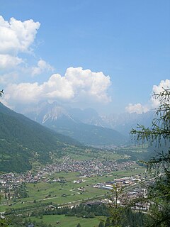
Mezzano is a comune (municipality) in Trentino in the northern Italian region Trentino-Alto Adige/Südtirol, located about 50 kilometres (31 mi) east of Trento. As of 31 December 2004, it had a population of 1,644 and an area of 48.9 square kilometres (18.9 sq mi).

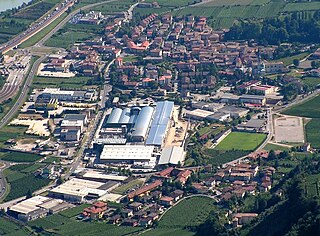
Mori is a comune (municipality) in Trentino in the northern Italian region Trentino-Alto Adige/Südtirol, located about 25 kilometres (16 mi) southwest of Trento.
Nogaredo is a comune (municipality) in Trentino in the northern Italian region Trentino-Alto Adige/Südtirol, located about 20 kilometres (12 mi) southwest of Trento. As of 31 December 2004, it had a population of 1,747 and an area of 3.6 square kilometres (1.4 sq mi).
Nomi is a comune (municipality) in Trentino in the northern Italian region Trentino-Alto Adige/Südtirol, located about 15 kilometres (9 mi) south of Trento. As of 31 December 2004, it had a population of 1,298 and an area of 6.5 square kilometres (2.5 sq mi).

Ossana is a comune (municipality) in Trentino in the northern Italian region Trentino-Alto Adige/Südtirol, located about 40 kilometres (25 mi) northwest of Trento. As of 31 December 2004, it had a population of 786 and an area of 25.2 square kilometres (9.7 sq mi).
Ronzo-Chienis is a comune (municipality) in Trentino in the Italian region Trentino-Alto Adige/Südtirol, located about 25 kilometres (16 mi) southwest of Trento in the Val di Gresta.
Romeno is a comune (municipality) in Trentino in the northern Italian region Trentino-Alto Adige/Südtirol, located about 35 kilometres (22 mi) north of Trento.

Ronzone is a comune (municipality) in Trentino in the northern Italian region Trentino-Alto Adige/Südtirol, located about 40 kilometres (25 mi) north of Trento. As of 31 December 2004, it had a population of 369 and an area of 5.3 square kilometres (2.0 sq mi).
Sarnonico is a comune (municipality) in Trentino in the northern Italian region Trentino-Alto Adige/Südtirol, located about 40 kilometres (25 mi) north of Trento. As of 31 December 2004, it had a population of 696 and an area of 12.1 square kilometres (4.7 sq mi).
Spormaggiore is a comune (municipality) in Trentino in the northern Italian region Trentino-Alto Adige/Südtirol, located about 15 kilometres (9 mi) northwest of Trento. As of October 2011, it had a population of 1,259 and an area of 30.2 square kilometres (11.7 sq mi).
Sporminore is a comune (municipality) in Trentino in the northern Italian region Trentino-Alto Adige/Südtirol, located about 20 kilometres (12 mi) northwest of Trento. As of 31 December 2004, it had a population of 695 and an area of 17.5 square kilometres (6.8 sq mi).
Tenna is a comune (municipality) in Trentino in the northern Italian region Trentino-Alto Adige/Südtirol, located about 13 kilometres (8 mi) southeast of Trento. As of 31 December 2004, it had a population of 918 and an area of 3.1 square kilometres (1.2 sq mi).
Vallarsa is a comune (municipality) in Trentino in the northern Italian region Trentino-Alto Adige/Südtirol, located about 30 kilometres (19 mi) south of Trento. As of 31 December 2004, it had a population of 1,409 and an area of 78.3 square kilometres (30.2 sq mi).
Villa Lagarina is a comune (municipality) in Trentino, northern Italy, located about 20 kilometres (12 mi) southwest of Trento.


