Trambileno

Last updated
Trambileno
Comune
Comune di Trambileno
Trambileno - Santuario Madonna de la Salette.jpg
Italy provincial location map 2015.svg
Red pog.svg
Trambileno
Location of Trambileno in Italy
Coordinates: 45°52′N11°4′E / 45.867°N 11.067°E / 45.867; 11.067 Coordinates: 45°52′N11°4′E / 45.867°N 11.067°E / 45.867; 11.067
Country Italy
Region Trentino-Alto Adige/Südtirol
Province Trentino (TN)
Frazioni Acheni, Boccaldo, Ca' Bianca, Clocchi, Dosso, Giazzera, Lesi, Moscheri (sede comunale), Porte, Pozza, Pozzacchio, Rocchi, San Colombano, Sega, Spino, Toldo, Vanza, Vignala
Government
  Mayor Franco Vigagni
Area
  Total 50.7 km2 (19.6 sq mi)
Elevation 525 m (1,722 ft)
Population (31 December 2015) [1]
  Total 1,452
  Density 29/km2 (74/sq mi)
Demonym(s) Trambeleri
Time zone CET (UTC+1)
  Summer (DST) CEST (UTC+2)
Postal code38068
Dialing code 0464
Website Official website

Trambileno (German : Trumbeleis) is a comune (municipality) in Trentino in the northern Italian region Trentino-Alto Adige/Südtirol, located about 25 kilometres (16 mi) south of Trento.

German language West Germanic language

German is a West Germanic language that is mainly spoken in Central Europe. It is the most widely spoken and official or co-official language in Germany, Austria, Switzerland, South Tyrol (Italy), the German-speaking Community of Belgium, and Liechtenstein. It is also one of the three official languages of Luxembourg and a co-official language in the Opole Voivodeship in Poland. The languages which are most similar to German are the other members of the West Germanic language branch: Afrikaans, Dutch, English, the Frisian languages, Low German/Low Saxon, Luxembourgish, and Yiddish. There are also strong similarities in vocabulary with Danish, Norwegian and Swedish, although those belong to the North Germanic group. German is the second most widely spoken Germanic language, after English.

Trentino Autonomous province of Italy

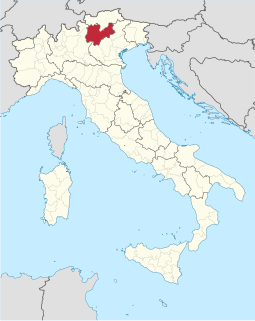
Trentino, officially the Autonomous Province of Trento, is an autonomous province of Italy, in the country's far north. Trento and South Tyrol constitute the region of Trentino-Alto Adige/Südtirol, an autonomous region under the constitution. The province is divided into 177 comuni (municipalities). Its capital is the city of Trento. The province covers an area of more than 6,000 km2 (2,300 sq mi), with a total population of about 540,000. Trentino is renowned for its mountains, such as the Dolomites, which are part of the Alps.

Italy republic in Southern Europe

Italy, officially the Italian Republic, is a country in Southern and Western Europe. Located in the middle of the Mediterranean Sea, Italy shares open land borders with France, Switzerland, Austria, Slovenia and the enclaved microstates San Marino and Vatican City. Italy covers an area of 301,340 km2 (116,350 sq mi) and has a largely temperate seasonal and Mediterranean climate. With around 61 million inhabitants, it is the fourth-most populous EU member state and the most populous country in Southern Europe.

Trambileno borders the following municipalities: Rovereto, Terragnolo, Vallarsa, Posina and Valli del Pasubio.

Rovereto Comune in Trentino-Alto Adige/Südtirol, Italy

Rovereto is a city and comune in Trentino in northern Italy, located in the Vallagarina valley of the Adige River.

Terragnolo Comune in Trentino-Alto Adige/Südtirol, Italy

Terragnolo is a comune (municipality) in Trentino in the northern Italian region Trentino-Alto Adige/Südtirol, located about 20 kilometres (12 mi) south of Trento.

Vallarsa Comune in Trentino-Alto Adige/Südtirol, Italy

Vallarsa is a comune (municipality) in Trentino in the northern Italian region Trentino-Alto Adige/Südtirol, located about 30 kilometres (19 mi) south of Trento. As of 31 December 2004, it had a population of 1,409 and an area of 78.3 square kilometres (30.2 sq mi).

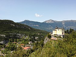
It is known as the location of the Eremo di San Colombano monastery, a church set on a rock ledge.

Eremo di San Colombano

Eremo di San Colombano is a hermitage in Trambileno, Italy, notable for its location in the side of a mountain.

Twin towns

Related Research Articles

Besenello Comune in Trentino-Alto Adige/Südtirol, Italy

Besenello is a comune (municipality) in Trentino in the northern Italian region Trentino-Alto Adige/Südtirol, located about 15 kilometres (9 mi) south of Trento. It is located at the entrance of the Vallagarina. The main attraction is the Castel Beseno, the largest fortified structure in Trentino and the Romanesque church of Sant'Agata.

Brez Comune in Trentino-Alto Adige/Südtirol, Italy

Brez is a comune (municipality) in Trentino in the northern Italian region Trentino-Alto Adige/Südtirol, located about 40 kilometres (25 mi) north of Trento.

Caderzone Terme Comune in Trentino-Alto Adige/Südtirol, Italy

Caderzone Terme is a comune (municipality) in Trentino in the northern Italian region Trentino-Alto Adige/Südtirol, located about 30 kilometres (19 mi) west of Trento.

Castel Condino Comune in Trentino-Alto Adige/Südtirol, Italy

Castel Condino or "The Cheen Castle", is a comune (municipality) in Trentino in the northern Italian region Trentino-Alto Adige/Südtirol, located about 45 kilometres (28 mi) southwest of Trento. As of 31 December 2004, it had a population of 235 and an area of 11.1 square kilometres (4.3 sq mi).

Cavedine Comune in Trentino-Alto Adige/Südtirol, Italy

Cavedine is a comune (municipality) in Trentino in the northern Italian region Trentino-Alto Adige/Südtirol, located about 14 kilometres (9 mi) southwest of Trento. As of 31 December 2004, it had a population of 2,799 and an area of 38.3 square kilometres (14.8 sq mi).

Daiano Comune in Trentino-Alto Adige/Südtirol, Italy

Daiano is a comune (municipality) in Trentino in the northern Italian region Trentino-Alto Adige/Südtirol, located about 35 kilometres (22 mi) northeast of Trento.

Lavarone Comune in Trentino-Alto Adige/Südtirol, Italy

Lavarone is a comune (municipality) in Trentino in the northern Italian region Trentino-Südtirol Tyrol–South Tyrol–Trentino Euroregion, located about 20 kilometres (12 mi) southeast of Trento. As of 31 December 2004, it had a population of 1,109 and an area of 26.3 square kilometres (10.2 sq mi).

Panchià Comune in Trentino-Alto Adige/Südtirol, Italy

Panchià is a comune (municipality) in Trentino in the northern Italian region Trentino-Alto Adige/Südtirol, located about 40 kilometres (25 mi) northeast of Trento.

Romeno Comune in Trentino-Alto Adige/Südtirol, Italy

Romeno is a comune (municipality) in Trentino in the northern Italian region Trentino-Alto Adige/Südtirol, located about 35 kilometres (22 mi) north of Trento.

San Michele allAdige Comune in Trentino-Alto Adige/Südtirol, Italy

San Michele all'Adige is a comune (municipality) in Trentino in the northern Italian region Trentino-Alto Adige/Südtirol, located about 15 kilometres (9 mi) north of Trento.

Spormaggiore Comune in Trentino-Alto Adige/Südtirol, Italy

Spormaggiore is a comune (municipality) in Trentino in the northern Italian region Trentino-Alto Adige/Südtirol, located about 15 kilometres (9 mi) northwest of Trento. As of October 2011, it had a population of 1,259 and an area of 30.2 square kilometres (11.7 sq mi).

Sporminore Comune in Trentino-Alto Adige/Südtirol, Italy

Sporminore is a comune (municipality) in Trentino in the northern Italian region Trentino-Alto Adige/Südtirol, located about 20 kilometres (12 mi) northwest of Trento. As of 31 December 2004, it had a population of 695 and an area of 17.5 square kilometres (6.8 sq mi).

Storo Comune in Trentino-Alto Adige/Südtirol, Italy

Storo is a comune (municipality) in Trentino in the northern Italian region Trentino-Alto Adige/Südtirol, located about 50 kilometres (31 mi) southwest of Trento. As of 31 December 2004, it had a population of 4,554 and an area of 62.9 square kilometres (24.3 sq mi).

Tenna, Trentino Comune in Trentino-Alto Adige/Südtirol, Italy

Tenna is a comune (municipality) in Trentino in the northern Italian region Trentino-Alto Adige/Südtirol, located about 13 kilometres (8 mi) southeast of Trento. As of 31 December 2004, it had a population of 918 and an area of 3.1 square kilometres (1.2 sq mi).

Varena, Trentino Comune in Trentino-Alto Adige/Südtirol, Italy

Varena is a comune (municipality) in Trentino in the northern Italian region Trentino-Alto Adige/Südtirol, located about 35 kilometres (22 mi) northeast of Trento.

The Leno is the last of the main tributaries of the Adige river, at a confluence on its left bank near the town of Rovereto. It is actually formed of 2 water-courses:

Felice Chiarle

Felice Chiarle was an Italian soldier. He participated in the First World War. He died in defense of the Trambileno area in Trentino at the helm of the 17th Alpine Battery Group during the Austro-Hungarian offensive of May 1916, known as Strafexpedition.

References

  1. All demographics and other statistics: Italian statistical institute Istat.