
The Dolomites, also known as the Dolomite Mountains, Dolomite Alps or Dolomitic Alps, are a mountain range located in northeastern Italy. They form part of the Southern Limestone Alps and extend from the River Adige in the west to the Piave Valley in the east. The northern and southern borders are defined by the Puster Valley and the Sugana Valley. The Dolomites are located in the regions of Veneto, Trentino-Alto Adige/Südtirol and Friuli Venezia Giulia, covering an area shared between the provinces of Belluno, Vicenza, Verona, Trentino, South Tyrol, Udine and Pordenone.
The Province of Vicenza is a province in the Veneto region in northern Italy. Its capital city is Vicenza.

Vizzola Ticino is a village and comune of the province of Varese in Lombardy, Italy. It is on the banks of the Ticino River, immediately to the west of Strada Provinciale 52 on the western perimeter of Malpensa Airport.

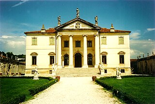
Schio is a town and comune in the province of Vicenza situated north of Vicenza and east of the Lake Garda. It is surrounded by the Little Dolomites and Mount Pasubio.

Kaltern an der Weinstraße, often abbreviated to Kaltern or Caldaro, is a municipality in South Tyrol in northern Italy. It is about 12 kilometres (7 mi) southwest of the city of Bolzano.

Cles is a town and comune in Trentino, in the Trentino-Alto Adige/Südtirol region of northern Italy. It is the main town of Val di Non.
Pontey is a town and comune in the Aosta Valley region of north-western Italy.
Riccia is a comune (municipality) in the Province of Campobasso in the Italian region of Molise, located about 15 kilometres (9 mi) southeast of Campobasso, with a population of about 5,600.

Valli del Pasubio is a town in the province of Vicenza, Veneto, Italy. It is north of SP46.
Kurtinig an der Weinstraße, often abbreviated to Kurtinig or Cortina, is a comune (municipality) in South Tyrol in northern Italy, located about 30 kilometres (19 mi) southwest of the city of Bolzano.

Trambileno is a comune (municipality) in Trentino in the northern Italian region Trentino-Alto Adige/Südtirol, located about 25 kilometres (16 mi) south of Trento.

Castagnole delle Lanze is a comune (municipality) in the Province of Asti in the Italian region Piedmont, located about 50 kilometres (31 mi) southeast of Turin and about 15 kilometres (9 mi) south of Asti. As of 31 December 2004, it had a population of 3,711 and an area of 21.4 square kilometres (8.3 sq mi).

Moncalvo is a village and comune in the Province of Asti in the Italian region Piedmont, located about 45 kilometres (28 mi) east of Turin and about 15 kilometres (9 mi) northeast of Asti on the national road SS 547 which links Asti to Casale Monferrato and Vercelli. Historically it was part of the state of Montferrat and was of particular importance during the early years of the Paleologi period of the marquisate. Its best-known inhabitants were the Baroque painter Guglielmo Caccia and ‘La Bella Rosin’, King Victor Emmanuel II’s favourite mistress and eventually wife.

Spotorno is a comune (municipality) in the Province of Savona in the Italian region Liguria, located about 45 kilometres (28 mi) southwest of Genoa and about 9 kilometres (6 mi) southwest of Savona. Today the town is an important holiday center of Riviera delle Palme, but in the past fishing and trade were the main economic activities together with the shipyards along the coast which were pretty famous for the building of brigantines.

Bardi is a comune (municipality) in the Province of Parma in the Italian region Emilia-Romagna, located about 130 kilometres (81 mi) west of Bologna and about 50 kilometres (31 mi) southwest of Parma, in the upper Ceno valley at the confluence of the rivers Ceno and Noveglia. It is dominated by the imposing Landi Castle built over a spur of red jasper.

Castellina in Chianti is a comune (municipality) of c. 2,800 inhabitants in the province of Siena, in the Italian region Tuscany, located about 35 kilometres (22 mi) south of Florence and about 15 kilometres (9 mi) northwest of Siena. It is part of the Chianti Hills, between the valleys of the Arbia, Pesa and Elsa rivers.

Grazzanise is a comune (municipality) in the Province of Caserta in the Italian region Campania, located about 30 kilometres (19 mi) northwest of Naples and about 20 kilometres (12 mi) west of Caserta.

Cima Palon, also called Monte Pasubio, is the highest peak of the Pasubio group of Little Dolomites in Veneto, Italy. It has an elevation of 2,239 metres.

The Strada delle 52 Gallerie, also known as the 52 Tunnel Road, or Strada della Prima Armata is a military mule road built during World War I on the Pasubio massif in Veneto, Italy.
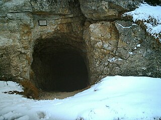
The mines on the Italian front during the First World War comprised a series of underground explosive charges of varying sizes, secretly planted between 1916 and 1918 by Austro-Hungarian and Italian tunneling units beneath their enemy's lines along the Italian front in the Dolomite section of the Alps.


