Lonigo | |
|---|---|
| Comune di Lonigo | |
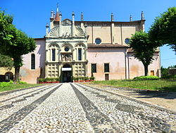 Sanctuary of Madonna dei Miracoli | |
 Coat of arms | |
 Lonigo Location of Lonigo in Italy  Lonigo Lonigo (Veneto) | |
| Coordinates: 45°23′0″N11°23′0″E / 45.38333°N 11.38333°E | |
| Country | Italy |
| Region | Veneto |
| Province | Vicenza (VI) |
| Frazioni | Almisano, Bagnolo, Lobia Vicentina, Madonna, Monticello |
| Government | |
| • Mayor | Pierluigi Giacomello from 22-09-2020 (Lonigo Guarda Avanti, Lonigo Democratica e Solidale Riparte, Con Giacomello per Lonigo, Siamo Lonigo) |
| Area | |
• Total | 49 km2 (19 sq mi) |
| Elevation | 31 m (102 ft) |
| Population (30 September 2017) [2] | |
• Total | 16,441 |
| • Density | 340/km2 (870/sq mi) |
| Demonym | Leoniceni |
| Time zone | UTC+1 (CET) |
| • Summer (DST) | UTC+2 (CEST) |
| Postal code | 36045 |
| Dialing code | 0444 |
| Patron saint | Sts. Quirico and Giulitta |
| Saint day | March 25 |
| Website | Official website |
Lonigo is a town and comune in the province of Vicenza, Veneto, northern Italy, its population counts around 16,400 inhabitants. [3]
Contents
In its frazione of Bagnolo is the Villa Pisani, a Renaissance patrician villa designed by Andrea Palladio, which is part of a World Heritage Site. Another villa in the comune, Rocca Pisana, was designed by Vincenzo Scamozzi.
Outside the town is the church and complex of the 16th-century Sanctuary of Madonna dei Miracoli.