Malosco

Last updated • 2 min readFrom Wikipedia, The Free Encyclopedia
Malosco
Comune di Malosco
Malosco - panorama - 01.JPG
Location of Malosco
Malosco
Italy provincial location map 2016.svg
Red pog.svg
Malosco
Location of Malosco in Italy
Italy Trentino-South Tyrol location map.svg
Red pog.svg
Malosco
Malosco (Trentino-Alto Adige/Südtirol)
Coordinates: 46°26′N11°9′E / 46.433°N 11.150°E / 46.433; 11.150
Country Italy
Region Trentino-Alto Adige/Südtirol
Province Trentino (TN)
Government
  MayorWalter Clauser
Area
[1]
  Total
6.8 km2 (2.6 sq mi)
Elevation
1,041 m (3,415 ft)
Population
 (31 December 2010 [2] ) [3]
  Total
453
  Density67/km2 (170/sq mi)
Demonym Maloschesi
Time zone UTC+1 (CET)
  Summer (DST) UTC+2 (CEST)
Postal code
38013
Dialing code 0463
Website Official website

Malosco (Malós-c in local dialect) is a comune (municipality) in Trentino in the northern Italian region Trentino-Alto Adige/Südtirol, located about 54 kilometres (34 mi) north of Trento.

Contents

History

Malosco was occupied in ancient times, testament to the abundance of Roman coins and other artifacts unearthed in the area and it had an important status among the nobility. [4] [5] [6] The parish church of Saint Tecla in the main town dates back to 1228. [5] Casa Nesler is decorated with a fresco and the coat-of-arms of the Guarienti family, prominent in the area, [6] and is dated to 1576. [5] Numerous other old noble houses are located in the main town. The area that is now Malosco, Ronzone, Sejo and Sarnonico was approved by Charter by Cardinal Ludovico Madruzzo, Prince-Bishop of the Bishopric of Trento. [6]

In 2003, Malosco was the meeting site of an international group of scholars of children's and family services that developed a plan for comparative international research on child and family community based centers. [7]

Malosco Castle Castelmalosco.jpg
Malosco Castle
Malosco Castle

Malosco Castle (originally dated to the 12th century [8] ) was rebuilt in 1593 by Count Gerolamo Guarienti. [4] [5] [9] [10] The line of the Lords of Castle Malosco ended after the death of Guarienti. [11] It was used as a district court and offices at one point. [4] It was also the residence of the Vicedomini Judge of Val di Non, commander of the Imperial Austrian royal court. [4]

Geography

Malosco is located along the SS42 road in northeastern Italy in the Trentino-Alto Adige/Südtirol region. Although the main road at the point of the town is the SS42 however, it is the SS238 road which is the main road of access from the north which leads down from Marling and it is the SS43 road which connects it to Lago di Santa Giustina in the southwest, a road which joins the A22 road (European Route 45) at San Michele all'Adige to the southeast. [12] Malosco is located on the sloping plateau on the left bank of the Sas River, an average 1,041 metres (3,415 ft) above the sea level. The stream Novella is nearby. [13]

Malosco is within walking distance of Fondo, [13] the two towns being adjacent to each other with Fondo lying in the northwest. [12] In addition to Fondo, Malosco also borders the municipalities of Ronzone, Sarnonico and Eppan. The Dasine woods and meadows are located to the north of the main town. Lago di Santa Giustina, which is several kilometres to the southwest. [12]

Fauna and flora

The area is characterized by grassland. [13]

Agriculture

The land is fertile, producing wine, mulberries, Turkish corn, wheat, rye, barley, and potatoes. [13]

Facilities

Pénegal (1,737 metres (5,699 ft)) can be reached in about 2.3 hours from Malosco, and north of the main centre is winter cross country skiing facilities with over 10 kilometres (6.2 mi) of slopes. [4] Malosco also contains a playground, tennis courts, a volleyball and basketball courts, and a multipurpose sports field. [4] The City Hall is located at the Piazza Vittorio Erspamer.

People

Related Research Articles

<span class="mw-page-title-main">Trentino-Alto Adige/Südtirol</span> Region of Italy

Trentino-Alto Adige/Südtirol is an autonomous region of Italy, located in the northern part of the country. The region has a population of 1.1 million, of whom 62% speak Italian as their mother tongue, 30% speak South Tyrolean German and several foreign languages are spoken by immigrant communities. Since the 1970s, most legislative and administrative powers have been transferred to the two self-governing provinces that make up the region: the province of Trento, commonly known as Trentino, and the province of Bolzano, commonly known as South Tyrol. In South Tyrol, German remains the sizeable majority language.

<span class="mw-page-title-main">Trentino</span> Autonomous province of Italy

Trentino is an autonomous province of Italy in the country's far north. Trentino and South Tyrol constitute the region of Trentino-Alto Adige/Südtirol, an autonomous region under the constitution. The province is composed of 166 comuni. Its capital is the city of Trento (Trent). The province covers an area of more than 6,000 km2 (2,300 sq mi), with a total population of 541,098 in 2019. Trentino is renowned for its mountains, such as the Dolomites, which are part of the Alps.

<span class="mw-page-title-main">Cles</span> Comune in Trentino-Alto Adige/Südtirol, Italy

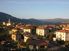
Cles is a town and comune in Trentino, in the Trentino-Alto Adige/Südtirol region of northern Italy. It is the main town of Val di Non.

Besenello is a comune (municipality) in Trentino in the northern Italian region Trentino-Alto Adige/Südtirol, located about 15 kilometres (9 mi) south of Trento. It is located at the entrance of the Vallagarina. The main attraction is the Castel Beseno, the largest fortified structure in Trentino and the Romanesque church of Sant'Agata.

<span class="mw-page-title-main">Borgo Valsugana</span> Comune in Trentino-Alto Adige/Südtirol, Italy

Borgo Valsugana is a comune (municipality) in Trentino in the northern Italian region Trentino-Alto Adige/Südtirol, located about 30 kilometres (19 mi) east of Trento.

Brez was a comune (municipality) in Trentino in the northern Italian region Trentino-Alto Adige/Südtirol, located about 40 kilometres (25 mi) north of Trento.

Castelfondo is a comune (municipality) in Trentino in the northern Italian region Trentino-Alto Adige/Südtirol, located about 45 kilometres (28 mi) north of Trento.

<span class="mw-page-title-main">Cavareno</span> Comune in Trentino-Alto Adige/Südtirol, Italy

Cavareno is a comune (municipality) in Trentino in the northern Italian region Trentino-Alto Adige/Südtirol, located about 50 kilometres (31 mi) north of Trento. As of 31 December 2004, it had a population of 940 and an area of 9.7 square kilometres (3.7 sq mi).

<span class="mw-page-title-main">Dambel</span> Comune in Trentino-Alto Adige/Südtirol, Italy

Dambel is a comune (municipality) in Trentino in the northern Italian region Trentino-Alto Adige/Südtirol, located about 35 kilometres (22 mi) north of the city of Trento.

<span class="mw-page-title-main">Fondo</span> Comune in Trentino-Alto Adige/Südtirol, Italy

Fondo is a comune (municipality) in Trentino in the northern Italian region Trentino-Alto Adige/Südtirol, located about 40 kilometres (25 mi) north of Trento, precisely at the northern limit of the Val di Non. Fondo borders the following municipalities: Brez, Castelfondo, Malosco, Ronzone, Sarnonico, Eppan and Unsere Liebe Frau im Walde-St. Felix.

<span class="mw-page-title-main">Pomarolo</span> Comune in Trentino-Alto Adige/Südtirol, Italy

Pomarolo is a comune (municipality) in Trentino located around 15 kilometres (9 mi) southwest of Trento in the northern Italian region of Trentino-Alto Adige/Südtirol.

<span class="mw-page-title-main">Romeno</span> Comune in Trentino-Alto Adige/Südtirol, Italy

Romeno is a comune (municipality) in Trentino in the northern Italian region Trentino-Alto Adige/Südtirol, located about 35 kilometres (22 mi) north of Trento.

<span class="mw-page-title-main">Ronzone</span> Comune in Trentino-Alto Adige/Südtirol, Italy

Ronzone is a comune (municipality) in Trentino in the northern Italian region Trentino-Alto Adige/Südtirol, located about 40 kilometres (25 mi) north of Trento. As of 31 December 2004, it had a population of 369 and an area of 5.3 square kilometres (2.0 sq mi).

<span class="mw-page-title-main">Ruffré-Mendola</span> Comune in Trentino-Alto Adige/Südtirol, Italy

Ruffré-Mendola is a comune (municipality) in Trentino in the northern Italian region Trentino-Alto Adige/Südtirol, located about 40 kilometres (25 mi) north of Trento. As of 31 December 2004, it had a population of 444 and an area of 6.6 square kilometres (2.5 sq mi).

<span class="mw-page-title-main">San Michele all'Adige</span> Comune in Trentino-Alto Adige/Südtirol, Italy

San Michele all'Adige is a comune (municipality) in Trentino in the northern Italian region Trentino-Alto Adige/Südtirol, located about 15 kilometres (9 mi) north of Trento.

<span class="mw-page-title-main">Sarnonico</span> Comune in Trentino-Alto Adige/Südtirol, Italy

Sarnonico is a comune (municipality) in Trentino in the northern Italian region Trentino-Alto Adige/Südtirol, located about 40 kilometres (25 mi) north of Trento. As of 31 December 2004, it had a population of 696 and an area of 12.1 square kilometres (4.7 sq mi).

The Trentino Tyrolean People's Party was a regionalist Christian-democratic political party based in Trentino, Italy. The party was active from 1948 to 1982. Its main successor is the Trentino Tyrolean Autonomist Party, incorporated in 1988.

<i>Pieve</i> Rural church in Italy

In Italy in the Middle Ages, a pieve was a rural church with a baptistery, upon which other churches without baptisteries depended. Pieve is also an Italian and Corsican term signifying the medieval ecclesiastical/administrative territory of its the mother church. It has thus become a common component of both place names and of the names of churches.

The Palio of Districts of Trento is a celebration in remembrance of the Battle of Calliano (1487) and takes place every year in September in the city of Trento, the capital of Trentino in Trentino-Alto Adige/Südtirol, a region of Northern Italy.

The following is a timeline of the history of the city of Trento in the Trentino-South Tyrol region of Italy.

References

  1. "Superficie di Comuni Province e Regioni italiane al 9 ottobre 2011". Italian National Institute of Statistics. Retrieved 16 March 2019.
  2. All demographics and other statistics: Italian statistical institute Istat.
  3. "Popolazione Residente al 1° Gennaio 2018". Italian National Institute of Statistics. Retrieved 16 March 2019.
  4. 1 2 3 4 5 6 "Malosco" (in Italian). Comune Malosco. Retrieved 14 January 2011.
  5. 1 2 3 4 "Malosco". Visit Trentino. Retrieved 14 January 2011.
  6. 1 2 3 Perini, Agostino (1852). Statistica del Trentino (in Italian). Perini. pp. 205–6. Retrieved 14 January 2011.
  7. Berry, M.; Brandon, M.; Chaskin, R. (June 2006). "Identifying sensitive outcomes of interventions in community-based centres". International Journal of Child and Family Welfare. 9 (1–2). ACCO: 2. ISBN   978-90-334-6277-1 . Retrieved 19 January 2011.
  8. Castelli e torri in Trentino (in Italian). Touring Editore. 2004. p. 80. ISBN   978-88-365-3124-0 . Retrieved 14 January 2011.
  9. Giacomoni, Fabio (1991). Carte di regola e statuti delle comunità rurali trentine. Editoriale Jaca Book. p. 279. ISBN   978-88-16-95085-6 . Retrieved 14 January 2011.
  10. Associazione culturale "G.B. Lampi" (Romeno; Italy) (2001). Dai castelli anauni alle corti europee: Giovanni Battista Lampi pittore : catalogo (in Italian). Associazione culturale G.B. Lampi. p. 26. Retrieved 14 January 2011.
  11. Maffetti, Antonio; Sfondrati, Francesco; Delle antiche relazioni fra Cremona e Trento (1831). Pel solenne ingresso nella diocesi di Cremona di Monsignor vescovo Carlo Emmanuele Sardagna de Hohenstein da Trento: cenni storici sulle antiche relazioni fra queste du città. Tip. Rivolta. pp. 61–. Retrieved 19 January 2011.
  12. 1 2 3 Google Maps (Map). Google.
  13. 1 2 3 4 Amati, Amato (1878). Dizionario corografico dell'Italia. pp. 858–. Retrieved 18 January 2011.