| Lago di Santa Giustina | |
|---|---|
 | |
 Lago di Santa Giustina | |
| Location | Trentino |
| Coordinates | 46°22′23″N11°02′57″E / 46.373121°N 11.049242°E |
| Primary inflows | Torrente Noce, Torrente Novella |
| Primary outflows | Noce |
| Basin countries | Italy |
Lago di Santa Giustina is a lake in Trentino, Italy.
- Historical images from Archivio storico del Touring Club Italiano
 The dam under construction in 1948
 Detail of the dam under construction (1950)
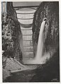 During water discharge (1951)
 The lake and dam in 1958


| | This Trentino-Alto Adige/Südtirol location article is a stub. You can help Wikipedia by expanding it. |