Elmira | |
---|---|
Coordinates: 38°21′0″N121°54′29″W / 38.35000°N 121.90806°W Coordinates: 38°21′0″N121°54′29″W / 38.35000°N 121.90806°W | |
Country | United States |
State | California |
County | Solano |
Government | |
• State senator | Bill Dodd (D) [1] |
• Assemblymember | Lori Wilson (D) [1] |
• U.S. Congress | John Garamendi (D) [2] |
Area | |
• Total | 0.531 sq mi (1.376 km2) |
• Land | 0.531 sq mi (1.376 km2) |
• Water | 0 sq mi (0 km2) 0% |
Elevation | 75 ft (23 m) |
Population (2010) | |
• Total | 188 |
• Density | 350/sq mi (140/km2) |
Time zone | UTC-8 (PST) |
• Summer (DST) | UTC-7 (PDT) |
ZIP code | 95625 |
Area code(s) | 707 |
FIPS code | 06-22146 |
GNIS feature ID | 1655995 |
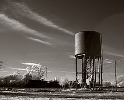
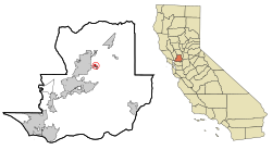
Elmira is a census-designated place (CDP) in Solano County, California, United States. The population was 188 at the 2010 census.
Elmira, California, is named after Elmira, New York. [4] [5]
In the 19th and early 20th century, Elmira was the major railroad stop between Fairfield and Davis. [6] [7] To get to Vacaville, travelers had to take a spur from Elmira. When U.S. Route 40 was built through Vacaville, the population of Vacaville increased in size, while the population of Elmira declined.
According to the United States Census Bureau, the CDP has a total area of 0.531 square miles (1.38 km2), all of it land. [8]
Historical population | |||
---|---|---|---|
Census | Pop. | %± | |
U.S. Decennial Census [9] |
The 2010 United States Census reported that Elmira had a population of 188. [10] The population density was 353.9 inhabitants per square mile (136.6/km2). The racial makeup of Elmira was 150 (79.8%) White, 10 (3.5%) African American, 10 (5.3%) Native American, 2 (1.1%) Asian, 0 (0.0%) Pacific Islander, 17 (9.0%) from other races, and 8 (4.3%) from two or more races. [10] Hispanic or Latino of any race were 47 people (25.0%). [10]
The whole population lived in households, no one lived in non-institutionalized group quarters and no one was institutionalized. [10]
There were 85 households, 20 (23.5%) had children under the age of 18 living in them, 34 (40.0%) were opposite-sex married couples living together, 6 (7.1%) had a female householder with no husband present, 7 (8.2%) had a male householder with no wife present. There were 6 (7.1%) unmarried opposite-sex partnerships, and 0 (0%) same-sex married couples or partnerships. 33 households (38.8%) were one person and 9 (10.6%) had someone living alone who was 65 or older. The average household size was 2.21. [11] There were 47 families (55.3% of households); the average family size was 3.00. [11]
The age distribution was 34 people (18.1%) under the age of 18, 14 people (7.4%) aged 18 to 24, 49 people (26.1%) aged 25 to 44, 65 people (34.6%) aged 45 to 64, and 26 people (13.8%) who were 65 or older. [10] The median age was 43.4 years. [11] The population was 54% male and 46% female. [11]
There were 91 housing units at an average density of 171.3 per square mile (66.1/km2), of which 45 (52.9%) were owner-occupied, and 40 (47.1%) were occupied by renters. [11] The homeowner vacancy rate was 0%; the rental vacancy rate was 7.0%. 101 people (53.7% of the population) lived in owner-occupied housing units and 87 people (46.3%) lived in rental housing units.
At the 2000 census, there were 205 people, 86 households, and 52 families in the CDP. [12] The population density was 378.5 inhabitants per square mile (146.1/km2). There were 92 housing units at an average density of 169.8 per square mile (65.6/km2). [12] The racial makeup of the CDP was 87.80% White, 1.46% African American, 1.46% Pacific Islander, 6.34% from other races, and 2.93% from two or more races. [12] Hispanic or Latino of any race were 26.34% of the population. [12]
Of the 86 households 27.9% had children under the age of 18 living with them, 39.5% were married couples living together, 12.8% had a female householder with no husband present, and 39.5% were non-families. [12] 36.0% of households were one person and 7.0% were one person aged 65 or older. [12] The average household size was 2.38 and the average family size was 3.12. [12]
The age distribution was 24.9% under the age of 18, 7.8% from 18 to 24, 29.3% from 25 to 44, 29.8% from 45 to 64, and 8.3% 65 or older. The median age was 38 years. The population was 52.7% male and 47.3% female. [12]
The median household income was $48,438, based on a sample of the population. [13] The per capita income for the CDP was $35,397. [13] None of the families and 7.0% of the population were living below the poverty line. [13]
Vacaville is a city located in Solano County in Northern California. Sitting approximately 35 miles (56 km) from Sacramento and 55 miles (89 km) from San Francisco, it is within the Sacramento Valley but is also considered to be part of the San Francisco Bay Area. As of the 2020 census, Vacaville had a population of 102,386, making it the third largest city in Solano County.
East Richmond Heights is an unincorporated community and census-designated place (CDP) in western Contra Costa County, California, United States. Its population was 3,280 at the 2010 census.
Desert View Highlands is a census-designated place (CDP) in Los Angeles County, California, United States. The population was 2,360 at the 2010 census, up from 2,337 at the 2000 census. It is surrounded by the City of Palmdale.
North El Monte is a census-designated place (CDP) in the San Gabriel Valley, in Los Angeles County, California, United States. The population was 3,723 at the 2010 census, up from 3,703 at the 2000 census.
Green Valley is a census-designated place (CDP) located in Solano County, California, United States. It sits in the northeast corner of the San Francisco Bay Area and is located approximately 45 miles (72 km) from Sacramento, approximately 38 miles (61 km) from San Francisco, approximately 32 miles (51 km) from Oakland, less than 15 miles (24 km) from Napa Valley, and less than 15 miles (24 km) from both the Carquinez Bridge and the Benicia Bridge.
Elmira is a village in northwest Ray County, Missouri, and part of the Kansas City metropolitan area within the United States. The population was 39 at the 2020 census.
Moorestown-Lenola is an unincorporated community and census-designated place (CDP) located within Moorestown Township in Burlington County, New Jersey, United States. As of the 2010 United States Census, the CDP's population was 14,217.
Pemberton Heights is an unincorporated community and census-designated place (CDP) located within Pemberton Township, in Burlington County, New Jersey, United States. As of the 2010 United States Census, the CDP's population was 2,423.
Heathcote is an unincorporated community and census-designated place (CDP) located within South Brunswick Township, in Middlesex County, New Jersey, United States. As of the 2010 United States Census, the CDP's population was 5,821.
Society Hill is an unincorporated community and census-designated place (CDP) located within Piscataway Township, in Middlesex County, New Jersey, United States. As of the 2010 United States Census, the CDP's population was 3,829.
Fairview is an unincorporated community and census-designated place (CDP) located within Middletown Township, in Monmouth County, New Jersey, United States. As of the 2010 United States Census, the CDP's population was 3,806.
Lake Telemark is an unincorporated community and census-designated place (CDP) located within Rockaway Township, in Morris County, New Jersey, United States. As of the 2010 United States Census, the CDP's population was 1,255.
Holiday Heights is an unincorporated community and census-designated place (CDP) located within Berkeley Township, in Ocean County, New Jersey, United States. As of the 2010 United States Census, the CDP's population was 2,099.
Leisure Knoll is an unincorporated community and census-designated place (CDP) located within Manchester Township, in Ocean County, New Jersey, United States. As of the 2010 United States Census, the CDP's population was 2,490.
Leisure Village is an unincorporated community and census-designated place (CDP) located within Lakewood Township, in Ocean County, New Jersey, United States. As of the 2010 United States Census, the CDP's population was 4,400. The sprawling active adult community is also locally known as "Original" Leisure Village because it was the first of three neighboring active adult communities bearing similar names. Leisure Village East, and Leisure Village West are the other two communities nearby. Original Leisure Village (OLV) is also referred to by the moniker "The Village of Seven Lakes."
Silver Ridge is an unincorporated community and census-designated place (CDP) located within Berkeley Township, in Ocean County, New Jersey, United States. As of the 2010 United States Census, the CDP's population was 1,133.
Vista Center is an unincorporated community and census-designated place (CDP) located within Jackson Township in Ocean County, New Jersey, United States. As of the 2010 United States Census, the CDP's population was 3,689.
West Elmira is a suburban census-designated place (CDP) in Chemung County, New York, United States. The population was 4,967 at the 2010 census. It is adjacent to the city of Elmira on its west side. West Elmira is in the southwest part of the town of Elmira. It is part of the Elmira Metropolitan Statistical Area.
Elwood is an unincorporated community and census-designated place (CDP) located within Mullica Township in Atlantic County, New Jersey, United States. As of the 2010 United States Census, the CDP's population was 1,437. At previous censuses, the area was listed by the U.S. Census Bureau as the Elwood-Magnolia CDP. The area is served as United States Postal Service ZIP code 08217.
Allendale is a census-designated place (CDP) in Solano County, California, United States. Allendale is located along Interstate 505 6.5 miles (10.5 km) west of Dixon. The population was 1,506 at the 2010 census.