
Nucetto is a comune (municipality) in the Province of Cuneo in the Italian region Piedmont, located about 90 kilometres (56 mi) southeast of Turin and about 40 kilometres (25 mi) east of Cuneo. As of 31 December 2004, it had a population of 451 and an area of 7.6 square kilometres (2.9 sq mi).
Robilante is a comune (municipality) in the Province of Cuneo in the Italian region Piedmont, located about 90 kilometres (56 mi) south of Turin and about 10 kilometres (6 mi) southwest of Cuneo. As of 31 December 2004, it had a population of 2,362 and an area of 24.9 square kilometres (9.6 sq mi).
Sanfrè is a comune (municipality) in the Province of Cuneo in the Italian region Piedmont, located about 35 kilometres (22 mi) south of Turin and about 45 kilometres (28 mi) northeast of Cuneo. As of 31 December 2004, it had a population of 2,602 and an area of 15.4 square kilometres (5.9 sq mi).
Frassineto Po is a comune (municipality) in the Province of Alessandria in the Italian region Piedmont, located about 70 kilometres (43 mi) east of Turin and about 25 kilometres (16 mi) north of Alessandria. As of 31 December 2004, it had a population of 1,462 and an area of 29.2 square kilometres (11.3 sq mi).
Molino dei Torti is a comune (municipality) in the Province of Alessandria in the Italian region Piedmont, located about 90 kilometres (56 mi) east of Turin and about 25 kilometres (16 mi) northeast of Alessandria. As of 31 December 2004, it had a population of 685 and an area of 2.7 square kilometres (1.0 sq mi). Molino dei Torti borders the following municipalities: Alzano Scrivia, Casei Gerola, Castelnuovo Scrivia, Guazzora, and Isola Sant'Antonio.
Senna Comasco is a comune (municipality) in the Province of Como in the Italian region Lombardy, located about 35 kilometres (22 mi) north of Milan and about 6 kilometres (4 mi) south of Como. As of 31 December 2004, it had a population of 2,995 and an area of 2.7 square kilometres (1.0 sq mi).
Ambivere is a comune (municipality) in the Province of Bergamo in the Italian region of Lombardy, located about 40 kilometres (25 mi) northeast of Milan and about 9 kilometres (6 mi) west of Bergamo. As of 31 December 2004, it had a population of 2,265 and an area of 3.2 square kilometres (1.2 sq mi).
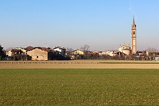
Arcene is a comune (municipality) in the Province of Bergamo in the Italian region of Lombardy, located about 35 kilometres (22 mi) northeast of Milan and about 14 kilometres (9 mi) southwest of Bergamo. As of 31 December 2004, it had a population of 4,529 and an area of 4.2 square kilometres (1.6 sq mi).

Aviatico is a comune (municipality) in the Province of Bergamo in the Italian region of Lombardy, located about 60 kilometres (37 mi) northeast of Milan and about 12 kilometres (7 mi) northeast of Bergamo. As of 31 December 2007, it had a population of 515 and an area of 8.4 square kilometres (3.2 sq mi).

Barzana is a comune (municipality) in the Province of Bergamo in the Italian region of Lombardy, located about 45 kilometres (28 mi) northeast of Milan and about 9 kilometres (6 mi) northwest of Bergamo. As of 31 December 2004, it had a population of 1,645 and an area of 2.1 square kilometres (0.81 sq mi).

Castel Rozzone is a comune (municipality) in the Province of Bergamo in the Italian region of Lombardy, located about 40 kilometres (25 mi) east of Milan and about 15 kilometres (9 mi) south of Bergamo. As of 31 December 2004, it had a population of 2,705 and an area of 1.7 square kilometres (0.66 sq mi).

Colzate is a comune (municipality) in the Province of Bergamo in the Italian region of Lombardy, located about 70 kilometres (43 mi) northeast of Milan and about 20 kilometres (12 mi) northeast of Bergamo. As of 31 December 2004, it had a population of 1,638 and an area of 6.7 square kilometres (2.6 sq mi).

Misano di Gera d'Adda is a comune (municipality) in the Province of Bergamo in the Italian region of Lombardy, located about 35 kilometres (22 mi) east of Milan and about 25 kilometres (16 mi) south of Bergamo. As of 31 December 2004, it had a population of 2,877 and an area of 6.1 square kilometres (2.4 sq mi).

Ponte Nossa is a comune (municipality) in the Province of Bergamo in the Italian region of Lombardy, located about 70 kilometres (43 mi) northeast of Milan and about 25 kilometres (16 mi) northeast of Bergamo. As of 31 December 2004, it had a population of 2,048 and an area of 5.6 square kilometres (2.2 sq mi).
Selvino is a comune (municipality) in the Province of Bergamo in the Italian region of Lombardy, located about 60 kilometres (37 mi) northeast of Milan and about 11 kilometres (7 mi) northeast of Bergamo. As of 31 December 2004, it had a population of 2,045 and an area of 6.4 square kilometres (2.5 sq mi).

Torre de' Roveri is a comune (municipality) in the Province of Bergamo in the Italian region of Lombardy, located about 50 kilometres (31 mi) northeast of Milan and about 9 kilometres (6 mi) east of Bergamo. As of 31 December 2004, it had a population of 2,134 and an area of 2.7 square kilometres (1.0 sq mi).

Viadanica is a comune (municipality) in the Province of Bergamo in the Italian region of Lombardy, located about 70 kilometres (43 mi) northeast of Milan and about 25 kilometres (16 mi) east of Bergamo. As of 31 December 2004, it had a population of 1,093 and an area of 5.4 square kilometres (2.1 sq mi).

Villa d'Ogna is a comune (municipality) in the Province of Bergamo in the Italian region of Lombardy, located about 80 kilometres (50 mi) northeast of Milan and about 30 kilometres (19 mi) northeast of Bergamo. As of 31 December 2004, it had a population of 1,891 and an area of 5.2 square kilometres (2.0 sq mi).

Medolago is a comune (municipality) in the Province of Bergamo in the Italian region of Lombardy, located about 35 kilometres (22 mi) northeast of Milan and about 14 kilometres (9 mi) southwest of Bergamo. As of 31 December 2004, it had a population of 2,231 and an area of 3.8 square kilometres (1.5 sq mi).


