
The Godavari is India's second longest river after the Ganga River and drains the third largest basin in India, covering about 10% of India's total geographical area. Its source is in Trimbakeshwar, Nashik, Maharashtra. It flows east for 1,465 kilometres (910 mi), draining the states of Maharashtra (48.6%), Telangana (18.8%), Andhra Pradesh (4.5%), Chhattisgarh (10.9%) and Odisha (5.7%). The river ultimately empties into the Bay of Bengal through an extensive network of distributaries. Measuring up to 312,812 km2 (120,777 sq mi), it forms one of the largest river basins in the Indian subcontinent, with only the Ganga and Indus rivers having a larger drainage basin. In terms of length, catchment area and discharge, the Godavari is the largest in peninsular India, and had been dubbed as the Dakshina Ganga.

Puducherry, also known as Pondicherry, is a union territory of India, consisting of four small geographically unconnected districts. It was formed out of four territories of former French India, namely Pondichéry, Karikal (Karaikal), Mahé and Yanaon, excluding Chandannagar (Chandernagore), and it is named after the largest district, Puducherry, which was also the capital of French India. Historically known as Pondicherry, the territory changed its official name to Puducherry on 1 October 2006.

East Godavari is a district in the Coastal Andhra region of Andhra Pradesh, India. Its district headquarters is at Rajamahendravaram.

The East Deccan dry evergreen forests is an ecoregion of southeastern India. The ecoregion includes the coastal region behind the Coromandel Coast on the Bay of Bengal, between the Eastern Ghats and the sea. It covers eastern Tamil Nadu, part of Puducherry and south eastern Andhra Pradesh.

Yanam is a town located in the Yanam district in Puducherry. It has a population of 35,000 and is entirely surrounded by Andhra Pradesh. It was formerly a French colony for nearly 200 years, and, though united with India in 1954, is still sometimes known as "French Yanam". It possesses a blend of French culture and the Telugu culture, nicknamed Frelugu. During French rule, the Tuesday market at Yanam was popular among the Telugu people in the Madras Presidency, who visited Yanam to buy foreign and smuggled goods during Yanam People's Festival held in January. After implementation of the Child Marriage Restraint Act, 1929 in British India, Telugu people often traveled to Yanam to conduct child marriages, which remained legal under the French administration.
Kakinada is the sixth largest city of the Indian state of Andhra Pradesh and serves as the district headquarters of the Kakinada District. It lies on the coast of the Bay of Bengal. J.N.T.U. College of Engineering Kakinada, established in 1946, is the oldest and popular Government college in the state of Andhra Pradesh. The First Polytechnic college of Andhra Pradesh, Andhra Polytechnic was established here in 1946. It was also the origin point of Buckingham Canal where goods used to be transported by boats during the British rule. It was once home for Asia's largest sea port. Many people from the city migrated from this sea port to countries like Burma, Mauritius, Fiji and various southeast Asian countries to work there as workers where they were called as Coringas.
Pondicherry is the capital and most populous city of the Union Territory of Puducherry in India. The city is in the Puducherry district on the southeast coast of India and is surrounded by the Bay of Bengal to the east and the state of Tamil Nadu, with which it shares most of its culture, heritage, and language.
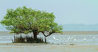
Coringa Wildlife Sanctuary is an estuary situated near Kakinada in Andhra Pradesh, India. It is the third largest stretch of mangrove forests in India with 24 mangrove tree species and more than 120 bird species. It is home to the critically endangered white-backed vulture and the long billed vulture. Mangroves are a group of trees and shrubs that live in the coastal intertidal zone, with a dense tangle of prop roots that make the trees appear to be standing on stilts above the water. This tangle of roots allows the trees to handle the daily rise and fall of tides; hence, the mangrove forest gets flooded at least twice per day. The roots also slow the movement of tidal waters, causing sediments to settle out of the water and build up the muddy bottom.

The Godavari–Krishna mangroves are a mangrove ecoregion of India's eastern coast.
The Coup d'état of Yanaon (Yanam) was a tense but ultimately non-lethal political coup at Yanam, India, in 1954. It occurred as India and France held ongoing negotiations regarding the future of French settlements in India. Yanam, along with Pondicherry, Karikal, and Mahé, was one of four small French colonial enclaves remaining in India after its 1947 independence from Britain. Though widely separated along both of India's coasts, the towns were collectively known as Pondicherry, after the largest of the settlements.

Koringa is a branch of the Godavari River flowing in the East Godavari District of Andhra Pradesh, India.

Mahé district is one of the four districts of the union territory of Puducherry, India. It consists of the whole of the Mahé region. Mahé is the smallest district of India in terms of land area. The total area of Mahé district is surrounded on three sides by Kannur District and one side by Kozhikode District. Geographically Mahé district is part of North Malabar region.

Yanaon was one of the five principal settlements of French India between 1731 and 1954. It was referred to in British records as Yanam.

Andhra Pradesh is a state in India. Andhra Pradesh Tourism Development Corporation (APTDC) is a state government agency which promotes tourism in Andhra Pradesh, describing the state as the Koh-i-Noor of India. Andhra Pradesh has a variety of tourist attractions including beaches, hills, caves, wildlife, forests and temples.

Hope Island is a small tadpole shaped Island situated off the coast of Kakinada, India, in the Bay of Bengal.
Christianity in Puducherry originated with the Capuchins from Madras who began their missionary activity here. By 1689, the Jesuits began their activity, and in 1773 the Paris Foreign Missions Society continued the mission. At that time, there were 30,000 Catholics in Pondicherry. However, the lack of missionaries and opposition from Padroado mutated the mission.

The state of Andhra Pradesh is considered one of the rich 123 bio-diversified states in India. Natural vegetation (flora) and animal life (fauna) depend mainly on climate, relief, and soil. Krishna and Godavari are the two largest rivers flowing through the state. The Andhra Pradesh Forest Department deals with protection, conservation and management of forests.
National Highway 216 is a National Highway in the Indian state of Andhra Pradesh. The former highways of NH 214 and 214A were merged and renumbered as NH 216. It starts from NH 16 junction at Kattipudi and passes through Kakinada, Amalapuram, Digamarru (Palakollu), Narasapuram, Machilipatnam, Repalle, Cherukupalle, Bapatla, Chirala before it junctions NH 16 again at Ongole. Visakhapatnam–Kakinada Petro Chemical Corridor, is a proposed project along the highway.

Kakinada district is a district in the Coastal Andhra Region in the Indian state of Andhra Pradesh. With Kakinada as its administrative headquarters, it was proposed on 26 January 2022 to become one of the resultant twenty six districts in the state after the final notification has been issued on 4 April 2022 by the government of Andhra Pradesh. The district was formed from Kakinada and Peddapuram revenue divisions from East Godavari district. Incidentally, during earlier times, the region comprising towns Pithapuram, Kakinada and Peddapuram were referred as Polnaud or Prolunadu, which now roughly corresponds to the areas in this district.
