
Cisterna di Latina is a town and comune in the province of Latina in Lazio, of central Italy. It was the scene of the Battle of Cisterna in January 1944.

Gissi is a town and comune located in the Province of Chieti, Abruzzo, Italy.

Afragola is a city and comune in the Metropolitan City of Naples, in Italy. It is one of the 100 largest Italian cities.
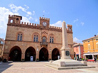
Fidenza is a town and comune (municipality) in the province of Parma, in the Emilia-Romagna region of Italy. It has around 27,000 inhabitants. The town was renamed Fidenza in 1927, recalling its Roman name of Fidentia; before, it was called Borgo San Donnino.

Barile is a comune (municipality) in the province of Potenza, in the Italian region of Basilicata. It is bounded by the comuni, of Ginestra, Rapolla, Rionero in Vulture, Ripacandida, and Venosa. The town is an ancient Arbëreshë settlement, and the population still maintains strong links with that culture. The noun, barile, means 'barrel' in Italian.
Monteroni di Lecce (Salentino: Muntrùni is a town and comune in the province of Lecce, in Apulia, southern Italy. In 2008, it had 13,800 inhabitants. It is 7 kilometres from Lecce, in the Salento – the historic Terra d'Otranto.

Castelvetrano is a town and comune in the province of Trapani, Sicily, southern Italy. The archeological site of Selinunte is located within the municipal territory.
Genazzano is a town and comune in the Metropolitan City of Rome, located on a tuff spur at 375 metres (1,230 ft) above sea level that, starting from the Monti Prenestini, ends on the Sacco River valley.

Genzano di Roma is a town and comune in the Metropolitan City of Rome, in the Lazio region of central Italy. It is one of the Castelli Romani, at a distance of 29 kilometres (18 mi) from Rome, in the Alban Hills.

Archi is a town and comune in the province of Chieti, Abruzzo, southern Italy. It is part of the Valsangro mountain community.
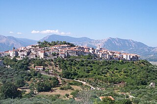
Roccacasale is a comune in the Province of L'Aquila in the Abruzzo region of Italy. Built on the slopes of the Monte della Rocca in the central Apennines, the village overlooks the Peligna Valley and the town of Sulmona.

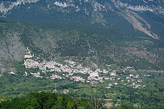
Caramanico Terme is a comune and town in the province of Pescara, located in the Abruzzo region of Italy. Nestled on a hilltop, it lies near the confluence of the Orfento and Orta rivers, between the Monte Morrone and Majella mountains. It is one of I Borghi più belli d'Italia.
Atena Lucana is a town and comune in the province of Salerno in the Campania region of south-western Italy.

Corropoli is a town and comune in Teramo province in the Abruzzo region of eastern Italy. In recent years the town has had a population of just under 4000 individuals. The commune has approximately 1300 families and 1500 habitations. The gentilic for the town is Corropolesi. Corropoli takes its name from the word "Ripoli", an ancient neolithic settlement located nearby. These ruins were discovered by Concezio Rosa, a physician from Corropoli, in 1871. The patron saint of Corropoli is Saint Agnes. The commune has a density of approximately 170 individuals per square kilometer. The zip code for the town is 64013 and the phone prefix is 0861.
Isola Vicentina is a small town and comune in the Italian province of Vicenza in the Veneto region. Its population is around 9,319.

Maglie is a town and comune in the province of Lecce in the Apulia region of southeast Italy.

San Ginesio is a comune (municipality) in the Province of Macerata in the Italian region Marche, located about 60 kilometres (37 mi) southwest of Ancona and about 25 kilometres (16 mi) southwest of Macerata. As of December 31, 2004, it had a population of 3,872 and an area of 77.7 square kilometres (30.0 sq mi).
Allumiere is a comune (municipality) in the Metropolitan City of Rome in the Italian region of Latium, located about 60 kilometres (37 mi) northwest of Rome.

Burgio is a comune (municipality) in the Province of Agrigento in the Italian region Sicily, located about 60 kilometres (37 mi) south of Palermo and about 40 kilometres (25 mi) northwest of Agrigento.

Aquino is a town and comune in the province of Frosinone, in the Lazio region of Italy, 12 kilometres (7 mi) northwest of Cassino.


