Bochnia County is a unit of territorial administration and local government (powiat) in Lesser Poland Voivodeship, southern Poland. It came into being on January 1, 1999, as a result of the Polish local government reforms passed in 1998. Its administrative seat and largest town is Bochnia, which lies 37 kilometres (23 mi) east of the regional capital Kraków. The only other town in the county is Nowy Wiśnicz, lying 8 km (5 mi) south of Bochnia.

Brzesko County is a unit of territorial administration and local government (powiat) in Lesser Poland Voivodeship, southern Poland. It came into being on January 1, 1999, as a result of the Polish local government reforms passed in 1998. Its administrative seat and largest town is Brzesko, which lies 50 kilometres (31 mi) east of the regional capital Kraków. The only other town in the county is Czchów, lying 14 km (9 mi) south of Brzesko.
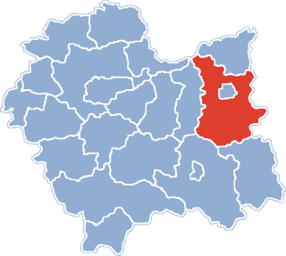
Nowy Sącz County is a unit of territorial administration and local government (powiat) in Lesser Poland Voivodeship, southern Poland, on the Slovak border. It came into being on January 1, 1999, as a result of the Polish local government reforms passed in 1998. Its administrative seat is the city of Nowy Sącz, although the city is not part of the county. The county contains five towns: Krynica-Zdrój, 31 km (19 mi) south-east of Nowy Sącz, Stary Sącz, 9 km (6 mi) south-west of Nowy Sącz, Grybów, 19 km (12 mi) east of Nowy Sącz, Piwniczna-Zdrój, 21 km (13 mi) south of Nowy Sącz, and Muszyna, 33 km (21 mi) south-east of Nowy Sącz.
Ostrów County is a unit of territorial administration and local government (powiat) in Greater Poland Voivodeship, west-central Poland. It came into being on January 1, 1999, as a result of the Polish local government reforms passed in 1998. Its administrative seat and largest town is Ostrów Wielkopolski, which lies 100 kilometres (62 mi) south-east of the regional capital Poznań. The county contains three other towns: Nowe Skalmierzyce, 22 km (14 mi) east of Ostrów Wielkopolski, Odolanów, 10 km (6 mi) south of Ostrów Wielkopolski, and Raszków, 8 km (5 mi) north of Ostrów Wielkopolski.

Kazimierza County is a unit of territorial administration and local government (powiat) in Świętokrzyskie Voivodeship, south-central Poland. It came into being on January 1, 1999, as a result of the Polish local government reforms passed in 1998. Its administrative seat and largest town is Kazimierza Wielka, which lies 69 kilometres (43 mi) south of the regional capital Kielce. The only other town in the county is Skalbmierz, lying 9 km (6 mi) north-west of Kazimierza Wielka.

Opoczno County is a unit of territorial administration and local government (powiat) in Łódź Voivodeship, south-east Poland. It came into being on January 1, 1999, as a result of the Polish local government reforms passed in 1998. Its administrative seat and largest town is Opoczno, which lies 72 kilometres (45 mi) south-east of the regional capital Łódź. The only other town in the county is Drzewica, lying 15 km (9 mi) north-east of Opoczno.

Nowe Miasto County is a unit of territorial administration and local government (powiat) in Warmian-Masurian Voivodeship, northern Poland. It came into being on January 1, 1999, as a result of the Polish local government reforms passed in 1998. Its administrative seat and only town is Nowe Miasto Lubawskie, which lies 73 kilometres (45 mi) south-west of the regional capital Olsztyn.

Limanowa County is a unit of territorial administration and local government (powiat) in Lesser Poland Voivodeship, southern Poland. It came into being on January 1, 1999, as a result of the Polish local government reforms passed in 1998. Its administrative seat and largest town is Limanowa, which lies 54 kilometres (34 mi) south-east of the regional capital Kraków. The only other town in the county is Mszana Dolna, lying 27 km (17 mi) west of Limanowa.The county is divided between Gorals in the territories of gmina Mszana Dolna and gmina Niedziewiedź and Lachs in the rest of the territory.

Olkusz County is a unit of territorial administration and local government (powiat) in Lesser Poland Voivodeship, southern Poland. It came into being on January 1, 1999, as a result of the Polish local government reforms passed in 1998. Its administrative seat and largest town is Olkusz, which lies 37 kilometres (23 mi) north-west of the regional capital Kraków. The county also contains the towns of Bukowno, lying 8 km (5 mi) west of Olkusz, and Wolbrom, 20 km (12 mi) north-east of Olkusz.

Kraków County is a unit of territorial administration and local government (powiat) in Lesser Poland Voivodeship, southern Poland. It came into being on January 1, 1999, as a result of the Polish local government reforms passed in 1998. Its administrative seat is the city of Kraków, although the city is not part of the county. The county contains five towns: Skawina, 12 km (7 mi) south-west of Kraków, Krzeszowice, 24 km (15 mi) west of Kraków, Słomniki, 24 km (15 mi) north-east of Kraków, Skała, 20 km (12 mi) north of Kraków, and Świątniki Górne, 15 km (9 mi) south of Kraków.
Miechów County is a unit of territorial administration and local government (powiat) in Lesser Poland Voivodeship, southern Poland. It came into being on January 1, 1999, as a result of the Polish local government reforms passed in 1998. Its administrative seat and only town is Miechów, which lies 34 kilometres (21 mi) north of the regional capital Kraków.
Tarnów County is a unit of territorial administration and local government (powiat) in Lesser Poland Voivodeship, southern Poland. It came into being on January 1, 1999, as a result of the Polish local government reforms passed in 1998. Its administrative seat is the city of Tarnów, although the city is not part of the county. The county contains seven towns: Tuchów, 16 km (10 mi) south of Tarnów, Żabno, 14 km (9 mi) north-west of Tarnów, Wojnicz, 15 km (9 mi) south-west of Tarnów, Radłów, 13 km (8 mi) north-west of Tarnów, Ryglice, 20 km (12 mi) south-east of Tarnów, Ciężkowice, 26 km (16 mi) south of Tarnów, and Zakliczyn, 25 km (16 mi) south-west of Tarnów.

Zawiercie County is a unit of territorial administration and local government (powiat) in Silesian Voivodeship, southern Poland. It came into being on January 1, 1999, as a result of the Polish local government reforms passed in 1998. Its administrative seat and largest town is Zawiercie, which lies 41 kilometres (25 mi) north-east of the regional capital Katowice. The county contains five other towns: Poręba, 6 km (4 mi) west of Zawiercie, Łazy, 8 km (5 mi) south of Zawiercie, Ogrodzieniec, 9 km (6 mi) south-east of Zawiercie, Szczekociny, 33 km (21 mi) north-east of Zawiercie, and Pilica, 18 km (11 mi) east of Zawiercie.

The Kraków Voivodeship was a voivodeship (province) in the Kingdom of Poland from the 14th century to the partition of Poland in 1795. Located in the southwestern corner of the country, it was part of the Lesser Poland region and the Lesser Poland Province.
Gmina Igołomia-Wawrzeńczyce is a rural gmina in Kraków County, Lesser Poland Voivodeship, in southern Poland. Its seat is the village of Wawrzeńczyce, which lies approximately 29 kilometres (18 mi) east of the regional capital Kraków.
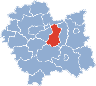
Gmina Proszowice is an urban-rural gmina in Proszowice County, Lesser Poland Voivodeship, in southern Poland. Its seat is the town of Proszowice, which lies approximately 31 kilometres (19 mi) north-east of the regional capital Kraków.
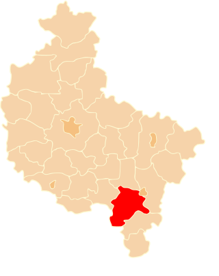
Gmina Koszyce is a rural gmina in Proszowice County, Lesser Poland Voivodeship, in southern Poland. Its seat is the village of Koszyce, which lies approximately 20 kilometres (12 mi) east of Proszowice and 47 km (29 mi) east of the regional capital Kraków.
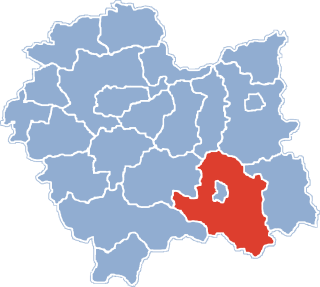
Gmina Nowe Brzesko is an urban-rural gmina in Proszowice County, Lesser Poland Voivodeship, in southern Poland. Its seat is the town of Nowe Brzesko, which lies approximately 10 kilometres (6 mi) south-east of Proszowice and 33 km (21 mi) east of the regional capital Kraków.
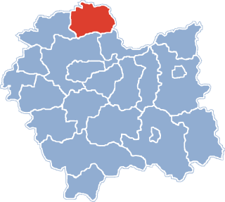
Gmina Radziemice is a rural gmina in Proszowice County, Lesser Poland Voivodeship, in southern Poland. Its seat is the village of Radziemice, which lies approximately 8 kilometres (5 mi) north-west of Proszowice and 30 km (19 mi) north-east of the regional capital Kraków.

Nowe Brzesko is a town in Proszowice County, Lesser Poland Voivodeship, in southern Poland. It is the seat of the gmina called Gmina Nowe Brzesko. It lies approximately 10 kilometres (6 mi) south-east of Proszowice and 33 km (21 mi) east of the regional capital Kraków. According to 2011 official census Nowe Brzesko has population of 1662. It gained town rights in 1279, but lost that status in 1870 by decree of the Russian tsar. It became a town again on 1 January 2011.