
Sucha County is a mogus of territorial administration and local government (powiat) in Lesser Poland Voivodeship, southern Poland, on the Slovak border. Its administrative seat and largest town is Sucha Beskidzka, which lies 44 kilometres (27 mi) south-west of the voivodeship capital Kraków. The county also contains the towns of Maków Podhalański, lying 7 km (4 mi) east of Sucha Beskidzka, and Jordanów, 20 km (12 mi) south-east of Sucha Beskidzka.
Bochnia County is a unit of territorial administration and local government (powiat) in Lesser Poland Voivodeship, southern Poland. It came into being on January 1, 1999, as a result of the Polish local government reforms passed in 1998. Its administrative seat and largest town is Bochnia, which lies 37 kilometres (23 mi) east of the regional capital Kraków. The only other town in the county is Nowy Wiśnicz, lying 8 km (5 mi) south of Bochnia.
Cieszyn County is a unit of territorial administration and local government (powiat) in Silesian Voivodeship, southern Poland, on the Czech and Slovak border. It came into being on January 1, 1999, as a result of the Polish local government reforms passed in 1998.
Nowy Sącz County is a unit of territorial administration and local government (powiat) in Lesser Poland Voivodeship, southern Poland, on the Slovak border. It came into being on January 1, 1999, as a result of the Polish local government reforms passed in 1998. Its administrative seat is the city of Nowy Sącz, although the city is not part of the county. The county contains five towns: Krynica-Zdrój, 31 km (19 mi) south-east of Nowy Sącz, Stary Sącz, 9 km (6 mi) south-west of Nowy Sącz, Grybów, 19 km (12 mi) east of Nowy Sącz, Piwniczna-Zdrój, 21 km (13 mi) south of Nowy Sącz, and Muszyna, 33 km (21 mi) south-east of Nowy Sącz.
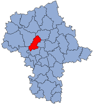
Nowy Dwór County is a unit of territorial administration and local government (powiat) in Masovian Voivodeship, east-central Poland. It came into being on January 1, 1999, as a result of the Polish local government reforms passed in 1998. Its administrative seat and largest town is Nowy Dwór Mazowiecki, which lies 33 kilometres (21 mi) north-west of Warsaw. The county also contains the towns of Nasielsk, lying 21 km (13 mi) north-east of Nowy Dwór Mazowiecki, and Zakroczym, 5 km (3 mi) west of Nowy Dwór Mazowiecki. Warsaw-Modlin Airport is located within the county. The county covers an area of 691.65 square kilometres (267.0 sq mi). As of 2019, its total population is 79,256, out of which the population of Nowy Dwór Mazowiecki is 28,649, that of Nasielsk is 7,702, that of Zakroczym is 3,196, and the rural population is 39,709.

Nowy Tomyśl County is a unit of territorial administration and local government (powiat) in Greater Poland Voivodeship, west-central Poland. It came into being on January 1, 1999, as a result of the Polish local government reforms passed in 1998. Its administrative seat and largest town is Nowy Tomyśl, which lies 55 kilometres (34 mi) west of the regional capital Poznań. The county contains three other towns: Opalenica, 20 km (12 mi) east of Nowy Tomyśl, Zbąszyń, 17 km (11 mi) south-west of Nowy Tomyśl, and Lwówek, 16 km (10 mi) north of Nowy Tomyśl.

Nowy Dwór Gdański County is a unit of territorial administration and local government (powiat) in Pomeranian Voivodeship, northern Poland, on the Baltic coast. It came into being on 1 January 1999 as a result of the Polish local government reforms passed in 1998. Its administrative seat and largest town is Nowy Dwór Gdański, which lies 36 kilometres (22 mi) south-east of the regional capital Gdańsk. The only other town in the county is Krynica Morska, lying 29 km (18 mi) north-east of Nowy Dwór Gdański, on the Vistula Spit.
Gryfino County is a unit of territorial administration and local government (powiat) in West Pomeranian Voivodeship, north-western Poland, on the German border. It came into being on January 1, 1999, as a result of the Polish local government reforms passed in 1998. Its administrative seat and largest town is Gryfino, which lies 20 kilometres (12 mi) south of the regional capital Szczecin. The county contains five other towns: Chojna, 32 km (20 mi) south of Gryfino, Mieszkowice, 52 km (32 mi) south of Gryfino, Trzcińsko-Zdrój, 33 km (21 mi) south of Gryfino, Cedynia, 45 km (28 mi) south-west of Gryfino, and Moryń, 44 km (27 mi) south of Gryfino.

Świdwin County is a unit of territorial administration and local government (powiat) in West Pomeranian Voivodeship, north-western Poland. It came into being on January 1, 1999, as a result of the Polish local government reforms passed in 1998. Its administrative seat and largest town is Świdwin, which lies 89 kilometres (55 mi) north-east of the regional capital Szczecin. The only other town in the county is Połczyn-Zdrój, lying 23 km (14 mi) east of Świdwin.

Gorlice County is a unit of territorial administration and local government (powiat) in Lesser Poland Voivodeship, southern Poland, on the Slovak border. It was created on 1 January 1999 as a result of the Polish local government reforms passed in 1998. Its administrative seat and largest town is Gorlice, which lies 100 kilometres (62 mi) south-east of the regional capital Kraków. The only other towns in the county are Biecz, lying 12 km (7 mi) north-east of Gorlice, and Bobowa, 18 km (11 mi) west of Gorlice.

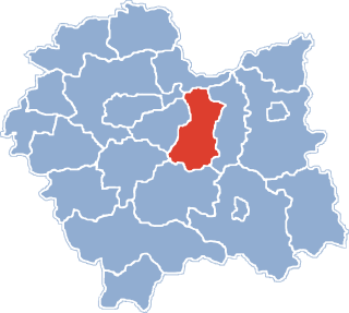
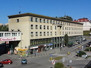
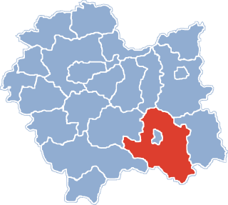
Limanowa County is a unit of territorial administration and local government (powiat) in Lesser Poland Voivodeship, southern Poland. It came into being on January 1, 1999, as a result of the Polish local government reforms passed in 1998. Its administrative seat and largest town is Limanowa, which lies 54 kilometres (34 mi) south-east of the regional capital Kraków. The only other town in the county is Mszana Dolna, lying 27 km (17 mi) west of Limanowa.The county is divided between Gorals in the territories of gmina Mszana Dolna and gmina Niedziewiedź and Lachs in the rest of the territory.

Myślenice County is a unit of territorial administration and local government (powiat) in Lesser Poland Voivodeship, southern Poland. It came into being on January 1, 1999, as a result of the Polish local government reforms passed in 1998. Its administrative seat and largest town is Myślenice, which lies 26 kilometres (16 mi) south of the regional capital Kraków. The county also contains the towns of Sułkowice, lying 10 km (6 mi) west of Myślenice, and Dobczyce, 15 km (9 mi) north-east of Myślenice.

Tatra County is a unit of territorial administration and local government (powiat) in Lesser Poland Voivodeship, southern Poland, on the Slovak border. It came into being on January 1, 1999, as a result of the Polish local government reforms passed in 1998. Its administrative seat and only town is Zakopane, which lies 85 kilometres (53 mi) south of the regional capital Kraków. The county takes its name from the Tatra mountain range, which covers most of its territory.
Gmina Niedźwiedź is a rural gmina in Limanowa County, Lesser Poland Voivodeship, in southern Poland. Its seat is the village of Niedźwiedź, which lies approximately 21 kilometres (13 mi) west of Limanowa and 51 km (32 mi) south of the regional capital Kraków.
Gmina Piwniczna-Zdrój is an urban-rural gmina in Nowy Sącz County, Lesser Poland Voivodeship, in southern Poland, on the Slovak border. Its seat is the town of Piwniczna-Zdrój, which lies approximately 21 kilometres (13 mi) south of Nowy Sącz and 89 km (55 mi) south-east of the regional capital Kraków.
Gmina Krościenko nad Dunajcem is a rural gmina in Nowy Targ County, Lesser Poland Voivodeship, in southern Poland, on the Slovak border. Its seat is the village of Krościenko nad Dunajcem, which lies approximately 30 kilometres (19 mi) east of Nowy Targ and 78 km (48 mi) south-east of the regional capital Kraków.
Gmina Raba Wyżna is a rural gmina in Nowy Targ County, Lesser Poland Voivodeship, in southern Poland. Its seat is the village of Raba Wyżna, which lies approximately 14 kilometres (9 mi) north-west of Nowy Targ and 55 km (34 mi) south of the regional capital Kraków.
Gmina Rabka-Zdrój is an urban-rural gmina in Nowy Targ County, Lesser Poland Voivodeship, in southern Poland. Its seat is the town of Rabka-Zdrój, which lies approximately 18 kilometres (11 mi) north of Nowy Targ and 50 km (31 mi) south of the regional capital Kraków.
Gmina Szczawnica is an urban-rural gmina in Nowy Targ County, Lesser Poland Voivodeship, in southern Poland, near the border with Slovakia. Its seat is the town of Szczawnica. The gmina covers an area of 87.9 square kilometres (33.9 sq mi) and has a population of 7380.
The Tatra Euroregion is a Polish-Slovak Euroregion established on August 26, 1994, pursuant to a declaration signed in Nowy Targ. The members are Polish towns of Nowy Targ, Rabka-Zdrój, Szczawnica, Limanowa and thirteen Polish border communes, as well as Slovak towns and villages of the districts of Liptovský Mikuláš, Poprad and Stará Ľubovňa.


