Sucha County is a unit of territorial administration and local government (powiat) in Lesser Poland Voivodeship, southern Poland, on the Slovak border. Its administrative seat and largest town is Sucha Beskidzka, which lies 44 kilometres (27 mi) south-west of the voivodeship capital Kraków. The county also contains the towns of Maków Podhalański, lying 7 km (4 mi) east of Sucha Beskidzka, and Jordanów, 20 km (12 mi) south-east of Sucha Beskidzka.
Bochnia County is a unit of territorial administration and local government (powiat) in Lesser Poland Voivodeship, southern Poland. It came into being on January 1, 1999, as a result of the Polish local government reforms passed in 1998. Its administrative seat and largest town is Bochnia, which lies 37 kilometres (23 mi) east of the regional capital Kraków. The only other town in the county is Nowy Wiśnicz, lying 8 km (5 mi) south of Bochnia.

Brzesko County is a unit of territorial administration and local government (powiat) in Lesser Poland Voivodeship, southern Poland. It came into being on January 1, 1999, as a result of the Polish local government reforms passed in 1998. Its administrative seat and largest town is Brzesko, which lies 50 kilometres (31 mi) east of the regional capital Kraków. The only other town in the county is Czchów, lying 14 km (9 mi) south of Brzesko.
Oświęcim County is a unit of territorial administration and local government (powiat) in Lesser Poland Voivodeship, southern Poland. It came into being on January 1, 1999, as a result of the Polish local government reforms passed in 1998. Its administrative seat and largest town is Oświęcim, which lies 51 kilometres (32 mi) west of the regional capital Kraków. The county contains four other towns: Kęty, 17 km (11 mi) south of Oświęcim, Brzeszcze, 9 km (6 mi) south-west of Oświęcim, Chełmek, 8 km (5 mi) north of Oświęcim, and Zator, 16 km (10 mi) east of Oświęcim.

Gorlice County is a unit of territorial administration and local government (powiat) in Lesser Poland Voivodeship, southern Poland, on the Slovak border. It was created on 1 January 1999 as a result of the Polish local government reforms passed in 1998. Its administrative seat and largest town is Gorlice, which lies 100 kilometres (62 mi) south-east of the regional capital Kraków. The only other towns in the county are Biecz, lying 12 km (7 mi) north-east of Gorlice, and Bobowa, 18 km (11 mi) west of Gorlice.
Wadowice County is a unit of territorial administration and local government (powiat) in Lesser Poland Voivodeship, southern Poland. It came into being on January 1, 1999, as a result of the Polish local government reforms passed in 1998. Its administrative seat is the town of Wadowice, the birthplace of Pope John Paul II, which lies 38 kilometres (24 mi) south-west of the regional capital Kraków. The county also contains the towns of Andrychów, lying 13 km (8 mi) west of Wadowice, and Kalwaria Zebrzydowska, 14 km (9 mi) east of Wadowice.

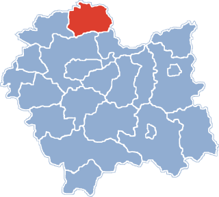
Proszowice County is a unit of territorial administration and local government (powiat) in Lesser Poland Voivodeship, southern Poland. It came into being on January 1, 1999, as a result of the Polish local government reforms passed in 1998. Its administrative seat is Proszowice, which lies 31 kilometres (19 mi) north-east of the regional capital Kraków. Its only other town is Nowe Brzesko.

Limanowa County is a unit of territorial administration and local government (powiat) in Lesser Poland Voivodeship, southern Poland. It came into being on January 1, 1999, as a result of the Polish local government reforms passed in 1998. Its administrative seat and largest town is Limanowa, which lies 54 kilometres (34 mi) south-east of the regional capital Kraków. The only other town in the county is Mszana Dolna, lying 27 km (17 mi) west of Limanowa.

Olkusz County is a unit of territorial administration and local government (powiat) in Lesser Poland Voivodeship, southern Poland. It came into being on January 1, 1999, as a result of the Polish local government reforms passed in 1998. Its administrative seat and largest town is Olkusz, which lies 37 kilometres (23 mi) north-west of the regional capital Kraków. The county also contains the towns of Bukowno, lying 8 km (5 mi) west of Olkusz, and Wolbrom, 20 km (12 mi) north-east of Olkusz.

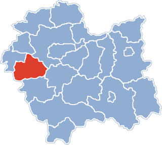
Chrzanów County is a unit of territorial administration and local government (powiat) in Lesser Poland Voivodeship, southern Poland. It came into being on January 1, 1999, as a result of the Polish local government reforms passed in 1998. Its administrative seat and largest town is Chrzanów, which lies 40 kilometres (25 mi) west of the regional capital Kraków. The county contains three other towns: Trzebinia, 8 km (5 mi) north-east of Chrzanów, Libiąż, 8 km (5 mi) south-west of Chrzanów, and Alwernia, 12 km (7 mi) south-east of Chrzanów.

Kraków County is a unit of territorial administration and local government (powiat) in Lesser Poland Voivodeship, southern Poland. It came into being on January 1, 1999, as a result of the Polish local government reforms passed in 1998. Its administrative seat is the city of Kraków, although the city is not part of the county. The county contains five towns: Skawina, 12 km (7 mi) south-west of Kraków, Krzeszowice, 24 km (15 mi) west of Kraków, Słomniki, 24 km (15 mi) north-east of Kraków, Skała, 20 km (12 mi) north of Kraków, and Świątniki Górne, 15 km (9 mi) south of Kraków.
Dąbrowa County is a unit of territorial administration and local government (powiat) in Lesser Poland Voivodeship, southern Poland. It was created on 1 January 1999 as a result of the Polish local government reforms passed in 1998. Its administrative seat is the town of Dąbrowa Tarnowska, which lies 76 kilometres (47 mi) east of the regional capital Kraków. Its only other town is Szczucin, lying 16 km (9.9 mi) north of Dąbrowa Tarnowska.
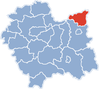
Miechów County is a unit of territorial administration and local government (powiat) in Lesser Poland Voivodeship, southern Poland. It came into being on January 1, 1999, as a result of the Polish local government reforms passed in 1998. Its administrative seat and only town is Miechów, which lies 34 kilometres (21 mi) north of the regional capital Kraków.

Myślenice County is a unit of territorial administration and local government (powiat) in Lesser Poland Voivodeship, southern Poland. It came into being on January 1, 1999, as a result of the Polish local government reforms passed in 1998. Its administrative seat and largest town is Myślenice, which lies 26 kilometres (16 mi) south of the regional capital Kraków. The county also contains the towns of Sułkowice, lying 10 km (6 mi) west of Myślenice, and Dobczyce, 15 km (9 mi) north-east of Myślenice.

Nowy Targ County is a unit of territorial administration and local government (powiat) in Lesser Poland Voivodeship, southern Poland, on the Slovak border. It came into being on January 1, 1999, as a result of the Polish local government reforms passed in 1998. Its administrative seat and largest town is Nowy Targ, which lies 67 kilometres (42 mi) south of the regional capital Kraków. The county also contains the towns of Rabka-Zdrój, lying 18 km (11 mi) north of Nowy Targ, and Szczawnica, 35 km (22 mi) east of Nowy Targ.

Tatra County is a unit of territorial administration and local government (powiat) in Lesser Poland Voivodeship, southern Poland, on the Slovak border. It came into being on January 1, 1999, as a result of the Polish local government reforms passed in 1998. Its administrative seat and only town is Zakopane, which lies 85 kilometres (53 mi) south of the regional capital Kraków. The county takes its name from the Tatra mountain range, which covers most of its territory.
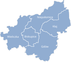
Gmina Gdów is a rural gmina in Wieliczka County, Lesser Poland Voivodeship, in southern Poland. Its seat is the village of Gdów, which lies approximately 14 kilometres (9 mi) south-east of Wieliczka and 26 km (16 mi) south-east of the regional capital Kraków.
Gmina Wieliczka is an urban-rural gmina in Wieliczka County, Lesser Poland Voivodeship, in southern Poland. Its seat is the town of Wieliczka, which lies approximately 13 kilometres (8 mi) south-east of the regional capital Kraków.

Gmina Biskupice is a rural gmina in Wieliczka County, Lesser Poland Voivodeship, in southern Poland. It takes its name from the village of Biskupice, but its seat is the village of Tomaszkowice, which lies approximately 7 kilometres (4 mi) south-east of Wieliczka and 19 km (12 mi) south-east of the regional capital Kraków.
Gmina Niepołomice is an urban-rural gmina in Wieliczka County, Lesser Poland Voivodeship, in southern Poland. Its seat is the town of Niepołomice, which lies approximately 12 kilometres (7 mi) north-east of Wieliczka and 21 km (13 mi) east of the regional capital Kraków.