Bochnia County is a unit of territorial administration and local government (powiat) in Lesser Poland Voivodeship, southern Poland. It came into being on January 1, 1999, as a result of the Polish local government reforms passed in 1998. Its administrative seat and largest town is Bochnia, which lies 37 kilometres (23 mi) east of the regional capital Kraków. The only other town in the county is Nowy Wiśnicz, lying 8 km (5 mi) south of Bochnia.
Nowy Sącz County is a unit of territorial administration and local government (powiat) in Lesser Poland Voivodeship, southern Poland, on the Slovak border. It came into being on January 1, 1999, as a result of the Polish local government reforms passed in 1998. Its administrative seat is the city of Nowy Sącz, although the city is not part of the county. The county contains five towns: Krynica-Zdrój, 31 km (19 mi) south-east of Nowy Sącz, Stary Sącz, 9 km (6 mi) south-west of Nowy Sącz, Grybów, 19 km (12 mi) east of Nowy Sącz, Piwniczna-Zdrój, 21 km (13 mi) south of Nowy Sącz, and Muszyna, 33 km (21 mi) south-east of Nowy Sącz.

Opole County is a unit of territorial administration and local government (powiat) in Lublin Voivodeship, eastern Poland. It was established on January 1, 1999, as a result of the Polish local government reforms passed in 1998. Its administrative seat is the town of Opole Lubelskie, which lies 44 kilometres (27 mi) west of the regional capital Lublin. The only other town in the county is Poniatowa, lying 8 km (5 mi) north-east of Opole Lubelskie.

Tomaszów County is a unit of territorial administration and local government (powiat) in Lublin Voivodeship, eastern Poland, on the border with Ukraine. It was established on January 1, 1999, as a result of the Polish local government reforms passed in 1998. Its administrative seat and largest town is Tomaszów Lubelski, which lies 107 kilometres (66 mi) south-east of the regional capital Lublin. The only other towns in the county are Tyszowce, lying 28 km (17 mi) north-east of Tomaszów, and Łaszczów, lying 25 km (16 mi) east of Tomaszów.

Sokółka County is a unit of territorial administration and local government (powiat) in Podlaskie Voivodeship, north-eastern Poland, on the border with Belarus. It was created on 1 January 1999 as a result of the Polish local government reforms passed in 1998. Its administrative seat and largest town is Sokółka, which lies 39 kilometres (24 mi) north-east of the regional capital Białystok. The county also contains the towns of Dąbrowa Białostocka, lying 30 km (19 mi) north of Sokółka, Krynki, lying 24 km (15 mi) south-east of Sokółka, and Suchowola, 33 km (21 mi) north-west of Sokółka.

Hajnówka County is a unit of territorial administration and local government (powiat) in Podlaskie Voivodeship, north-eastern Poland, on the border with Belarus. It came into being on January 1, 1999, as a result of the Polish local government reforms passed in 1998. Its administrative seat and largest town is Hajnówka, which lies 51 kilometres (32 mi) south-east of the regional capital Białystok. The only other town in the county is Kleszczele, lying 25 km (16 mi) south-west of Hajnówka.

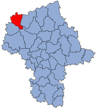
Garwolin County is a unit of territorial administration and local government (powiat) in Masovian Voivodeship, east-central Poland. It came into being on 1 January 1999, as a result of the Polish local government reforms passed in 1998. Its administrative seat and largest town is Garwolin, which lies 56 kilometres (35 mi) south-east of Warsaw. The county contains three other towns: Łaskarzew, 13 km (8 mi) south of Garwolin, Pilawa, 10 km (6 mi) north-west of Garwolin, and Żelechów, 22 km (14 mi) south-east of Garwolin.

Maków County is a unit of territorial administration and local government (powiat) in Masovian Voivodeship, east-central Poland. It came into being on January 1, 1999, as a result of the Polish local government reforms passed in 1998. Its administrative seat and largest town is Maków Mazowiecki, which lies 73 kilometres (45 mi) north of Warsaw. The only other town in the county is Różan, lying 20 km (12 mi) east of Maków Mazowiecki.
Węgrów County is a unit of territorial administration and local government (powiat) in Masovian Voivodeship, east-central Poland. It came into being on January 1, 1999, as a result of the Polish local government reforms passed in 1998. Its administrative seat and largest town is Węgrów, which lies 73 kilometres (45 mi) east of Warsaw. The only other town in the county is Łochów, lying 26 km (16 mi) north-west of Węgrów.

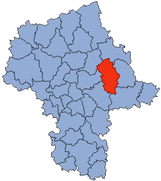
Otwock County is a unit of territorial administration and local government (powiat) in Masovian Voivodeship, east-central Poland. It came into being on January 1, 1999, as a result of the Polish local government reforms passed in 1998. Its administrative seat and largest town is Otwock, which lies 22 kilometres (14 mi) south-east of Warsaw. The county also contains the towns of Józefów, lying 3 km (2 mi) north-west of Otwock, and Karczew, 4 km (2 mi) south of Otwock.

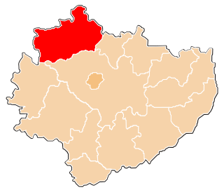
Przasnysz County is a unit of territorial administration and local government (powiat) in Masovian Voivodeship, east-central Poland. It came into being on 1 January 1999, as a result of the Polish local government reforms passed in 1998. Its administrative seat and largest town is Przasnysz, which lies 90 kilometres (56 mi) north of Warsaw. The only other town in the county is Chorzele, lying 26 km (16 mi) north of Przasnysz. The county covers an area of 1,217.82 square kilometres (470.2 sq mi). As of 2019, its total population is 52,616, out of which the population of Przasnysz is 17,264, that of Chorzele is 3,088, and the rural population is 32,324.
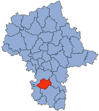
Białobrzegi County is a unit of territorial administration and local government (powiat) in Masovian Voivodeship, east-central Poland. It came into being on January 1, 1999, as a result of the Polish local government reforms passed in 1998. Its administrative seat and largest town is Białobrzegi, which lies 63 kilometres (39 mi) south of Warsaw. The only other town in the county is Wyśmierzyce, lying 10 km (6 mi) west of Białobrzegi.
Żuromin County is a unit of territorial administration and local government (powiat) in Masovian Voivodeship, east-central Poland. It came into being on January 1, 1999, as a result of the Polish local government reforms passed in 1998. Its administrative seat and largest town is Żuromin, which lies 121 kilometres (75 mi) north-west of Warsaw. Other towns in the county are Bieżuń, lying 13 km (8 mi) south of Żuromin and Lubowidz, lying 9 km (6 mi) north-west of Żuromin.

Płońsk County is a unit of territorial administration and local government (powiat) in Masovian Voivodeship, east-central Poland. It came into being on 1 January 1999, as a result of the Polish local government reforms passed in 1998. Its administrative seat and largest town is Płońsk, which lies 63 kilometres (39 mi) north-west of Warsaw. The only other town in the county is Raciąż, lying 25 km (16 mi) north-west of Płońsk.

Jędrzejów County is a unit of territorial administration and local government (powiat) in Świętokrzyskie Voivodeship, south-central Poland. It came into being on January 1, 1999, as a result of the Polish local government reforms passed in 1998. Its administrative seat and largest town is Jędrzejów, which lies 36 kilometres (22 mi) south-west of the regional capital Kielce. The county also contains the towns of Sędziszów, lying 18 km (11 mi) west of Jędrzejów, and Małogoszcz, 21 km (13 mi) north of Jędrzejów.

Opatów County is a unit of territorial administration and local government (powiat) in Świętokrzyskie Voivodeship, south-central Poland. It came into being on January 1, 1999, as a result of the Polish local government reforms passed in 1998. Its administrative seat and largest town is Opatów, which lies 58 kilometres (36 mi) east of the regional capital Kielce. The only other town in the county is Ożarów, lying 20 km (12 mi) north-east of Opatów.
Końskie County is a unit of territorial administration and local government (powiat) in Świętokrzyskie Voivodeship, central Poland. It came into being on January 1, 1999, as a result of the Polish local government reforms passed in 1998. Its administrative seat and largest town is Końskie, which lies 38 kilometres (24 mi) north of the regional capital Kielce. The only other town in the county is Stąporków, lying 11 km (7 mi) south-east of Końskie.

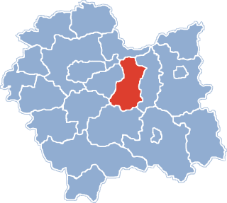
Proszowice County is a unit of territorial administration and local government (powiat) in Lesser Poland Voivodeship, southern Poland. It came into being on January 1, 1999, as a result of the Polish local government reforms passed in 1998. Its administrative seat is Proszowice, which lies 31 kilometres (19 mi) north-east of the regional capital Kraków. Its only other town is Nowe Brzesko.

Limanowa County is a unit of territorial administration and local government (powiat) in Lesser Poland Voivodeship, southern Poland. It came into being on January 1, 1999, as a result of the Polish local government reforms passed in 1998. Its administrative seat and largest town is Limanowa, which lies 54 kilometres (34 mi) south-east of the regional capital Kraków. The only other town in the county is Mszana Dolna, lying 27 km (17 mi) west of Limanowa.The county is divided between Gorals in the territories of gmina Mszana Dolna and gmina Niedziewiedź and Lachs in the rest of the territory.
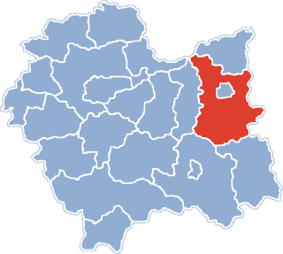
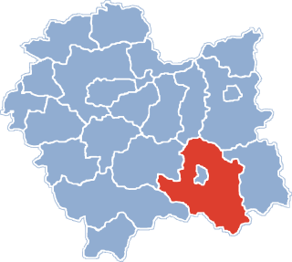
Tarnów County is a unit of territorial administration and local government (powiat) in Lesser Poland Voivodeship, southern Poland. It came into being on January 1, 1999, as a result of the Polish local government reforms passed in 1998. Its administrative seat is the city of Tarnów, although the city is not part of the county. The county contains seven towns: Tuchów, 16 km (10 mi) south of Tarnów, Żabno, 14 km (9 mi) north-west of Tarnów, Wojnicz, 15 km (9 mi) south-west of Tarnów, Radłów, 13 km (8 mi) north-west of Tarnów, Ryglice, 20 km (12 mi) south-east of Tarnów, Ciężkowice, 26 km (16 mi) south of Tarnów, and Zakliczyn, 25 km (16 mi) south-west of Tarnów.