Hunters Creek Village, Texas

Last updated

City of Hunters Creek Village
HuntersCreekVillageCityHall.JPG
Hunters Creek Village City Hall
Harris County Texas incorporated and unincorporated areas Hunters Creek Village highlighted.svg
Location in Harris County and the state of Texas
Coordinates: 29°46′11″N95°30′1″W / 29.76972°N 95.50028°W / 29.76972; -95.50028
Country United States
State Texas
County Harris
Incorporated1954
Government
  TypeCity Council
  MayorJim Pappas
Area
[1]
  Total1.95 sq mi (5.06 km2)
  Land1.95 sq mi (5.06 km2)
  Water0.00 sq mi (0.00 km2)
Elevation
66 ft (20 m)
Population
 (2020)
  Total4,385
  Density2,491.81/sq mi (962.25/km2)
Time zone UTC-6 (Central (CST))
  Summer (DST) UTC-5 (CDT)
ZIP code
77024
Area code 713
FIPS code 48-35480 [2]
GNIS feature ID1374180 [3]
Website cityofhunterscreek.com
City of Hunters Creek Village City Hall.jpg

Hunters Creek Village is a city in Harris County, Texas, United States, part of the Greater Houston metropolitan area. The population was 4,385 at the 2020 census. [4] It is part of a collection of upscale residential communities in west Houston known as the Memorial Villages.

Contents

As of 2022, Hunters Creek Village is the 403rd largest city in the State of Texas. As of 2000, Hunters Creek Village was the 5th wealthiest location in Texas by per capita income. A 2010 BusinessWeek study stated that Hunters Creek Village was the most expensive suburb in Texas. [5]

History

Prior to the incorporation of Hunters Creek Village, German farmers settled the area and opened sawmills. By 1936 the community had a sawmill and several residences. [6]

In the mid-1950s, effort to form a Spring Branch municipality failed. [7] The city incorporated in 1954 with a mayor-alderman government. [6] Because of the 1954 incorporation, Houston did not incorporate Hunters Creek Village's territory into its city limits, while Houston annexed surrounding areas that were unincorporated. [8] By 1966 year the community had a school and a church. Between 1960 and 1980 the population increased from 2,478 to 4,580. In 1982 the population fell to 4,215. 4,598 people lived in Hunters Creek Village in 1990. [6]

In 2008, Forbes.com selected Hunters Creek Village, along with the adjacent community of Bunker Hill Village and (southwest suburban) Sugar Land, as one of the three Houston-area "Top Suburbs To Live Well." [9]

Geography

Map of Hunters Creek Village HuntersCreekVillageMap.gif
Map of Hunters Creek Village

Hunters Creek Village is located at 29°46′11″N95°30′1″W / 29.76972°N 95.50028°W / 29.76972; -95.50028 (29.769632, –95.500190). [10]

According to the United States Census Bureau, the city has a total area of 1.9 square miles (4.9 km2), all of it land.

Demographics

Historical population
CensusPop.Note
1960 2,478
1970 3,95959.8%
1980 4,2156.5%
1990 3,954−6.2%
2000 4,37410.6%
2010 4,367−0.2%
2020 4,3850.4%
U.S. Decennial Census [11]
Hunters Creek Village racial composition as of 2020 [12]
(NH = Non-Hispanic) [lower-alpha 1]
RaceNumberPercentage
White (NH)3,50880.0%
Black or African American (NH)370.84%
Native American or Alaska Native (NH)70.16%
Asian (NH)3507.98%
Some Other Race (NH)180.41%
Mixed/Multi-Racial (NH)1292.94%
Hispanic or Latino 3367.66%
Total4,385

As of the 2020 United States census, there were 4,385 people, 1,657 households, and 1,466 families residing in the city.

As of the census [2] of 2000, there were 4,374 people, 1,471 households, and 1,291 families residing in the city. The population density was 2,253.0 inhabitants per square mile (869.9/km2). There were 1,523 housing units at an average density of 784.5 per square mile (302.9/km2). The racial makeup of the city was 93.37% White, 0.37% African American, 0.14% Native American, 4.80% Asian, 0.46% from other races, and 0.87% from two or more races. Hispanic or Latino of any race were 3.59% of the population.

A sign indicating Hunters Creek Village HuntersCreekVillageSign.JPG
A sign indicating Hunters Creek Village

There were 1,471 households, out of which 43.6% had children under the age of 18 living with them, 82.9% were married couples living together, 3.9% had a female householder with no husband present, and 12.2% were non-families. 11.1% of all households were made up of individuals, and 7.7% had someone living alone who was 65 years of age or older. The average household size was 2.97 and the average family size was 3.19.

In the city, the population was spread out, with 31.2% under the age of 18, 3.3% from 18 to 24, 19.6% from 25 to 44, 29.9% from 45 to 64, and 15.9% who were 65 years of age or older. The median age was 43 years. For every 100 females, there were 92.8 males. For every 100 females age 18 and over, there were 89.4 males.

The median income for a household in the city was $171,294, and the median income for a family was $184,574. Males had a median income of $100,000 versus $48,750 for females. The per capita income for the city was $88,821. About 0.6% of families and 1.2% of the population were below the poverty line, including none of those under age 18 and 1.2% of those age 65 or over.

Government and infrastructure

Hunters Creek Village is a general-law city, governed by a Mayor and a City Council of five Councilmembers, all of which serve for staggered two-year terms. The current mayor of Hunters Creek Village is Jim Pappas as of May 2017. The Mayor, with Council approval, appoints members of the city's Planning and Zoning Commission and Board of Adjustment.

Bunker Hill Village, Hunters Creek Village, and Piney Point Village jointly operate the Memorial Villages Police Department through the Board of Police Commissioners consisting of representatives of those three Memorial villages. The Village Fire Department, which serves all of the Memorial villages, is governed by a Board of Commissioners consisting of representatives of each of the six Memorial villages . Hedwig Village and the portions of Piney Point Village and Hunters Creek Village north of the Buffalo Bayou lie within and are served by the Memorial Villages Water Authority.

Harris County Precinct Three, headed by Tom Ramsey, serves Hunters Creek Village. [15]

Hunters Creek Village is located in District 133 of the Texas House of Representatives. As of 2022 Mano DeAyala represents the district. [16] Hunters Creek Village is within District 7 of the Texas Senate; as of 2022 Paul Bettencourt represents the district. [17]

Hunters Creek Village is in Texas's 7th congressional district and represented as of 2022 by Wesley Hunt. In 2008, the pro-Republican Party publication Human Events identified the zip code 77024 as the zip code that gave the eighth largest contribution to John McCain's 2008 U.S. Presidential Election campaign. The zip code, which includes the portion of Hunters Creek Village north of the Buffalo Bayou, gave $540,309 United States dollars by October 24, 2008. [18] [19] [20]

Harris Health System (formerly Harris County Hospital District) designated Northwest Health Center for ZIP code 77024 and Valbona Health Center (formerly People's Health Center) in Greater Sharpstown for 77063. The nearest public hospital is Ben Taub General Hospital in the Texas Medical Center. [21]

Education

Hunters Creek Elementary School HuntersCreekElementaryHuntersCreekVillageTexas.JPG
Hunters Creek Elementary School

Primary and secondary schools

Public schools

Hunters Creek Village is located within two school districts, the Spring Branch Independent School District and, solely as to residences to the south of the Buffalo Bayou, the Houston Independent School District. [22]

Spring Branch Independent School District

Most of Hunters Creek Village is north of the Buffalo Bayou; that portion is served by the Spring Branch Independent School District. [22]

All residents are assigned to Wildcat Way School in Houston for preschool. [23]

One school, Hunters Creek Elementary School, is within the city boundaries. Most residents are zoned to Hunters Creek; some are zoned to Memorial Drive Elementary School in Piney Point Village. [24] [25] In 1954 the current Hunters Creek school opened. The district opened a new school building in August 2021. [26]

Students in Hunters Creek and in Memorial Drive Elementary all are zoned to Spring Branch Middle School and Memorial High School, which are in Hedwig Village. [27] [28]

Houston Independent School District

The portion south of the Buffalo Bayou is served by the Houston Independent School District. [22] [29]

HISD students are zoned to Briargrove Elementary School, [30] Tanglewood Middle School (formerly Grady Middle School), [31] and Margaret Long Wisdom High School (formerly Robert E. Lee High School) [32] (students may attend Lamar High School or Westside High School instead [33] ). Residents of the Briargrove Elementary School attendance zone may apply for the Briarmeadow Charter School. [34] Mark White Elementary School are scheduled to open in August 2016. Residents of the Briargrove Elementary zone, along with those of the Pilgrim, Piney Point, and Emerson zones, will be allowed to apply to this school. [35]

When Westside opened in 2000, [36] residents of the Lee attendance boundary gained the option to attend Westside instead of Lee, with taxpayer subsidized transportation provided. [37]

Private schools

Trinity Classical School has its middle school in the Memorial Middle Campus in the Chinese Baptist Church in Hunters Creek Village [38] [39]

Colleges and universities

Both Spring Branch ISD and Houston ISD (and therefore the whole city of Hunters Creek Village) are served by the Houston Community College System. [40] The Northwest College operates the nearby Spring Branch Campus in Houston.

Public libraries

The city is served by the Spring Branch Memorial Branch of Harris County Public Library (the Spring Branch Memorial Branch is in Hedwig Village).

Media

The Houston Chronicle is the area regional newspaper.

The Memorial Examiner is a local newspaper distributed in the community .

Postal services

Most of Hunters Creek Village is within the 77024 ZIP code, while the section south of the Buffalo Bayou has the 77063 ZIP code.

The United States Postal Service location serving 77024 is the Memorial Park Post Office at 10505 Town and Country Way, Houston, Texas, 77024-9998.

The location serving 77063 is the John Dunlop Post Office at 8728 Beverlyhill Street, Houston, Texas, 77063-9998.

See also

Related Research Articles

<span class="mw-page-title-main">Bunker Hill Village, Texas</span> City in Texas, United States

Bunker Hill Village is a city in Harris County, Texas, United States, part of Houston–The Woodlands–Sugar Land metropolitan area. The population was 3,822 at the 2020 census. It is part of a collection of upscale residential communities in west Houston known as the Memorial Villages. As of 2010, Bunker Hill Village was the 6th wealthiest place in Texas. Also, Bunker Hill Village is one of Forbes top 25 places to retire rich.

<span class="mw-page-title-main">Hedwig Village, Texas</span> City in Texas, United States

Hedwig Village is a city in Harris County, Texas, United States. The population was 2,370 at the 2020 census.

<span class="mw-page-title-main">Hilshire Village, Texas</span> City in Texas, United States

Hilshire Village is a city in Harris County, Texas, United States. The population was 816 at the 2020 census. The city is the smallest of the Memorial Villages in terms of area.

<span class="mw-page-title-main">Nassau Bay, Texas</span> City in Texas, United States

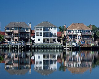
Nassau Bay is a city in Harris County, Texas, United States, bordering the outermost southeastern edge of the city of Houston. It is located in the Clear Lake Area near Galveston Bay, directly adjacent to the Lyndon B. Johnson Space Center. The population was 5,347 at the 2020 census.

<span class="mw-page-title-main">Piney Point Village, Texas</span> City in Texas, United States

Piney Point Village is a city in Harris County, Texas, United States. The population was 3,125 at the 2010 census. Piney Point Village is the wealthiest place in Texas, as ranked by per capita income. It is part of a collection of upscale residential communities in west Houston known as the Memorial Villages.

<span class="mw-page-title-main">Spring, Texas</span> Census-designated place in Texas, U.S.

Spring is a census-designated place (CDP) within the extraterritorial jurisdiction of Houston in Harris County, Texas, United States, part of the Houston–The Woodlands–Sugar Land metropolitan area. The population was 62,559 at the 2020 census. While the name "Spring" is popularly applied to a large area of northern Harris County and a smaller area of southern Montgomery County, the original town of Spring, now known as Old Town Spring, is located at the intersection of Spring-Cypress and Hardy roads and encompasses a relatively small area of perhaps 1 square kilometer (0.39 sq mi).

<span class="mw-page-title-main">Spring Valley Village, Texas</span> City in Texas, United States

Spring Valley Village is a city in Harris County, Texas, United States, and an enclave of Houston. The population was 4,229 at the 2020 U.S. census.

<span class="mw-page-title-main">Taylor Lake Village, Texas</span> City in Texas, United States

Taylor Lake Village is a city in Harris County in the U.S. state of Texas. The population was 3,704 at the 2020 U.S. census.

<span class="mw-page-title-main">Webster, Texas</span> City in Texas, United States

Webster is a city in the U.S. state of Texas located in Harris County, within the Houston–The Woodlands–Sugar Land metropolitan area. Its population was 12,499 at the 2020 U.S. census.

<span class="mw-page-title-main">Seabrook, Texas</span> City in Texas, United States

Seabrook is a city in Harris County in the U.S. state of Texas, with some water surface area located within Chambers County. The population was 11,952 at the 2010 U.S. census, and 14,149 in 2019. Several fish markets line the city's waterfront, while antique shops and bed and breakfast establishments are found in the city's downtown area. The city is home to several miles of trails, which connect multiple city parks to each other.

<span class="mw-page-title-main">Spring Branch, Houston</span> Neighborhood in Houston, Texas, US

Spring Branch is a district in west-northwest Harris County, Texas, United States, roughly bordered by Tanner Road and Hempstead Road to the north, Beltway 8 to the west, Interstate 10 to the south, and the 610 Loop to the east; it is almost entirely within the city of Houston. Established by the Texas Legislature, the Spring Branch Management District exercises jurisdiction over the area.

<span class="mw-page-title-main">Spring Branch Independent School District</span> School district near Houston, Texas, United States

Spring Branch Independent School District is a school district headquartered in Hedwig Village, Texas, United States in Greater Houston. The district serves portions of western Houston, including most of Spring Branch. It also serves several small municipalities known as the Memorial Villages in its jurisdiction, such as Hedwig Village and Spring Valley Village. A majority of the district lies within Houston city limits.

Harrisburg is a community that is now located within the city of Houston, Texas, United States.

<span class="mw-page-title-main">Memorial, Houston</span> Super neighborhood in Harris County, Texas, United States

The Memorial area of Houston, Texas is located west of Downtown, northwest of Uptown, and south of Spring Branch. The Memorial Super Neighborhood, as defined by the City of Houston, is bounded by Buffalo Bayou to the south, Barker Reservoir to the west, Westview to the north, and the Memorial Villages, a contiguous group of independent municipalities, to the east.

<span class="mw-page-title-main">Westside High School (Houston)</span> Suburban public secondary school in Houston, TX

Westside High School is a secondary school in Houston, Texas, United States. It serves grades 9 through 12 and is part of the Houston Independent School District.

<span class="mw-page-title-main">Afton Oaks, Houston</span>

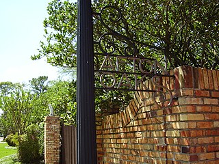
Afton Oaks is a deed-restricted "Inner Loop" upscale residential community of approximately 525 homes in Houston, Texas, United States. Afton Oaks is located inside Interstate 610 near the Galleria and Highland Village. The neighborhood is bounded on the north by Westheimer Road, on the east by Union Pacific railroad tracks, on the south by Interstate 69/U.S. Highway 59, and on the west by Interstate 610.

<span class="mw-page-title-main">Briargrove, Houston</span>

Briargrove is a neighborhood in Houston, Texas, United States, near Uptown Houston.

<span class="mw-page-title-main">Tanglewood, Houston</span>

Tanglewood is an affluent neighborhood in western Houston, Texas, located off San Felipe Road.
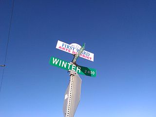
Crestwood/Glen Cove is a community in Houston, Texas. It consists of the Crestwood and Glen Cove subdivisions. The Crestwood/Glen Cove Civic Club serves the Crestwood/Glen Cove community.

Stablewood is a 72-acre (29 ha) community in Houston, just outside the 610 Loop. It is in proximity to the Houstonian Hotel, Club, and Spa.

References

  1. "2019 U.S. Gazetteer Files". United States Census Bureau. Retrieved August 7, 2020.
  2. 1 2 "U.S. Census website". United States Census Bureau . Retrieved January 31, 2008.
  3. "US Board on Geographic Names". United States Geological Survey. October 25, 2007. Retrieved January 31, 2008.
  4. "Profile of General Population and Housing Characteristics: 2010 Demographic Profile Data (DP-1): Hunters Creek Village city, Texas". United States Census Bureau . Retrieved June 15, 2012.
  5. Sarnoff, Nancy. "The state's most expensive suburb..." Houston Chronicle . November 22, 2010. Retrieved on December 7, 2010.
  6. 1 2 3 Hunter's Creek Village, Texas from the Handbook of Texas Online
  7. Spring Branch, Texas from the Handbook of Texas Online
  8. Lee, Renée C. "Annexed Kingwood split on effects." Houston Chronicle . Sunday October 8, 2006. A21. Retrieved on July 6, 2011. "Some of the area communities that incorporated as cities and escaped annexation by Houston:" Print version exclusively has the information cited; the information is not included in the online edition.
  9. Woolsey, Matt. "In Depth: Top Suburbs To Live Well". Forbes.
  10. "US Gazetteer files: 2010, 2000, and 1990". United States Census Bureau. February 12, 2011. Retrieved April 23, 2011.
  11. "Census of Population and Housing". Census.gov. Retrieved June 4, 2015.
  12. "Explore Census Data". data.census.gov. Retrieved May 23, 2022.
  13. https://www.census.gov/ [ not specific enough to verify ]
  14. "About the Hispanic Population and its Origin". www.census.gov. Retrieved May 18, 2022.
  15. "Precinct Maps : Precinct 3 Archived February 16, 2012, at the Wayback Machine ." Harris County. Accessed October 13, 2008.
  16. "House District 134 Archived June 2, 2008, at the Wayback Machine ." Texas House of Representatives. Accessed October 11, 2008.
  17. "Senate District 7 [ permanent dead link ]" Map. Senate of Texas . Accessed September 28, 2008.
  18. Connelly, Richard. "Memorial & Hunters Creek Village -- The Real America." Houston Press . October 24, 2008.
  19. "SW large.gif Archived February 27, 2009, at the Wayback Machine ." Zipfocus.com. Accessed October 28, 2008.
  20. "Texas's 7th Congressional District - TX-07 Representatives & District Map".
  21. "Clinic/Emergency/Registration Center Directory By ZIP Code". Harris County Hospital District. November 19, 2001. Archived from the original on November 19, 2001. Retrieved April 8, 2021. - See ZIP codes 77024 and 77063. See this map for relevant ZIP code.
  22. 1 2 3 "Zoning Map." City of Hunters Creek Village. Retrieved on December 6, 2018. Compare to: "2020 CENSUS - SCHOOL DISTRICT REFERENCE MAP: Harris County, TX" (PDF). U.S. Census Bureau. p. 4 (PDF p. 5/6). Retrieved June 9, 2023.
  23. "Early Childhood Archived June 5, 2006, at the Wayback Machine ." Spring Branch Independent School District .
  24. Hunters Creek Attendance Zone. Spring Branch Independent School District. Retrieved on December 6, 2018.
  25. Memorial Drive Attendance Zone. Spring Branch Independent School District. Retrieved on December 6, 2018.
  26. Kent, Roy (October 30, 2019). "Spring Branch ISD begins rebuilding schools". Houston Chronicle . Retrieved November 19, 2019.
  27. Spring Branch Middle Attendance Zone. Spring Branch Independent School District. Retrieved on December 6, 2018.
  28. Memorial High School Zone. Spring Branch Independent School District. Retrieved on December 6, 2018.
  29. "Trustee Districts Map Archived July 11, 2012, at the Wayback Machine ." Houston Independent School District . Retrieved on November 11, 2008.
  30. "Briargrove Elementary Attendance Zone."Houston Independent School District.
  31. "Tanglewood Attendance Zone."Houston Independent School District.
  32. "Wisdom High School Attendance Zone."Houston Independent School District.
  33. Home Page as of May 9, 2005. Lee High School.
  34. "Registration Archived May 7, 2008, at the Wayback Machine ." Briarmeadow Charter School. Retrieved on May 7, 2009.
  35. Baird, Annette. "Planned HISD elementary to relieve crowding." Houston Chronicle . June 10, 2014. Retrieved on December 21, 2014.
  36. "Personal Touches." Education Week .
  37. "Westside and Lee HS Boundaries." Houston Independent School District . October 3, 2000. Retrieved on May 7, 2009.
  38. "Contact Information". Trinity Classical School . Retrieved June 27, 2022.
  39. "HuntersCreek_WallMap_2014Update.pdf" (PDF). Hunters Creek Village. Retrieved June 27, 2022. - Chinese Church's location is indicated
  40. Sec. 130.182. HOUSTON COMMUNITY COLLEGE SYSTEM DISTRICT SERVICE AREA.
  1. Note: the US Census treats Hispanic/Latino as an ethnic category. This table excludes Latinos from the racial categories and assigns them to a separate category. Hispanics/Latinos can be of any race. [13] [14]