Remington Ranch, Texas

Last updated

Remington Ranch is a master planned community located in unincorporated Harris County, Texas, United States. The development, with 2,100 single-family houses, is located between Interstate 45 and the Hardy Toll Road. It is north of Greenspoint Mall and in proximity to George Bush Intercontinental Airport. [1]

Contents

History and development

In 2003 Dickson Partners, a Houston developer, purchased a 510-acre (210 ha) plot of land from Houston investors. [1] The majority of the purchased land belonged to three families from Houston who, since the 1950s, had owned the land. [2] Dickson intended to develop a new community on that site. [1]

As of 2003, the houses were expected to be priced below $200,000. [1] The price range of the houses was planned to be from the $80,000s to the $180,000s. [2] KB Home, one developer, bought 143 acres (58 ha) from Dickson and planned to develop 900 houses priced from $80,000 to $130,000. [1] The remaining single family acreage was to be developed by Newmark Homes and Parkside Homes into 1,200 houses. Two separate parcels of land, with a total of 51 acres (21 ha) of land, were to be used for commercial and other non-single family uses. [2] Edminster Hinshaw Russ & Associates provided Remington Ranch's land planning and engineering. [1] Mark Powell, vice president of Dickson Partners, said that the access to George Bush Intercontinental Airport, Greenspoint Mall, the Hardy Toll Road, and Interstate 45 motivated the company to develop the Remington Ranch property. In 2003, the company was negotiating with the school district with regard to the possibility of selling land for the development of a future elementary or middle school. Powell also cited the location in the Spring Independent School District as a factor in purchasing the land. [2]

House construction was scheduled to begin in June 2004. [2] Housing sales began in April 2004. The $65 million Remington Ranch development was scheduled to be sold out by 2008. [3] By 2006, the homes offered were priced from the $80,000s to the $150,000s. [4] By 2008 K. Hovanian Homes became a house builder in Remington Ranch. [5] By 2009 Remington Ranch had a high foreclosure rate. [6]

Parks and recreation

The development was scheduled to include a recreation center with an Olympic-sized swimming pool and a playground area. The plans also included the establishment of neighborhood parks. [2] The development also has a splash park and a barbecue area. [4]

Education

Remington Ranch is zoned to the Spring Independent School District. [7]

Most residents are zoned to Milton Cooper Elementary School, while some are zoned to R.J. Hoyland Elementary School. [8] All residents are zoned to Bammel Middle School and Dekaney High School. [9] [10] In February 2017 the district proposed redrawing the attendance boundaries of its middle schools. [11] According to the proposed 2017-2018 middle school map, Remington Ranch will be reassigned from Bammel Middle School to Dueitt Middle School in the Spring census-designated place. [12] [13]

When Remington Ranch first opened, it was zoned to Clark Primary and Elementary School and Westfield High School. [14] Cooper opened in 2005. [15] The community was rezoned to Dekaney after Dekaney's opening in August 2007. [16] Hoyland was completed in the summer of 2009. [17]

Students have the option to attend Carl Wunsche Sr. High School, a career academy in the district, instead of their home school.

Areas in Spring ISD (and therefore Remington Ranch) are located in Lone Star College. [18]

Related Research Articles

<span class="mw-page-title-main">Chinatown, Houston</span> Neighborhood of Houston in Harris County, Texas, United States

Chinatown is a community in Southwest Houston, Texas, United States.

<span class="mw-page-title-main">Sharpstown, Houston</span> Community in Houston, Texas

Sharpstown is a master-planned community in the Southwest Management District, Southwest Houston, Texas. It was one of the first communities to be built as a master-planned, automobile centered community and the first in Houston. Frank Sharp (1906–1993), the developer of the subdivision, made provisions not only for homes but also for schools, shopping and recreation areas. While this model has been duplicated countless times in the past fifty years, at the time it was quite revolutionary, attracting national media attention. The development was dedicated on March 13, 1955.

<span class="mw-page-title-main">Rice Military, Houston</span>

Rice Military is a neighborhood in Houston, Texas, United States. The Beer Can House is located in Rice Military.

<span class="mw-page-title-main">Shadow Creek Ranch</span> Planned community in Pearland, Texas, US

Shadow Creek Ranch is a planned community in Pearland, Texas, United States. Shadow Creek Ranch, which has 3,500 acres (1,400 ha) of space, is west of State Highway 288, south of Beltway 8, and about 10 miles (16 km) from the Texas Medical Center.

Spring Independent School District is a school district based in the Gordon M. Anderson Leadership Center in unincorporated Harris County, Texas, United States. It is located in north Harris County.

<span class="mw-page-title-main">Westfield High School (Harris County, Texas)</span> Public school in Houston, Texas, United States

Westfield High School is a high school located in unincorporated Harris County, Texas, United States, near Houston.

<span class="mw-page-title-main">University Oaks, Houston</span>

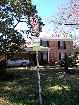
University Oaks is a subdivision in southeast Houston with approximately 240 homes located adjacent to the University of Houston. It is bounded by Wheeler Avenue to the north, South MacGregor Way to the south, Calhoun Road to the east, and Cullen Boulevard to the west.

<span class="mw-page-title-main">Spring High School</span> Public school in Spring, Texas, United States

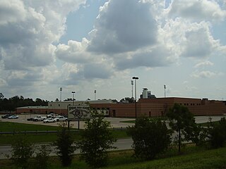
Spring High School is a public high school located in the Spring census-designated place in unincorporated Harris County, Texas, United States.

<span class="mw-page-title-main">Greenspoint, Houston</span> Neighborhood and business district in Harris County, Texas, United States

Greater Greenspoint, also referred to as the North Houston District, is a 7-square-mile (18 km2) business district and a suburban neighborhood in northern Harris County, Texas, United States, located mostly within the city limits of Houston. Centered around the junction of Interstate 45 and Texas State Highway Beltway 8 near George Bush Intercontinental Airport, the area is a classic example of a planned edge city. The initial 2,000-acre (8.1 km2) retail and office development centered around Greenspoint Mall was a project of the Friendswood Development Company during the 1970s and early 1980s.

<span class="mw-page-title-main">Glenbrook Valley, Houston</span>

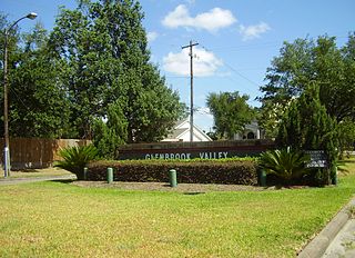
Glenbrook Valley is a subdivision located in Houston, Texas, United States.

<span class="mw-page-title-main">Dekaney High School</span> Public school in Harris County, Texas, United States

Andy Dekaney High School is a public secondary school located at 22351 Imperial Valley Drive and Bammel Road in unincorporated Harris County, Texas, United States, with a ZIP code of 77073.

Kleinbrook is an unincorporated community in northwestern Harris County, Texas, United States.

<span class="mw-page-title-main">City Park, Houston</span> Development in Houston, Texas, US

City Park is a development in Houston, Texas, United States, that encompasses the subdivisions of City Park, City Park West, and City Oaks. It is within the Five Corners District and has 475 acres (192 ha) of space.

<span class="mw-page-title-main">Brays Oaks, Houston</span>

Brays Oaks, formerly known as Fondren Southwest, is an area in Southwest Houston, Texas, United States. The Brays Oaks Management District, also known as the Harris County Improvement District #5, governs the Brays Oaks area as well as other surrounding areas, such as Westbury. The City of Houston also defines the Brays Oaks Super Neighborhood, with separate boundaries.

<span class="mw-page-title-main">Montrose District, Houston</span>

The Montrose District was a management district located in Houston, Texas, United States. The land was governed by the Montrose Management District.

Ponderosa Forest is a residential neighborhood in unincorporated northwestern Harris County, Texas, United States. It is located near Farm to Market Road 1960, also referred to as Cypress Creek Parkway.

Windsor Village is a community in Houston, in the U.S. state of Texas. The Windsor Village United Methodist Church is located in the community. The name of the community reflected a British motif popular in the late 1950s and early 1960s.

<span class="mw-page-title-main">Shadyside, Houston</span>

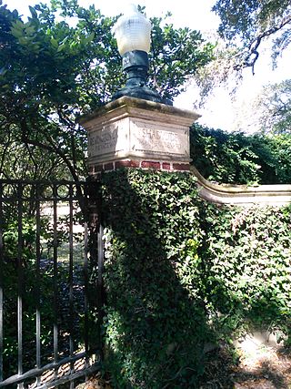
Shadyside is a private, walled subdivision of 16 houses in Houston, Texas. In 2012 Terrence McCoy of the Houston Press said that Shadyside has a "sense of exclusivity, or as Heritage Texas Properties puts it, 'mystique,'" which caused many prominent figures from Houston to settle in Shadyside and continue doing so for a period of almost 100 years.

Cottage Grove is a community in Houston, Texas.

<span class="mw-page-title-main">Lakes of Parkway, Houston</span> Housing subdivision

Lakes of Parkway is a gated community in western Houston, Texas, also the most southern community in the Energy Corridor. It has 888 lots. Peggy O'Hare of the Houston Chronicle stated in 2002 that the houses were "upscale".

References

  1. 1 2 3 4 5 6 Bivins, Ralph. "Developer lassos site for homes near airport." Houston Chronicle . Sunday August 10, 2003. Business 6. Retrieved on March 25, 2010.
  2. 1 2 3 4 5 6 Sarnoff, Nancy. "Huge residential community taking shape in Greenspoint." Houston Business Journal . Friday August 1, 2003. Retrieved on March 25, 2010.
  3. Wollam, Allison. "KB Home gets rolling on set of new residential communities." Houston Business Journal . Friday September 17, 2004. Retrieved on March 25, 2010.
  4. 1 2 Wilder, Burt. "'Upscale affordable housing' fills niche for buyers on a budget." Houston Business Journal . Friday April 14, 2006. Retrieved on March 25, 2010.
  5. Barr, Greg. "Home builders' problems could reverberate in Houston market." Houston Business Journal . Friday February 1, 2008. Retrieved on March 25, 2010.
  6. Sarnoff, Nancy. "Last year proved tough for area home sales." Houston Chronicle . January 20, 2009. Retrieved on March 25, 2010.
  7. "2008-2009 Zone Map." Spring Independent School District. Retrieved on March 25, 2010.
  8. "Elementary School Attendance Zones Archived 2010-12-21 at the Wayback Machine ." Spring Independent School District. Retrieved on March 25, 2010.
  9. "Middle School Attendance Zones Archived 2010-12-21 at the Wayback Machine ." Spring Independent School District. Retrieved on March 25, 2010.
  10. "High School Attendance Zones Archived 2011-03-04 at the Wayback Machine ." Spring Independent School District. Retrieved on March 25, 2010.
  11. Hill, Glynn A. (February 22, 2017). "Spring ISD considers attendance zone changes". The Spring Observer at the Houston Chronicle . Retrieved April 18, 2017.
  12. "Middle School Attendance Zone 2017-2018." Spring Independent School District. Retrieved on April 18, 2017.
  13. "Current Middle School Boundary." Spring Independent School District. Retrieved on April 18, 2017.
  14. "Student Attendance Zone Map 2004-2005." Spring Independent School District. August 21, 2004. Retrieved on March 25, 2010.
  15. "05-06 Attendance Boundaries." Spring Independent School District. September 30, 2007. Retrieved on March 25, 2010.
  16. "06-07 Attendance Zones." Spring Independent School District. September 30, 2007. Retrieved on March 25, 2010.
  17. "R. J. Hoyland Elementary School." Spring Independent School District. Retrieved on March 25, 2010.
  18. Sec. 130.191. LONE STAR COLLEGE SYSTEM DISTRICT SERVICE AREA.