Auburn, Pennsylvania

Last updated
Auburn, Pennsylvania
Borough
Auburn, Pennsylvania (6293676488).jpg
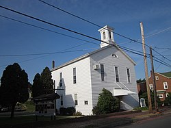
A church in Auburn, Pennsylvania in October 2011
Schuylkill County Pennsylvania Incorporated and Unincorporated areas Auburn Highlighted.svg
Location of Auburn in Schuylkill County, Pennsylvania
USA Pennsylvania location map.svg
Red pog.svg
Auburn
Location in Pennsylvania
Usa edcp location map.svg
Red pog.svg
Auburn
Auburn (the United States)
Coordinates: 40°35′45″N76°05′34″W / 40.59583°N 76.09278°W / 40.59583; -76.09278
Country United States
State Pennsylvania
County Schuylkill
Incorporated1857
Government
  TypeBorough Council
Area
[1]
  Total1.67 sq mi (4.34 km2)
  Land1.62 sq mi (4.20 km2)
  Water0.05 sq mi (0.13 km2)
Elevation
479 ft (146 m)
Population
 (2020) [2]
  Total660
  Density406.65/sq mi (156.97/km2)
Time zone UTC-5 (Eastern (EST))
  Summer (DST) UTC-4 (EDT)
ZIP Code
17922
Area codes 570 and 272
FIPS code 42-03488

Auburn is a borough in Schuylkill County, Pennsylvania, United States. The population was 663 at the 2020 census. [3]

Contents

History

The area was historically known as the "Scotchman's Lock". The first house in what is today Auburn was built in the late 1830s by a boatman named Samuel Moyer, who also operated a store there. In 1842, the Philadelphia and Reading Railroad reached the area, at which point the area's official name was changed to "Auburn". The Susquehanna and Schuylkill Railroad reached Auburn in 1857. The first post office in Auburn was built in 1846 and the first school was set up in 1845. [4]

Geography

Auburn is located at 40°35′45″N76°5′34″W / 40.59583°N 76.09278°W / 40.59583; -76.09278 (40.595715, -76.092642). [5] According to the United States Census Bureau, the borough has a total area of 1.7 square miles (4.4 km2), of which 1.7 square miles (4.4 km2) is land and 0.60% is water.

The borough's terrain is steeply hilly in the north and gently hilly in the south. Auburn's land is mostly forest, with some residential and agricultural areas. The Schuylkill River runs through Auburn. The borough is served by Pennsylvania Route 895. [6]

Demographics

Historical population
CensusPop.Note
1860 527
1870 511−3.0%
1880 74044.8%
1890 88018.9%
1900 845−4.0%
1910 9219.0%
1920 9776.1%
1930 1,17019.8%
1940 978−16.4%
1950 9941.6%
1960 936−5.8%
1970 895−4.4%
1980 99911.6%
1990 913−8.6%
2000 839−8.1%
2010 741−11.7%
2020 663−10.5%
2021 (est.)663 [3] 0.0%
Sources: [7] [8] [9] [2]

As of the census [10] of 2000, there were 839 people, 325 households, and 242 families residing in the borough. The population density was 505.4 inhabitants per square mile (195.1/km2). There were 340 housing units at an average density of 204.8 per square mile (79.1/km2). The racial makeup of the borough was 98.93% White, 0.83% African American, 0.12% Asian, and 0.12% from two or more races.

There were 325 households, out of which 33.5% had children under the age of 18 living with them, 57.2% were married couples living together, 11.7% had a female householder with no husband present, and 25.5% were non-families. 22.5% of all households were made up of individuals, and 10.8% had someone living alone who was 65 years of age or older. The average household size was 2.58 and the average family size was 3.02.

In the borough the population was spread out, with 24.7% under the age of 18, 6.8% from 18 to 24, 32.1% from 25 to 44, 23.7% from 45 to 64, and 12.8% who were 65 years of age or older. The median age was 38 years. For every 100 females, there were 100.2 males. For every 100 females age 18 and over, there were 92.1 males.

The median income for a household in the borough was $36,905, and the median income for a family was $40,833. Males had a median income of $33,021 versus $20,707 for females. The per capita income for the borough was $15,705. About 8.3% of families and 7.7% of the population were below the poverty line, including 12.4% of those under age 18 and 1.8% of those age 65 or over.

Related Research Articles

<span class="mw-page-title-main">Centerport, Pennsylvania</span> Borough in Pennsylvania, United States

Centerport is a borough in north central Berks County, Pennsylvania, United States. The population was 314 at the 2020 census. The borough is in the Schuylkill Valley School District.

<span class="mw-page-title-main">Conyngham Township, Columbia County, Pennsylvania</span> Township in Pennsylvania, United States

Conyngham Township is a township in Columbia County, Pennsylvania, United States. It is part of Northeastern Pennsylvania. The population was 689 at the 2020 census. Conyngham Township surrounds the famous borough of Centralia, and part of the mine fire is located here. The abandoned town of Byrnesville is located here.

Locustdale is a census-designated place (CDP) that is located on the border of Columbia and Schuylkill counties, Pennsylvania, United States. It is part of Northeastern Pennsylvania.

<span class="mw-page-title-main">Conshohocken, Pennsylvania</span> Borough in Pennsylvania, United States

Conshohocken is a borough on the Schuylkill River in Montgomery County, Pennsylvania in suburban Philadelphia. Historically a large mill town and industrial and manufacturing center, after the decline of industry in recent years Conshohocken has developed into a center of riverfront commercial and residential development. In the regional slang, it is sometimes referred to by the colloquial nickname Conshy.

<span class="mw-page-title-main">West Conshohocken, Pennsylvania</span> Borough in Pennsylvania, United States

West Conshohocken is a borough in Montgomery County, Pennsylvania, United States. The population was 1,320 at the 2010 census.

<span class="mw-page-title-main">Cressona, Pennsylvania</span> Borough in Pennsylvania, United States

Cressona is a borough in Schuylkill County, Pennsylvania. Formed in 1857 from part of North Manheim Township, it was founded by and named for John Chapman Cresson, a Philadelphia civil engineer and manager of the Schuylkill Navigation Company, president of the Mine Hill and Schuylkill Haven Railroad, and the chief engineer of Fairmount Park in Philadelphia.

<span class="mw-page-title-main">Deer Lake, Pennsylvania</span> Borough in Pennsylvania, United States

Deer Lake is a borough in Schuylkill County, Pennsylvania. The population was 670 at the 2020 census. The mayor of the borough is Larry Kozlowski.

<span class="mw-page-title-main">Frackville, Pennsylvania</span> City in Pennsylvania, United States

Frackville is a borough in Schuylkill County, Pennsylvania. Incorporated in 1876, Frackville is located at the intersection of Interstate 81 and Pennsylvania State Route 61, which is approximately 102 miles (164 km) northwest of Philadelphia and 60 miles (97 km) southwest of Scranton. Frackville is named for Daniel Frack, an early Anglo-American settler.

<span class="mw-page-title-main">Gilberton, Pennsylvania</span> Borough in Pennsylvania, United States

Gilberton is a borough in Schuylkill County, Pennsylvania, United States, four miles (7 km) west by south of Mahanoy City. Its population was 583 at the 2020 census, a decline from the figure of 769 tabulated in 2010. Extensive deposits of anthracite coal are in the region, and coal-mining had been practiced by many of the 4,373 people who lived there in 1900. The coal-mining industry was thriving in 1910, and 5,401 people lived in Gilberton.

<span class="mw-page-title-main">Gordon, Pennsylvania</span> Borough in Pennsylvania, United States

Gordon is a borough in Schuylkill County, Pennsylvania, United States. The population was 765 at the 2020 census.

<span class="mw-page-title-main">Lake Wynonah, Pennsylvania</span> CDP in Pennsylvania, United States

Lake Wynonah is a census-designated place (CDP) in Schuylkill County, Pennsylvania, United States. The population was 1,961 at the 2000 census, and 2,640 at the 2010 census. Lake Wynonah is a gated community with two lakes, Fawn Lake and Lake Wynonah, and as of July 2008, there are over 1200 homes and 1500 members. It is in South Manheim and Wayne Townships.

<span class="mw-page-title-main">Landingville, Pennsylvania</span> Borough in Pennsylvania, United States

Landingville is a borough in Schuylkill County, Pennsylvania, United States. The population was 137 at the time of the 2020 census.

<span class="mw-page-title-main">Mechanicsville, Schuylkill County, Pennsylvania</span> Borough in Pennsylvania, United States

Mechanicsville is a borough in Schuylkill County, Pennsylvania, United States. Part of the Pottsville Area School District, it lies between Pottsville and Port Carbon. Pottsville Street is the community's main street.

<span class="mw-page-title-main">Middleport, Pennsylvania</span> Borough in Pennsylvania, United States

Middleport is a borough in Schuylkill County, Pennsylvania, United States. The population was 363 at the time of the 2020 census.

<span class="mw-page-title-main">New Ringgold, Pennsylvania</span> Borough in Pennsylvania, United States

New Ringgold is a borough in Schuylkill County, Pennsylvania, United States. The population was 253 at the time of the 2020 census.

<span class="mw-page-title-main">Orwigsburg, Pennsylvania</span> Borough in Pennsylvania, United States

Orwigsburg is a borough in Schuylkill County, Pennsylvania. The borough was named for its founder, Peter Orwig, and created from West Brunswick Township in 1823.

<span class="mw-page-title-main">Port Carbon, Pennsylvania</span> Borough in Pennsylvania, United States

Port Carbon is a borough of Schuylkill County, Pennsylvania, United States, located two miles (3 km) northeast of Pottsville. It is in a coal-mining area. In the past, ironworks had been a feature of the borough. In 1900, 2,168 people lived here and, in 1910, 2,678. The population was 1,815 at the 2020 census.

<span class="mw-page-title-main">Port Clinton, Pennsylvania</span> Borough in Pennsylvania, United States

Port Clinton is a borough in Schuylkill County, Pennsylvania. It is located at the confluence of the Schuylkill and Little Schuylkill rivers, it was a port on the Schuylkill Canal and named after DeWitt Clinton.

<span class="mw-page-title-main">Ringtown, Pennsylvania</span> Borough in Pennsylvania, United States

Ringtown is a borough that is located in Schuylkill County, Pennsylvania, United States. It is approximately five miles north to northwest of Shenandoah and seventeen miles west to southwest of Hazleton.

<span class="mw-page-title-main">Tremont, Pennsylvania</span> Borough in Pennsylvania, United States

Tremont is a borough in Schuylkill County, Pennsylvania, United States. Situated in the eastern section of Tremont Township, it was incorporated as a borough in 1866, around the same time that a water system was erected in the community.

References

  1. "ArcGIS REST Services Directory". United States Census Bureau. Retrieved October 12, 2022.
  2. 1 2 "Census Population API". United States Census Bureau. Retrieved Oct 12, 2022.
  3. 1 2 "City and Town Population Totals: 2020—2021". Census.gov. US Census Bureau. Retrieved August 1, 2022.
  4. "Auburn Borough, Schuylkill County, Pennsylvania (PA)".
  5. "US Gazetteer files: 2010, 2000, and 1990". United States Census Bureau. 2011-02-12. Retrieved 2011-04-23.
  6. "Google Maps".
  7. "Census of Population and Housing: Decennial Censuses". United States Census Bureau . Retrieved 2012-03-04.
  8. "Incorporated Places and Minor Civil Divisions Datasets: Subcounty Resident Population Estimates: April 1, 2010 to July 1, 2012". Population Estimates. U.S. Census Bureau. Archived from the original on June 11, 2013. Retrieved 11 December 2013.
  9. "Census of Population and Housing". Census.gov. Retrieved June 4, 2016.
  10. "U.S. Census website". United States Census Bureau . Retrieved 2008-01-31.