Pine Grove, Schuylkill County, Pennsylvania

Last updated
Pine Grove, Pennsylvania
Borough
Pine Grove, Pennsylvania.jpg
Pine Grove Theatre, which opened in Pine Grove in 1910 and closed in 2019
Schuylkill County Pennsylvania Incorporated and Unincorporated areas Pine Grove Highlighted.svg
Location of Pine Grove in Schuylkill County, Pennsylvania
USA Pennsylvania location map.svg
Red pog.svg
Pine Grove
Location of Pine Grove in Pennsylvania
Usa edcp location map.svg
Red pog.svg
Pine Grove
Pine Grove (the United States)
Coordinates: 40°33′04″N76°23′06″W / 40.55111°N 76.38500°W / 40.55111; -76.38500
Country United States
State Pennsylvania
County Schuylkill
Settled1830
Incorporated1832
Government
  TypeBorough Council
  MayorRowan Medcraft
Area
[1]
  Total1.06 sq mi (2.76 km2)
  Land1.06 sq mi (2.76 km2)
  Water0.00 sq mi (0.00 km2)
Population
 (2020) [2]
  Total2,049
  Density1,923.94/sq mi (743.10/km2)
Time zone UTC-5 (Eastern (EST))
  Summer (DST) UTC-4 (EDT)
ZIP code
17963
Area code 570
FIPS code 42-60456
GNIS feature ID1215563

Pine Grove is a borough in Schuylkill County, Pennsylvania, United States. As of the 2020 census, the borough population was 2,054. [3]

Contents

Pine Grove Area School District, serving students from three municipalities and multiple surrounding townships, is located in the borough.

History

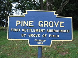
Pine Grove was officially incorporated in 1832. [4]

European settlement of the area by German Palatines, however, pre-dates this official founding date by at least several decades. Historical records document the Jacob Gunkle building was Lutheran church in the area as early as 1782. [5]

The historic Nutting Hall was built between 1823 and 1825. [6] Both Nutting Hall and the surrounding Pine Grove Historic District are listed on the National Register of Historic Places. [7]

The 335-seat Pine Grove Theatre, which is also part of the Pine Grove Historic District, opened in 1910 and is still up and running {2021}. [8]

Geography

Swatara Creek, a tributary of the Susquehanna River, runs through Pine Grove. [4] [9]

A 22-mile (35 km) feeder branch of the Union Canal connected the Swatara Creek at Pine Grove to Union Water Works between 1830 (or 1832) and 1862, until its destruction when the Swatara flooded in June 1862. The branch canal was used to ship anthracite [8] and supply water to the Water Works. Parts of Swatara State Park are located along the Swatara Creek within Pine Grove.

Demographics

Historical population
CensusPop.Note
1850 646
1870 845
1880 95713.3%
1890 1,10315.3%
1900 1,084−1.7%
1910 1,35224.7%
1920 1,77831.5%
1930 2,25726.9%
1940 2,239−0.8%
1950 2,237−0.1%
1960 2,2671.3%
1970 2,197−3.1%
1980 2,2442.1%
1990 2,118−5.6%
2000 2,1541.7%
2010 2,1861.5%
2020 2,054−6.0%
2021 (est.)2,057 [3] 0.1%
Sources: [10] [11] [12]

At the 2000 census, there were 2,154 people,877 households, and 558 families residing in the borough. The population density was 1,997.0 inhabitants per square mile (771.0/km2). There were 937 housing units at an average density of 868.7 per square mile (335.4/km2). The racial makeup of the borough was 98.75% White, 0.14% African American, 0.00% Native American, 0.51% Asian, 0.00% Pacific Islander, 0.09% from other races, and 0.51% from two or more races. 0.05% of the population were Hispanic or Latino of any race.

Of the 877 households, 27.6% had children under the age of 18 living with them, 50.4% were married couples living together, 9.7% had a female householder with no husband present, and 36.3% were non-families. 30.9% of households were one person, and 17.7% were one person aged 65 or older. The average household size was 2.36 and the average family size was 2.98.

In Pine Grove, the population was spread out, with 21.9% under the age of 18, 7.9% from 18 to 24, 28.6% from 25 to 44, 22.6% from 45 to 64, and 19.1% 65 or older. The median age was 39 years. For every 100 females there were 89.3 males. For every 100 females age 18 and over, there were 87.4 males.

The median household income was $35,865 and the median family income was $49,737. Males had a median income of $31,369 versus $21,818 for females. The per capita income for the borough was $19,547. 5.9% of the population and 2.6% of families were below the poverty line. Out of the total people living in poverty, 2.9% are under the age of 18 and 5.6% are 65 or older.

Notable people

Related Research Articles

<span class="mw-page-title-main">Bernville, Pennsylvania</span> Borough in Pennsylvania, United States

Bernville is a borough in Berks County, Pennsylvania, United States. The population was 905 at the 2020 census. Bernville is bordered by Penn Township to the north, east, and south and by Jefferson Township to the west. It is believed by few that the borough would have been a county seat of a small county called Tulpehocken County. However, no official sources can be found.

<span class="mw-page-title-main">Bethel Township, Berks County, Pennsylvania</span> Township in Pennsylvania, United States

Bethel Township is a township in Berks County, Pennsylvania, United States. The population was 4,072 at the 2020 census.

<span class="mw-page-title-main">Hamburg, Pennsylvania</span> Borough in Pennsylvania, United States

Hamburg is a borough in Berks County, Pennsylvania, United States. The population was 4,270 at the 2020 census. The town is thought to have been named after Hamburg, Germany, but this is likely to have been a corruption of Bad Homburg.

<span class="mw-page-title-main">Leesport, Pennsylvania</span> Borough in Pennsylvania, United States

Leesport is a borough in Berks County, Pennsylvania, United States. The population was 1,954 at the 2020 census.

<span class="mw-page-title-main">Ontelaunee Township, Pennsylvania</span> Township in Pennsylvania, United States

Ontelaunee Township is a township in Berks County, Pennsylvania, United States. The population was 1,646 at the 2010 census.

<span class="mw-page-title-main">Shoemakersville, Pennsylvania</span> Borough in Pennsylvania, United States

Shoemakersville is a borough in Berks County, Pennsylvania, United States. The population was 1,360 at the 2020 census, a decline from the figure of 1,378 tabulated in 2010.

<span class="mw-page-title-main">Lansford, Pennsylvania</span> Borough in Pennsylvania, United States

Lansford is a county-border borough (town) in Carbon County, Pennsylvania, United States. It is part of Northeastern Pennsylvania. It is located 37 miles (60 km) northwest of Allentown and 19 miles south of Hazleton in the Panther Creek Valley about 72 miles (116 km) from Philadelphia and abutting the cross-county sister-city of Coaldale in Schuylkill County.

<span class="mw-page-title-main">Summit Hill, Pennsylvania</span> Borough in Pennsylvania, United States

Summit Hill is a borough in Carbon County, Pennsylvania, United States. It is part of Northeastern Pennsylvania. The population was 3,034 at the 2010 census.

<span class="mw-page-title-main">Lower Swatara Township, Pennsylvania</span> Township in Pennsylvania, United States

Lower Swatara Township is a township in Dauphin County, Pennsylvania, United States. The population was 9,557 at the 2020 census. Harrisburg International Airport and Penn State Harrisburg are located within the township. It shares a ZIP Code with the nearby borough of Middletown, and all locations in the township have Middletown addresses.

<span class="mw-page-title-main">Beurys Lake, Pennsylvania</span> CDP in Pennsylvania, United States

Beurys Lake is a census-designated place in Schuylkill County, Pennsylvania, United States. The population was 133 at the 2000 census.

<span class="mw-page-title-main">Cressona, Pennsylvania</span> Borough in Pennsylvania, United States

Cressona is a borough in Schuylkill County, Pennsylvania. Formed in 1857 from part of North Manheim Township, it was founded by and named for John Chapman Cresson, a Philadelphia civil engineer and manager of the Schuylkill Navigation Company, president of the Mine Hill and Schuylkill Haven Railroad, and the chief engineer of Fairmount Park in Philadelphia.

<span class="mw-page-title-main">Deer Lake, Pennsylvania</span> Borough in Pennsylvania, United States

Deer Lake is a borough in Schuylkill County, Pennsylvania. The population was 670 at the 2020 census. The mayor of the borough is Larry Kozlowski.

<span class="mw-page-title-main">East Brunswick Township, Pennsylvania</span> Township in Pennsylvania, United States

East Brunswick Township is a township in Schuylkill County, Pennsylvania. Brunswick Township was formed in 1801 as one of the original townships of Schuylkill County, being named for Brunswick (Braunschweig), Germany. In 1834, Brunswick Township was divided into East and West Brunswick Townships. Today both townships are served by the Blue Mountain School District.

<span class="mw-page-title-main">Frackville, Pennsylvania</span> City in Pennsylvania, United States

Frackville is a borough in Schuylkill County, Pennsylvania. Incorporated in 1876, Frackville is located at the intersection of Interstate 81 and Pennsylvania State Route 61, which is approximately 102 miles (164 km) northwest of Philadelphia and 60 miles (97 km) southwest of Scranton. Frackville is named for Daniel Frack, an early Anglo-American settler.

<span class="mw-page-title-main">Mechanicsville, Schuylkill County, Pennsylvania</span> Borough in Pennsylvania, United States

Mechanicsville is a borough in Schuylkill County, Pennsylvania, United States. Part of the Pottsville Area School District, it lies between Pottsville and Port Carbon. Pottsville Street is the community's main street.

<span class="mw-page-title-main">Mount Carbon, Pennsylvania</span> Borough in Pennsylvania, United States

Mount Carbon is a borough in Schuylkill County, Pennsylvania, United States, two miles south of Pottsville. It was formed from North Manheim Township in 1864. The population was 88 in the 2020 census. The borough is the smallest municipality in Schuylkill County.

<span class="mw-page-title-main">Pine Grove Township, Schuylkill County, Pennsylvania</span> Township in Pennsylvania, United States

Pine Grove Township is a township that is located in Schuylkill County, Pennsylvania, United States. The population was 4,024 at the time of the 2020 census.

<span class="mw-page-title-main">Port Carbon, Pennsylvania</span> Borough in Pennsylvania, United States

Port Carbon is a borough of Schuylkill County, Pennsylvania, United States, located two miles (3 km) northeast of Pottsville. It is in a coal-mining area. In the past, ironworks had been a feature of the borough. In 1900, 2,168 people lived here and, in 1910, 2,678. The population was 1,815 at the 2020 census.

<span class="mw-page-title-main">Tamaqua, Pennsylvania</span> Borough in Pennsylvania, United States

Tamaqua is a borough in eastern Schuylkill County in the Coal Region of Pennsylvania, United States. It had a population of 6,934 as of the 2020 U.S. census.

<span class="mw-page-title-main">Ashland, Pennsylvania</span> Borough in Pennsylvania, United States

Ashland is a borough in Schuylkill County in the U.S. state of Pennsylvania, 15 miles (24 km) northwest of Pottsville. It is part of Northeastern Pennsylvania. A small part of the borough also lies in Columbia County, although all of the population resided in the Schuylkill County portion as of the 2020 census. The borough lies in the anthracite coal region of eastern Pennsylvania. Settled in 1850, Ashland was incorporated in 1857, and was named for Henry Clay's estate near Lexington, Kentucky. The population in 1900 was 6,438, and in 1940, 7,045, but had dropped to 2,471 at the 2020 census.

References

  1. "ArcGIS REST Services Directory". United States Census Bureau. Retrieved October 16, 2022.
  2. "Census Population API". United States Census Bureau. Retrieved Oct 12, 2022.
  3. 1 2 Bureau, US Census. "City and Town Population Totals: 2020—2021". Census.gov. US Census Bureau. Retrieved August 1, 2022.{{cite web}}: |last1= has generic name (help)
  4. 1 2 "About Us - Pine Grove Borough". pinegroveborough.org. 2020. Retrieved 17 September 2020.
  5. "200 Years at Saint Peter's: Celebrating God's for All Creation." Pine Grove, Pennsylvania: Saint Peter's Church, retrieved online August 23, 2019.
  6. "National Historic Landmarks & National Register of Historic Places in Pennsylvania" (Searchable database). CRGIS: Cultural Resources Geographic Information System.Note: This includes Margery Wheeler Mattox (n.d.). "National Register of Historic Places Inventory Nomination Form: Nutting Hall" (PDF). Retrieved 2012-06-02.
  7. "National Register Information System". National Register of Historic Places . National Park Service. July 9, 2010.
  8. 1 2 "National Historic Landmarks & National Register of Historic Places in Pennsylvania" (Searchable database). CRGIS: Cultural Resources Geographic Information System.Note: This includes Gabrielle Ramsauer and William Sisson (1987). "National Register of Historic Places Inventory Nomination Form: Pine Grove Historic District" (PDF). Retrieved 2012-06-02.
  9. Zerbe, Leah (January 4, 2021). "New wetland gives Pine Grove gift of dry basements". Pottsville Republican Herald. Retrieved 2021-01-05.
  10. "Census of Population and Housing". U.S. Census Bureau. Retrieved 11 December 2013.
  11. "U.S. Census website". United States Census Bureau . Retrieved 2008-01-31.
  12. "Incorporated Places and Minor Civil Divisions Datasets: Subcounty Resident Population Estimates: April 1, 2010 to July 1, 2012". Population Estimates. U.S. Census Bureau. Archived from the original on June 11, 2013. Retrieved 11 December 2013.
  13. "Richard 'Dick' Wheeler" (obituary). Pottsville, Pennsylvania: Republican & Herald, October 27, 2008 (retrieved online via Legacy.com, August 24, 2019).
  14. Moskin, J. Robert. "To the Sound of Iwo Jima." Washington, D.C.: The Washington Post, December 18, 1983.