New Philadelphia, Pennsylvania | |
---|---|
Borough | |
Coordinates: 40°43′14″N76°07′02″W / 40.72056°N 76.11722°W | |
Country | United States |
State | Pennsylvania |
County | Schuylkill |
Settled | 1840 |
Incorporated | 1868 |
Government | |
• Type | Borough Council |
• Mayor | Will Mongrain |
Area | |
• Total | 1.50 sq mi (3.90 km2) |
• Land | 1.50 sq mi (3.90 km2) |
• Water | 0.00 sq mi (0.00 km2) |
Population | |
• Total | 1,054 |
• Density | 700.33/sq mi (270.44/km2) |
Time zone | UTC-5 (Eastern (EST)) |
• Summer (DST) | UTC-4 (EDT) |
Zip code | 17959 |
Area code | 570 |
FIPS code | 42-53944 |
New Philadelphia, also known as New Philly, is a borough in Schuylkill County, Pennsylvania, United States. The population was 1,060 at the 2020 census. [3]
New Philadelphia is located at 40°43′14″N76°7′2″W / 40.72056°N 76.11722°W , (40.720594, -76.117295), [4] approximately 70 miles (110 km) northwest of the city of Philadelphia.
According to the United States Census Bureau, the borough has a total area of 1.5 square miles (3.9 km2), all land.
Census | Pop. | Note | %± |
---|---|---|---|
1870 | 558 | — | |
1880 | 360 | −35.5% | |
1890 | 562 | 56.1% | |
1900 | 1,326 | 135.9% | |
1910 | 2,512 | 89.4% | |
1920 | 2,537 | 1.0% | |
1930 | 2,557 | 0.8% | |
1940 | 2,453 | −4.1% | |
1950 | 2,200 | −10.3% | |
1960 | 1,702 | −22.6% | |
1970 | 1,528 | −10.2% | |
1980 | 1,341 | −12.2% | |
1990 | 1,283 | −4.3% | |
2000 | 1,149 | −10.4% | |
2010 | 1,085 | −5.6% | |
2020 | 1,060 | −2.3% | |
2021 (est.) | 1,062 | [3] | 0.2% |
Sources: [5] [6] [7] [2] |
At the 2010 census there were 1,085 people, 477 households, and 300 families residing in the borough. The population density was 729.85 inhabitants per square mile (281.80/km2). There were 477 housing units at an average density of 393.5 per square mile (151.9/km2). The racial makeup of the borough was 91.14% White, 0.55%, and 0.92% from two or more races. Hispanic or Latino of any race were 1.66%. [6]
Of the 477 households, 21.38% had children under the age of 18 living with them, 43.0% were married couples living together, 11.7% had a female householder with no husband present, and 37.11% were non-families. 33.54% of households were one person, and 16.35% were one person aged 65 or older. The average household size was 2.27 and the average family size was 2.84.
In the borough the population was spread out, with 18.71% under the age of 18, 3.78% from 18 to 20, 53.46% from 21 to 61, 5.25% from 62 to 64, and 18.8% 65 or older. The median age was 44.9 years. For every 100 females there were 99.1 males. For every 100 females age 18 and over, there were 100 males.
From the 2000 census, the median household income was $27,159 and the median family income was $38,229. Males had a median income of $29,107 versus $20,192 for females. The per capita income for the borough was $17,899. About 6.3% of families and 10.6% of the population were below the poverty line, including 17.0% of those under age 18 and 13.3% of those age 65 or over.
In 2000, 20.8% of New Philadelphia residents identified as being of Lithuanian heritage. This was the highest percentage of Lithuanian Americans per capita in the country.
New Philadelphia had historically been an anthracite mining town.[ citation needed ]
Because of the high number of Lithuanians and Irish in the area, there was much separation of the two nationalities.[ citation needed ] This tension ultimately resulted in the forming of two separate Catholic churches; Sacred Heart (Lithuanian) and Holy Family (Irish).[ citation needed ] There was also a town-wide brawl that occurred as a result of this tension. The dispute was settled by the priests from Sacred Heart and Holy Family calling their respective patrons to stop fighting and buying each other a beer.[ citation needed ]
In 2008, the two Catholic parishes were merged to create Holy Cross Roman Catholic Church.[ citation needed ]
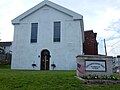
In 2012, the Souls Harvest Baptist Church relocated to New Philadelphia from Port Carbon. They are now located at the corner of Kimber and Clay streets in the building that once housed a Methodist church. This building is the oldest building in town.[ citation needed ]
Strasburg is a borough in Lancaster County, Pennsylvania, United States. It developed as a linear village stretching approximately 2 miles (3 km) along the Great Conestoga Road, later known as the Strasburg Road. The population was 3,117 at the 2020 census.
Carnegie is a borough in Allegheny County, Pennsylvania, United States. The population was 8,134 in the 2020 census. It is part of the Pittsburgh metropolitan area.
Ambridge is a borough in Beaver County, Pennsylvania, United States. Incorporated in 1905 as a company town by the American Bridge Company, Ambridge is located 16 miles (25 km) northwest of Pittsburgh, along the Ohio River. The population was 6,972 at the 2020 census.
Avondale is a borough in Chester County, in southeastern Pennsylvania, United States. The population was 1,272 at the 2020 census.
Houtzdale is a borough in Clearfield County, Pennsylvania, United States. The population was 764 at the 2020 census.
Paxtang is a borough in Dauphin County, Pennsylvania, United States. As of the 2020 census it had a population of 1,640. The borough is a suburb of Harrisburg and is one of the earliest colonial settlements in South Central Pennsylvania.
East Lansdowne is a borough in Delaware County Pennsylvania, United States. The population was 2,714 at the 2020 census.
Linwood is a census-designated place (CDP) in Delaware County, Pennsylvania, United States. The population was 3,281 at the 2010 census.
Lower Chichester Township is a township in Delaware County, Pennsylvania, United States. The population was 3,469 at the 2010 census. It contains the census designated place of Linwood.
Sharon Hill is a borough in Delaware County, Pennsylvania, United States. The population was 5,697 at the 2010 census. Currently the population stands at 6,356 residents.
Trainer is a borough in Delaware County, Pennsylvania, United States. The population was 1,828 at the 2010 census, down from 1,901 at the 2000 census. The borough was named after David Trainer, a wealthy textile manufacturer.
Yeadon is a borough in Delaware County, Pennsylvania, United States. It borders the city of Philadelphia. The population was 11,443 at the 2010 census.
Hokendauqua is an unincorporated community and census-designated place (CDP) in Whitehall Township in Lehigh County, Pennsylvania, United States. The population of Hokendauqua was 3,340 as of the 2020 census. Hokendauqua is a suburb of Allentown, Pennsylvania in the Lehigh Valley metropolitan area, which had a population of 861,899 and was the 68th-most populous metropolitan area in the U.S. as of the 2020 census.
McEwensville is a borough in Northumberland County, Pennsylvania, United States. The population was 298 during the 2020 census.
Auburn is a borough in Schuylkill County, Pennsylvania, United States. The population was 663 at the 2020 census.
Cressona is a borough in Schuylkill County, Pennsylvania. Formed in 1857 from part of North Manheim Township, it was founded by and named for John Chapman Cresson, a Philadelphia civil engineer and manager of the Schuylkill Navigation Company, president of the Mine Hill and Schuylkill Haven Railroad, and the chief engineer of Fairmount Park in Philadelphia.
Girardville is a borough in Schuylkill County, Pennsylvania, United States, 58 miles (93 km) northwest of Reading. Anthracite coal deposits are in the region. Coal-mining provided employment and incomes for many of the 3,666 people who lived there in 1900. In 1910, 4,396 individuals called it home. The population was 1,519 at the 2010 census. It was founded in 1832 and is named after Stephen Girard of Philadelphia, who purchased large land holdings in and around the town. It was incorporated as a borough in 1872.
Port Carbon is a borough of Schuylkill County, Pennsylvania, United States, located two miles (3 km) northeast of Pottsville. It is in a coal-mining area. In the past, ironworks had been a feature of the borough. In 1900, 2,168 people lived here and, in 1910, 2,678. The population was 1,815 at the 2020 census.
Shenandoah is a borough in Schuylkill County in the Coal Region of Pennsylvania. It is distinct from Shenandoah Heights, which is part of West Mahanoy Township immediately to the north. As of 2021, the borough's population was 4,247.
St. Clair is a borough in Schuylkill County, Pennsylvania, United States. It is located 2 mi (3.2 km) north of Pottsville in the southern Coal Region. Extensive deposits of hard coal are present.