Cumbola, Pennsylvania | |
|---|---|
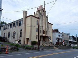 Market Street (U.S. Route 209) in Cumbola. New Life In Christ Ministries. | |
 Cumbola  Cumbola | |
| Coordinates: 40°42′42″N76°08′18″W / 40.71167°N 76.13833°W | |
| Country | United States |
| State | Pennsylvania |
| County | Schuylkill |
| Area | |
• Total | 0.40 sq mi (1.03 km2) |
| • Land | 0.40 sq mi (1.03 km2) |
| • Water | 0.00 sq mi (0.00 km2) |
| Population | |
• Total | 371 |
| • Density | 932.16/sq mi (360.05/km2) |
| Time zone | UTC-5 (Eastern (EST)) |
| • Summer (DST) | UTC-4 (EDT) |
| ZIP code | 17930 |
| Area code | 570 |
| FIPS code | 42-17680 |
Cumbola is a Village and census-designated place [3] located in Blythe Township, Schuylkill County in the state of Pennsylvania, United States. The community is located between the boroughs of New Philadelphia and Port Carbon along U.S. Route 209. As of the 2010 census [4] [ full citation needed ] the population was 443 residents.
