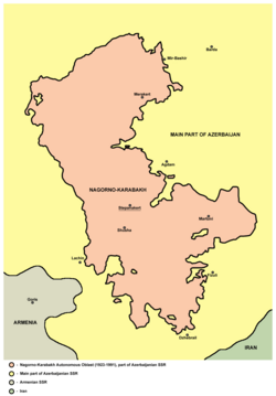
Nagorno-Karabakh Autonomous Oblast

Last updated

Nagorno-Karabakh Autonomous Oblast
Autonomous oblast of the Azerbaijan Soviet Socialist Republic
1923–1991
Location Nagorno-Karabakh2.png
Capital Stepanakert
Area 
 1989 [1]
4,388 km2 (1,694 sq mi)
Population 
 1989 [2]
189,085
  Type Autonomous Oblast
History 
 Established
7 July 1923
 Abolished
26 November 1991
Preceded by
Succeeded by
Flag of Transcaucasian SFSR (1925-1936).svg Transcaucasian SFSR
Republic of Nagorno-Karabakh Flag of Armenia.svg
Azerbaijan Flag of Azerbaijan (1991-2013).svg

The Nagorno-Karabakh Autonomous Oblast (NKAO) [lower-alpha 1] was an autonomous oblast within the Azerbaijan Soviet Socialist Republic that was created on July 7, 1923. Its capital was the city of Stepanakert. The leader of the oblast was the First Secretary of the Nagorno-Karabakh Autonomous Oblast Committee of the Communist Party of Azerbaijan. The majority of the population were ethnic Armenians. [3] [4] [5]

Contents

History

Principal cities of the Oblast Nagorno Karabakh03.png
Principal cities of the Oblast

The area was disputed between Armenia and Azerbaijan during their short-lived independence from 1918 and 1920. After the Sovietization of Armenia and Azerbaijan, the Kavbiuro organisation decided to keep the area within the Azerbaijan SSR whilst granting it broad regional autonomy. [6] Initially, the principal city of Karabakh, Shusha, and its surrounding villages were to be excluded from the autonomy as they were predominantly Azerbaijani, particularly after the massacre and expulsion of the majority Armenian population of Shusha—this decision was later reversed in 1923 when Shusha was decided to join the NKAO despite protests from Muslim villages who favoured its inclusion into the Kurdistan uezd instead. [7]

On July 7, 1923, Nagorno-Karabakh Autonomous Oblast was created and the capital was moved to Stepanakert. [8] At the time of its formation, its area was 4,161 km2 (1,607 sq mi). [8] According to the 1926 census, the population of the region was 125,200 people, among whom the Armenians accounted for 89.2 percent. However, by 1989, the share of Armenians dropped to 76.9 percent of the population of the autonomous region. [9] Reasons for this include the policy of Soviet Azerbaijani authorities to settle Azerbaijanis in the region and some out-migration of Karabakh Armenians, as well as the generally higher birthrate among Azerbaijanis than among Armenians. [10]

Although the question of Nagorno-Karabakh's status did not become a major public issue until the mid-1980s, Armenian intellectuals, Soviet Armenian and Karabakh Armenian leadership periodically made appeals to Moscow for the region's transfer to Soviet Armenia. [10] In 1945, the leader of Soviet Armenia Grigory Arutinov appealed to Stalin to attach the region to Soviet Armenia, which was rejected. [10] In 1965, thirteen Karabakh Armenian party officials wrote to Soviet leadership with their grievances about the attitude of Soviet Azerbaijani officials towards the NKAO. Many of these Karabakh Armenian officials were dismissed or moved to Armenia. [10] The rise of Heydar Aliyev to the leadership of the Azerbaijani SSR in 1969 saw increasing attempts to tighten Baku's control over the autonomous region. In 1973–74 Aliyev purged the entire leadership of the NKAO, who were regarded as Armenian nationalists. He appointed Boris Kevorkov, an Armenian from outside Karabakh, as the First Secretary of the Nagorno-Karabakh Autonomous Oblast Committee of the Communist Party of Azerbaijan. [10]

In 1977, the prominent Armenian author Sero Khanzadyan wrote an open letter to Leonid Brezhnev calling for Nagorno-Karabakh's annexation to Soviet Armenia. [11]

Administrative divisions

There were five administrative divisions or raions in the NKAO :

Demographics

Historical ethnic composition of the Nagorno-Karabakh Autonomous Oblast in 1921–1989
Ethnic group1921 [12] [13] 1923 [14] [12] 1925 [14] 1926 [14] [15] 1939 [14] [16] 1959 [14] [17] 1970 [14] [18] 1979 [14] [19] 1989 [20]
Number%Number%Number%Number%Number%Number%Number%Number%Number%
Armenians 122,71588.62149,60094.8142,47090.28111,69489.24132,80088.04110,05384.39121,06880.54123,07675.89145,45076.92
Azerbaijanis [lower-alpha 2] 15,44411.157,7004.915,2619.6712,59210.0614,0539.3217,99513.8027,17918.0837,26422.9840,68821.52
Russians 3070.225000.3460.035960.483,1742.101,7901.371,3100.871,2650.781,9221.02
Ukrainians 300.02350.034360.292380.181930.131400.094160.22
Belarusians 120.01110.01320.02350.02370.02790.04
Greeks 680.05740.05670.05330.02560.03720.04
Tatars 60.00290.02360.03250.02410.03640.03
Georgians 50.00250.02160.01220.01170.01570.03
Others1510.122350.161790.144480.302850.183370.18
TOTAL138,466100.00157,800100.0157,807100.00125,159100.00150,837100.00130,406100.00150,313100.00162,181100.00189,085100.00

First Secretaries

The First Secretary of the Nagorno-Karabakh Autonomous Oblast Committee of the Communist Party of Azerbaijan was the Communist Party of Azerbaijan's head and highest executive power within the oblast. The position was created in July 1923, and abolished on August 27, 1990. The position of First Secretary was de facto appointed by the Politburo of the Soviet Union or by the General Secretary of the Communist Party of the Soviet Union. Below is a list of office-holders:

NameTerm of OfficeLifespan
StartEnd
First Secretaries of the Oblast Committee of the Communist Party
Sero Manutsyan July 1923December 1923
Akop Bendzhanyan December 1923April 1924
Nikolai Sarkisov April 1924October 1924
Hayk Silanyan October 19241925 ?–1938
Artvazd Saakyants 192519291895–1939
M.K. Danilyan 1929December 1929
Ashot Karamyan 1929May 19301898–?
 ?May 19301937
Mikhail Manukyants 193719401909–1968
 ?19401942
Yegishe Grigoryan October 194219461902–?
Tigran Grigoryan 1946 ?
Yegishe Grigoryan 1952December 19581902–?
Nikolay Shakhnazarov December 1958October 19621908–
Gurgen Melkumyan October 1962June 19731915–
Boris Kevorkov June 1973February 24, 19881932–1998
Genrikh Poghosyan February 24, 1988January 20, 19891931–2000
Vagan Gabrielyan January 20, 1989August 27, 19901936–

Abolition

Location of the Oblast within the area claimed by the Republic of Artsakh. Ani Location Artsakh en.gif
Location of the Oblast within the area claimed by the Republic of Artsakh.

A conflict between the Armenians in the oblast and the government of the Azerbaijan SSR broke out in 1987. The fighting escalated into the First Nagorno-Karabakh War by the end of 1991. On 26 November 1991, the Supreme Soviet of the Azerbaijan Republic abolished the autonomous status of the oblast. Its internal administrative divisions were also abolished, and its territory was split up and redistributed amongst the neighbouring administrative rayons of Khojavend, Tartar, Goranboy, Shusha, and Kalbajar. [21] In response, the majority Armenian population of the oblast declared their independence as the Nagorno-Karabakh Republic which was supported by Armenia. [22] [23] [24]

See also

Notes

    • Russian: Нагорно-Карабахская автономная область (НКАО), romanized: Nagorno-Karabakhskaya avtonomnaya oblast' (NKAO)
    • Azerbaijani: Dağlıq Qarabağ Muxtar Vilayəti (DQMV)
    • Armenian: Լեռնային Ղարաբաղի Ինքնավար Մարզ (ԼՂԻՄ), romanized: Lerrnayin Gharabaghi Ink’navar Marz (LGhIM)
  1. Until 1936, Azerbaijanis were registered as Tyurki.

Related Research Articles

<span class="mw-page-title-main">Nagorno-Karabakh</span> Geopolitical region in Azerbaijan

Nagorno-Karabakh is a region in Azerbaijan, covering the southeastern stretch of the Lesser Caucasus mountain range. Part of the greater region of Karabakh, it spans the area between Lower Karabakh and Syunik. Its terrain mostly consists of mountains and forestland.

<span class="mw-page-title-main">Stepanakert</span> City in Nagorno-Karabakh, Azerbaijan

Stepanakert or Khankendi is a ghost city in the Nagorno-Karabakh region of Azerbaijan. The city was under the control and the capital city of the breakaway Republic of Artsakh prior to the 2023 Azerbaijani offensive in the region. The city is located in a valley on the eastern slopes of the Karabakh mountain range, on the left bank of the Qarqarçay (Karkar) river.

<span class="mw-page-title-main">Karakalpak Autonomous Soviet Socialist Republic</span> 1932–1991 autonomous republic of the Uzbek SSR, Soviet Union

The Karakalpak Autonomous Soviet Socialist Republic, also known as Soviet Karakalpakstan or simply Karakalpakstan, was an autonomous republic within the Soviet Union. Until 20 July 1932, it was called the Karakalpak Autonomous Oblast. On 5 December 1936, it was moved from the Russian SFSR to the Uzbek SSR. It was the only ASSR in Soviet Central Asia.

<span class="mw-page-title-main">Fuzuli (city)</span> City in Azerbaijan

Fuzuli is a city and the capital of the Fuzuli District of Azerbaijan.

Operation Ring, known in Azerbaijan as Operation Chaykand was the codename for the May 1991 military operation conducted by the Soviet Army, Internal Troops of the Ministry of Internal Affairs (MVD) of the USSR and OMON units of the Azerbaijan SSR in the Khanlar and Shahumyan districts of the Azerbaijani SSR, the Shusha, Martakert and Hadrut districts of the Nagorno-Karabakh Autonomous Oblast, and along the eastern border of the Armenian SSR in the districts of Goris, Noyemberyan, Ijevan and Shamshadin. Officially dubbed a "passport checking operation," the ostensible goal of the operation was to disarm "illegal armed formations" in and around Nagorno-Karabakh, referring to irregular Armenian military detachments that had been operating in the area. The operation involved the use of ground troops accompanied by a complement of military vehicles, artillery and helicopter gunships to be used to root out the self-described Armenian fedayeen.

<span class="mw-page-title-main">Karabakh</span> Region in Azerbaijan and Armenia

Karabakh is a geographic region in present-day southwestern Azerbaijan and eastern Armenia, extending from the highlands of the Lesser Caucasus down to the lowlands between the rivers Kura and Aras. It is divided into three regions: Highland Karabakh, Lowland Karabakh, and the eastern slopes of the Zangezur Mountains.

Syrkhavend or Nor Ghazanchi is a village located in the Agdam District of Azerbaijan, in the disputed region of Nagorno-Karabakh. The village had an Azerbaijani majority prior to their expulsion during the First Nagorno-Karabakh War.

<span class="mw-page-title-main">Jamilli</span> Place in Khojaly, Azerbaijan

Jamilli is a village in the Khojaly District of Azerbaijan. The village had an Azerbaijani majority prior to their expulsion during the First Nagorno-Karabakh War. Prior to the 2023 Azerbaijani offensive, it was de facto controlled by the Republic of Artsakh.

This page lists in alphabetical order articles related to the Republic of Artsakh and Nagorno-Karabakh region. For a topically arranged list of articles, please see Outline of the Republic of Artsakh.

<span class="mw-page-title-main">Demographics of the Republic of Artsakh</span> Demographics of Artsakh

Demographic features of the population of Artsakh include population density, ethnicity, education level, health of the populace, economic status, religious affiliations, and other aspects.

<span class="mw-page-title-main">Umudlu, Nagorno-Karabakh</span> Place

Umudlu or Aknaberd is a village located in the Tartar District of Azerbaijan, in the disputed region of Nagorno-Karabakh. The village had an Azerbaijani-majority population prior to their exodus during the First Nagorno-Karabakh War.

Krasnoarmeysky was an inhabited locality in Chaunsky District of Chukotka Autonomous Okrug, Russia. Population: 0 ; 2,299 (1989 Census)

<span class="mw-page-title-main">Kurds in Azerbaijan</span> Ethnic group

The Kurds in Azerbaijan,, form a part of the historically significant Kurdish population in the post-Soviet space. Kurds established a presence in the Caucasus with the establishment of the Kurdish Shaddadid dynasty in the tenth and eleventh centuries. Some Kurdish tribes were recorded in Karabakh by the end of the sixteenth century. However, virtually the entire contemporary Kurdish population in the Republic of Azerbaijan descends from migrants from 19th-century Qajar Iran.

<span class="mw-page-title-main">Shusha District (NKAO)</span> District in Nagorno-Karabakh Autonomous Oblast

Shusha District was an administrative unit within the former Nagorno-Karabakh Autonomous Oblast (NKAO) of the Azerbaijan Soviet Socialist Republic.

<span class="mw-page-title-main">Law on Abolishment of Nagorno-Karabakh Autonomous Oblast</span> 1991 Azerbaijani law stripping Nagorno-Karabakh of autonomous status

The Law on Abolishment of Nagorno-Karabakh Autonomous Oblast was a motion passed by the Supreme Soviet of the Republic of Azerbaijan and signed into law by the President of Azerbaijan Ayaz Mutalibov on November 26, 1991. The law had been prompted by a vote in the National Assembly of the Nagorno-Karabakh Autonomous Oblast in favor of uniting itself with the Armenian SSR on 20 February 1988. The vote was followed by an independence referendum in 1991 which was boycotted by the Azerbaijani population of the Oblast; most voted in favor of independence. While these votes and elections had mainly been conducted in a relatively peaceful manner, in the following months, as the Soviet Union disintegrated, it gradually grew into an increasingly violent conflict between ethnic Armenians and ethnic Azerbaijanis. Both sides claimed that ethnic cleansing was being carried out. The declaration of secession from Azerbaijan was the final result of a territorial conflict regarding the land.

Mass deportation of Azerbaijanis from Armenia took place several times throughout the 20th century, and sometimes some of them have been described by some authors as acts of forced resettlement and ethnic cleansing.

<span class="mw-page-title-main">Russians in Azerbaijan</span> Ethnic group in Azerbaijan

Russians in Azerbaijan are the second largest ethnic minority in Azerbaijan and is also the largest Russian community in the South Caucasus and one of the largest outside of Russia. Although in decline, the community still numbers 71,000 people as of 2019. Since their arrival at the beginning of the 19th century, the Russians have played an important role in all spheres of life, particularly during the Czarist and Soviet period, especially in the capital city of Baku.

<span class="mw-page-title-main">Kurds in Georgia</span> Ethnic group in Georgia

The Kurds in Georgia form a major part of the historically significant Kurdish population in the post-Soviet space, and are members of the eponymous ethnic group that are citizens of Georgia. In the 20th century, most Kurds fled religious persecution in the Ottoman Empire to the Russian Empire. The return of their Kurdish surnames needs effort according to a Kurdish activist in Georgia. The Kurds also have their own schools, school books and a printing press in Georgia. Illiteracy among them disappeared in the early 1900s. Kurds in Georgia are politically neutral; however, in 1999 they staged a huge demonstration in Tbilisi, demanding the release of the founder of the Kurdistan Workers' Party, Abdullah Öcalan. Kurds in Georgia today use Cyrillic script. Earlier, in the 1920s, they used the Latin script.

Tatars in Azerbaijan are Azerbaijani citizens and people of Tatar origin. According to the 2009 census, 25,882 Tatars live in the Republic of Azerbaijan. This is 0.29% of the total population.

<span class="mw-page-title-main">1988 violence in Shusha and Stepanakert</span> Expulsion of Armenians from Shusha and Azerbaijanis from Stepanakert

The 1988 violence in Shusha and Stepanakert was the expulsion of the ethnic Armenian population of Shusha and the ethnic Azerbaijani population of Stepanakert, in the Nagorno-Karabakh Autonomous Oblast in the Azerbaijani SSR, Soviet Union, from September 18 to 20, 1988. During the violence, 33 Armenians and 16 Azerbaijanis were wounded, more than 30 houses hed been set on fire, and a 61-year-old Armenian was killed. At the end of the violence, 3,117 ethnic Azerbaijanis were forced to leave Stepanakert.

References

  1. (in Russian) НАГОРНО-КАРАБАХСКАЯ АО (1989 г.) Archived September 16, 2011, at the Wayback Machine
  2. (in Russian) НАГОРНО-КАРАБАХСКАЯ АО (1989 г.) Archived September 16, 2011, at the Wayback Machine
  3. Ardillier-Carras, Françoise (2006). "Sud-Caucase: conflit du Karabagh et nettoyage ethnique" [South Caucasus: Nagorny Karabagh conflict and ethnic cleansing]. Bulletin de l'Association de Géographes Français (in French). 83 (4): 409–432. doi:10.3406/bagf.2006.2527. Archived from the original on December 12, 2020. Retrieved January 13, 2023.
  4. "Conflicts in the Caucasus". UNHCR publication for CIS Conference (Displacement in the CIS). United Nations High Commissioner for Refugees. 1996. Archived from the original on September 22, 2020. Retrieved January 13, 2023.
  5. Yamskov, A. N. (1991). "Ethnic Conflict in the Transcausasus: The Case of Nagorno-Karabakh". Theory and Society. Vol. 20, no. 5. p. 659.
  6. "Q&A with Arsène Saparov: No Evidence that Stalin 'Gave' Karabakh to Aхerbaijan". armenian.usc.edu. December 10, 2018. Archived from the original on December 15, 2020. Retrieved January 13, 2023. Of all the documents I have seen, there is no direct evidence of Stalin doing or saying something in those 12 days in the summer of 1921 that [resulted in this decision on Karabakh]. A lot of people just assume that since Stalin was an evil person, it would be typical of someone evil to take a decision like that.
  7. Həmid, Tural (December 15, 2020). "Dağlıq Qarabağın sərhədləri necə cızılırdı?" [How were the borders of Nagorno-Karabakh drawn?]. Azlogos. Archived from the original on January 13, 2023. Retrieved August 23, 2022.
  8. 1 2 Атлас Союза Советских Социалистических Республик[Atlas of the Union of Soviet Socialist Republics]. Moscow: Central Executive Committee of the USSR. 1928. The Autonomous Region of Nagorno-Karabakh, which is part of the SSR of Azerbaijan, was formed by the decree of the AzCEC 7 / VI 1923 from Armenian parts of the former Jevanshir, Shulgan, Karyaginsky, and Kubatly uyezds. The territory of the Region is 4.161 sq. km. According to the administrative division on 1 / I of 1927, it is divided into 5 sections or parishes. Its administrative and political center is mountains. Stepanakert (formerly the village of Khankendy). Another city of the Region is Shusha.
  9. "All-Union Population Census of 1926. Ethnic composition of the population by regions of the republics of the USSR". demoscope.ru. 1926. Archived from the original on November 28, 2020. Retrieved January 13, 2023.
  10. 1 2 3 4 5 de Waal, Thomas (2003). Black Garden: Armenia and Azerbaijan through Peace and War. New York and London: New York University Press. pp. 3 & 137–140. ISBN   0-8147-1944-9.
  11. Sanjian, Ara (January 6, 2021). "The Armenian Diasporan Press on Mountainous Karabagh, 1923-1985". entriessas.com. Entries of the Society for Armenian Studies. Archived from the original on January 13, 2023. Retrieved January 21, 2021. This 'silence' was only broken in the Diaspora with the publication of Yerevan-based novelist Sero Khanzadyan's open letter to the Soviet leader Leonid Brezhnev in 1977, demanding Mountainous Karabagh's annexation to Soviet Armenia.
  12. 1 2 Cory D., Welt (2004). Explaining ethnic conflict in the South Caucasus: Mountainous Karabagh, Abkhazia, and South Ossetia (PDF). Massachusetts Institute of Technology. p. 77. OCLC   59823134. Archived (PDF) from the original on September 11, 2022. Out of a population of approximately 20,000, at least several hundred were killed; the rest were forced to flee. In the fighting that followed, several nearby villages were also razed.{{cite book}}: CS1 maint: date and year (link)
  13. "Перепись населения АзССР в 1921 г." [Census of the population of the AzSSR in 1921]. karabagh.am. Archived from the original on May 26, 2011. Retrieved June 26, 2022.
  14. 1 2 3 4 5 6 7 Beglaryan, Ashot. "The population of Nagorno-Karabakh for a year. Union of Armenians of Russia - Nagorno-Karabakh Republic. Excursion into history". losevskaya.ru. Stepanakert. Archived from the original on October 31, 2022. Retrieved October 31, 2022.
  15. Всесоюзная перепись населения 1926 года. Национальный состав населения по регионам республик СССР Archived June 5, 2016, at the Wayback Machine Демоскоп
  16. Всесоюзная перепись населения 1939 года. Распределение городского и сельского населения областей союзных республик по национальности и полу Archived June 5, 2016, at the Wayback Machine Демоскоп
  17. Всесоюзная перепись населения 1959 года. Городское и сельское население областей республик СССР (кроме РСФСР) по полу и национальности Archived June 5, 2016, at the Wayback Machine Демоскоп
  18. Всесоюзная перепись населения 1970 года. Городское и сельское население областей республик СССР (кроме РСФСР) по полу и национальности Archived June 5, 2016, at the Wayback Machine Демоскоп
  19. Всесоюзная перепись населения 1979 года. Городское и сельское население областей республик СССР (кроме РСФСР) по полу и национальности Archived June 5, 2016, at the Wayback Machine Демоскоп
  20. Всесоюзная перепись населения 1989 года.Распределение городского и сельского населения областей республик СССР по полу и национальности Archived June 5, 2016, at the Wayback Machine Демоскоп
  21. Svante Cornell, Turkey and the Conflict in Nagorno Karabakh: A Delicate Balance Archived June 10, 2007, at the Wayback Machine , in Middle Eastern Studies Journal Vol 34, No. 1 (London: Frank Cass Publications, January 1998), pp. 51–72
  22. Oskanian, Kevork (September 29, 2020). "Nagorno-Karabakh: are Armenia and Azerbaijan sliding towards all-out war?". The Conversation. Archived from the original on November 29, 2020. Retrieved October 19, 2020.
  23. Minasyan, Karen (October 2, 2020). "Why Nagorno-Karabakh? The history (both ancient and modern) that fuels the deadly conflict between Armenia and Azerbaijan". meduza.io. Archived from the original on December 21, 2020. Retrieved October 19, 2020.
  24. Department Of State. The Office of Electronic Information, Bureau of Public Affairs. "1993 UN Security Council Resolutions on Nagorno-Karabakh". 2001-2009.state.gov. Archived from the original on January 22, 2020. Retrieved October 19, 2020.

39°48′55″N46°45′07″E / 39.8153°N 46.7519°E / 39.8153; 46.7519