Chuvashia, officially known as Chuvash Republic — Chuvashia, is a republic of Russia located in Eastern Europe. It is the homeland of the Chuvash people, a Turkic ethnic group. Its capital is the city of Cheboksary. As of the 2010 Census, its population was 1,251,619.

The Volga German Autonomous Soviet Socialist Republic, abbreviated as the Volga German ASSR, was an autonomous republic of the Russian SFSR. Its capital city was Engels located on the Volga River. As a result of the German invasion of the Soviet Union in 1941, the republic was abolished and Volga Germans were exiled.

The Turkestan Autonomous Soviet Socialist Republic, originally called the Turkestan Socialist Federative Republic, was an autonomous republic of the Russian Soviet Federative Socialist Republic located in Soviet Central Asia which existed between 1918 and 1924. Uzbeks were the preeminent nation of the Turkestan ASSR. Tashkent was the capital and largest city in the region.

Several different governments controlled the Crimean Peninsula during the period of the Soviet Union, from the 1920s to 1991. The government of Crimea from 1921 to 1936 was the Crimean Autonomous Socialist Soviet Republic, which was an Autonomous Soviet Socialist Republic within the Russian Soviet Federative Socialist Republic (SFSR); the name was altered slightly to the Crimean Autonomous Soviet Socialist Republic from 1936 to 1945.

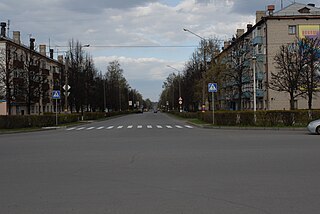
Novocheboksarsk is a city in Chuvashia, Russia, located on the southern bank of the Volga River, about 3 kilometers (1.9 mi) east of Cheboksary, the capital city of the republic. It had a population of 124,097 (2010 Census); 125,857 (2002 Census); 114,760 (1989 Soviet census).

Kanash is a town in the Chuvash Republic, Russia, located at a major railway junction 76 kilometers (47 mi) from Cheboksary, the capital of the republic. Population: 45,607 (2010 Census); 50,593 (2002 Census); 54,585 (1989 Soviet census).

When the Soviet Union existed, different governments had ruled the northern Caucasus regions of Chechnya and Ingushetia. Within the Mountain Autonomous Socialist Soviet Republic, later annexed into the Russian Socialist Federative Soviet Republic, they were known as the Chechen Autonomous Oblast and the Ingush Autonomous Oblast, which were unified on January 15, 1934, to form the Checheno-Ingush Autonomous Oblast. It was elevated to an autonomous republic as the Checheno-Ingush Autonomous Soviet Socialist Republic from 1936 to 1944 and again from 1957 to 1993. Its capital was Grozny.

The Chuvash Autonomous Soviet Socialist Republic was an autonomous republic of the Russian SFSR within the Soviet Union.

Adyghe Autonomous Oblast was an autonomous oblast within Krasnodar Krai, Soviet Union. It existed from 1922 to 1991.

The Udmurt Autonomous Oblast was formed on 4 November 1920 as the Votyak Autonomous Oblast, "Votyak" being an obsolete name for the Udmurt people. It was renamed Udmurt Autonomous Oblast on 1 January 1932 and was reorganized into the Udmurt ASSR on 28 December 1934. This became the Udmurt Republic on 20 September 1990.

The Gorno-Altai Autonomous Oblast was an autonomous oblast of the Soviet Union, inhabited by the Altai people. Formed as the Oyrot Autonomous Oblast in 1922, it was later renamed in 1948.

The Kalmyk Autonomous Soviet Socialist Republic was an autonomous republic of the Russian SFSR that existed at two periods of time. Its administrative center was Elista.

The Nagorno-Karabakh Autonomous Oblast (NKAO) was an autonomous oblast within the Azerbaijan Soviet Socialist Republic that was created on July 7, 1923. Its capital was the city of Stepanakert. The majority of the population were ethnic Armenians.
Yadrin is a town and the administrative center of Yadrinsky District of the Chuvash Republic, Russia. Yadrin is located on the left bank of the Sura River, 86 kilometers (53 mi) southwest of Cheboksary, the capital of the republic. Population: 9,614 (2010 Census); 10,573 (2002 Census); 10,149 (1989 Soviet census).

Alikovsky District is an administrative and municipal district (raion), one of the twenty-one in the Chuvash Republic, Russia. It is located in the northwestern central part of the republic and borders with Morgaushsky and Yadrinsky Districts in the north, Krasnoarmeysky District in the east, Vurnarsky and Shumerlinsky Districts in the south, and with Krasnochetaysky District in the west. The area of the district is 554.1 square kilometers (213.9 sq mi). Its administrative center is the rural locality of Alikovo. Population: 18,282 (2010 Census); 21,745 (2002 Census); 23,575 (1989 Soviet census). The population of Alikovo accounts for 14.5% of the district's total population.

Morgaushsky District is an administrative and municipal district (raion), one of the twenty-one in the Chuvash Republic, Russia. It is located in the north of the republic and borders with the Mari El Republic in the north, Cheboksarsky District in the east, Alikovsky District in the south, and with Yadrinsky District in the west. The area of the district is 845.3 square kilometers (326.4 sq mi). Its administrative center is the rural locality of Morgaushi. Population: 34,884 (2010 Census); 37,127 (2002 Census); 38,465 (1989 Soviet census).

Yadrinsky District is an administrative and municipal district (raion), one of the twenty-one in the Chuvash Republic, Russia. It is located in the northwest of the republic and borders with the Mari El Republic in the north, Morgaushsky District in the east, Alikovsky and Krasnochetaysky Districts in the south, and with Nizhny Novgorod Oblast in the west. The area of the district is 897.5 square kilometers (346.5 sq mi). Its administrative center is the town of Yadrin. Population: 29,965 (2010 Census); 34,456 (2002 Census); 36,745 (1989 Soviet census). The population of Yadrin accounts for 32.1% of the district's total population.

Krasnochetaysky District is an administrative and municipal district (raion), one of the twenty-one in the Chuvash Republic, Russia. It is located in the west of the republic and borders with Yadrinsky District in the north, Morgaushsky District in the east, Alikovsky and Shumerlinsky Districts in the south, and with Nizhny Novgorod Oblast in the west. The area of the district is 691.6 square kilometers (267.0 sq mi). Its administrative center is the rural locality of Krasnye Chetai. Population: 16,941 (2010 Census); 21,117 (2002 Census); 24,589 (1989 Soviet census). The population of Krasnye Chetai accounts for 15.5% of the district's total population.

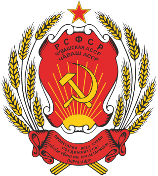
The national emblem of the Chuvash Autonomous Soviet Socialist Republic was adopted in 1937 by the government of the Chuvash Autonomous Soviet Socialist Republic. The emblem is identical to the emblem of the Russian Soviet Federative Socialist Republic.

The Erzya-Moksha Autonomy was a name of an administrative division of the Russian SFSR, Soviet Union approved by Executive Committee of Erzya-Moksha Autonomous oblast before July 16, 1928. The Executive Committee name didn't change till 1930. The conventional name of the Oblast was changed to Mordvin Okrug on July 16, 1928. The administrative centre first was planned to be the oldest Oblast city Temnikov but it was established in Saransk because of the railroad absence in Temnikov.


