Tsivilsky District | |
|---|---|
| Other transcription(s) | |
| • Chuvash | Çĕрпӳ районӗ |
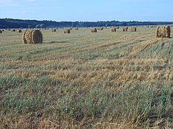 August harvest in Tsivil River valley, Tsivilsky District | |
 Flag  Coat of arms | |
 Location of Tsivilsky District in the Chuvash Republic | |
| Coordinates: 55°49′16″N47°12′29″E / 55.821°N 47.208°E | |
| Country | Russia |
| Federal subject | Chuvash Republic [1] |
| Established | September 5, 1927 [2] |
| Administrative center | Tsivilsk [1] |
| Area | |
• Total | 790.8 km2 (305.3 sq mi) |
| Population | |
• Total | 36,772 |
| • Density | 46.50/km2 (120.4/sq mi) |
| • Urban | 36.7% |
| • Rural | 63.3% |
| Administrative structure | |
| • Administrative divisions | 1 Urban settlements, 16 Rural settlements |
| • Inhabited localities | 1 cities/towns, 138 rural localities |
| Municipal structure | |
| • Municipally incorporated as | Tsivilsky Municipal District [4] |
| • Municipal divisions [4] | 1 urban settlements, 16 rural settlements |
| Time zone | UTC+3 (MSK |
| OKTMO ID | 97641000 |
| Website | http://gov.cap.ru/main.asp?govid=74 |
Tsivilsky District [a] is an administrative [1] and municipal [4] district (raion), one of the twenty-one in the Chuvash Republic, Russia. It is located in the northeast of the republic and borders with Cheboksarsky District in the north and northwest, Mariinsko-Posadsky District in the northeast, Kanashsky District in the south, and with Krasnoarmeysky District in the west. The area of the district is 790.8 square kilometers (305.3 sq mi). [2] Its administrative center is the town of Tsivilsk. [1] Population: 36,772 (2010 Census); [3] 38,744 (2002 Census); [6] 37,581 (1989 Soviet census). [7] The population of Tsivilsk accounts for 36.7% of the district's total population. [3]