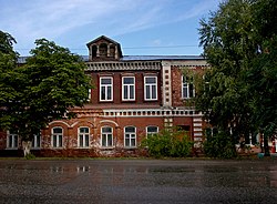
Tsivilsk is a town and the administrative center of Tsivilsky District of the Chuvash Republic, Russia, located 37 kilometers (23 mi) from the republic's capital city of Cheboksary, at the crossroads of the highways from Nizhny Novgorod to Kazan and from Tsivilsk to Ulyanovsk. Population: 13,479 (2010 Census); 12,967 (2002 Census); 10,053 (1989 Census).

Cheboksarsky District is an administrative and municipal district (raion), one of the twenty-one in the Chuvash Republic, Russia. It is located in the north of the republic and borders with the Mari El Republic in the north, Mariinsko-Posadsky District in the east, Tsivilsky and Krasnoarmeysky Districts in the south, and with Morgaushsky District in the west. The area of the district is 1,178.8 square kilometers (455.1 sq mi). Its administrative center is the urban locality of Kugesi. Population: 62,920 (2010 Census); 58,766 (2002 Census); 57,107 (1989 Census).

Shumerlya is a town in the Chuvash Republic, Russia, located on the right bank of the Sura River on the Nizhny Novgorod–Ulyanovsk highway. Population: 31,722 (2010 Census); 36,239 (2002 Census); 41,986 (1989 Census); 35,000 (1974).

Yadrinsky District is an administrative and municipal district (raion), one of the twenty-one in the Chuvash Republic, Russia. It is located in the northwest of the republic and borders with the Mari El Republic in the north, Morgaushsky District in the east, Alikovsky and Krasnochetaysky Districts in the south, and with Nizhny Novgorod Oblast in the west. The area of the district is 897.5 square kilometers (346.5 sq mi). Its administrative center is the town of Yadrin. Population: 29,965 (2010 Census); 34,456 (2002 Census); 36,745 (1989 Census). The population of Yadrin accounts for 32.1% of the district's total population.

Krasnochetaysky District is an administrative and municipal district (raion), one of the twenty-one in the Chuvash Republic, Russia. It is located in the west of the republic and borders with Yadrinsky District in the north, Morgaushsky District in the east, Alikovsky and Shumerlinsky Districts in the south, and with Nizhny Novgorod Oblast in the west. The area of the district is 691.6 square kilometers (267.0 sq mi). Its administrative center is the rural locality of Krasnye Chetai. Population: 16,941 (2010 Census); 21,117 (2002 Census); 24,589 (1989 Census). The population of Krasnye Chetai accounts for 15.5% of the district's total population.

Krasnoarmeysky District is an administrative and municipal district (raion), one of the twenty-one in the Chuvash Republic, Russia. It is located in the north of the republic and borders with Cheboksarsky District in the north, Tsivilsky District in the northeast, Kanashsky and Vurnarsky Districts in the south, and with Alikovsky and Morgaushsky Districts in the west. The area of the district is 456.3 square kilometers (176.2 sq mi). Its administrative center is the rural locality of Krasnoarmeyskoye. Population: 16,036 (2010 Census); 17,940 (2002 Census); 19,693 (1989 Census). The population of Krasnoarmeyskoye accounts for 26.6% of the district's total population.

Vurnarsky District is an administrative and municipal district (raion), one of the twenty-one in the Chuvash Republic, Russia. It is located in the center of the republic and borders with Alikovsky and Krasnoarmeysky Districts in the north, Kanashsky District in the east, Ibresinsky District in the south, and with Shumerlinsky District in the west. The area of the district is 1,012.6 square kilometers (391.0 sq mi). Its administrative center is the urban locality of Vurnary. Population: 35,850 (2010 Census); 41,417 (2002 Census); 44,864 (1989 Census). The population of Vurnary accounts for 28.1% of the district's total population.

Ibresinsky District is an administrative and municipal district (raion), one of the twenty-one in the Chuvash Republic, Russia. It is located in the southern central part of the republic and borders with Vurnarsky and Kanashsky Districts in the north, Komsomolsky District in the east, Batyrevsky and Alatyrsky Districts in the south, and with Shumerlinsky and Poretsky Districts in the west. The area of the district is 1,201.2 square kilometers (463.8 sq mi). Its administrative center is the urban locality of Ibresi. Population: 26,192 (2010 Census); 28,377 (2002 Census); 28,471 (1989 Census).

Kanashsky District is an administrative and municipal district (raion), one of the twenty-one in the Chuvash Republic, Russia. It is located in the eastern central part of the republic and borders with Tsivilsky and Krasnarmeysky Districts in the north, Urmarsky and Yantikovsky Districts in the east, Komsomolsky and Ibresinsky Districts in the south, and with Vurnarsky District in the west. The area of the district is 981.4 square kilometers (378.9 sq mi). Its administrative center is the town of Kanash. Population: 39,708 (2010 Census); 42,623 ; 46,236 (1989 Census).

Urmarsky District is an administrative and municipal district (raion), one of the twenty-one in the Chuvash Republic, Russia. It is located in the northeast of the republic and borders with Kozlovsky District in the north, Tsivilsky District in the northwest, Yantikovsky District in the south, and with Kanashsky District in the west. The area of the district is 598.3 square kilometers (231.0 sq mi). Its administrative center is the urban locality of Urmary. Population: 25,189 (2010 Census); 28,189 (2002 Census); 29,868 (1989 Census). The population of Urmary accounts for 22.5% of the district's total population.

Komsomolsky District is an administrative and municipal district (raion), one of the twenty-one in the Chuvash Republic, Russia. It is located in the southeast of the republic and borders with Kanashsky District in the north, Yalchiksky District and the Republic of Tatarstan in the east, Batyrevsky District in the south, and with Ibresinsky District in the west. The area of the district is 630.3 square kilometers (243.4 sq mi). Its administrative center is the rural locality of Komsomolskoye. Population: 26,951 (2010 Census); 27,273 (2002 Census); 28,627 (1989 Census). The population of Komsomolskoye accounts for 18.2% of the district's total population.

Batyrevsky District is an administrative and municipal district (raion), one of the twenty-one in the Chuvash Republic, Russia. It is located in the southeast of the republic and borders with Komsomolsky and Ibresinsky Districts in the north, Yalchiksky District in the east, Shemurshinsky District and the Republic of Tatarstan in the south, and with Alatyrsky District in the west. The area of the district is 944 square kilometers (364 sq mi). Its administrative center is the rural locality of Batyrevo. Population: 38,620 (2010 Census); 41,769 (2002 Census); 44,243 (1989 Census). The population of Batyrevo accounts for 14.1% of the district's total population.

Kozlovka is a town and the administrative center of Kozlovsky District of the Chuvash Republic, Russia, located on the right bank of the Volga River, near the borders with the Mari El Republic and the Republic of Tatarstan. Population: 10,359 (2010 Census); 13,054 (2002 Census); 12,708 (1989 Census).

Yantikovsky District is an administrative and municipal district (raion), one of the twenty-one in the Chuvash Republic, Russia. It is located in the east of the republic and borders with the Republic of Tatarstan in the south and east, Kanashsky District in the west, and with Urmarsky District in the north. The area of the district is 524.4 square kilometers (202.5 sq mi). Its administrative center is the rural locality of Yantikovo. Population: 16,421 (2010 Census); 18,580 (2002 Census); 20,017 (1989 Census). The population of Yantikovo accounts for 19.2% of the district's total population.

Alatyrsky District is an administrative and municipal district (raion), one of the twenty-one in the Chuvash Republic, Russia. It is located in the south of the republic. The area of the district is 1,940 square kilometers (750 sq mi). Its administrative center is the town of Alatyr. Population: 17,244 (2010 Census); 21,630 ; 26,007 (1989 Census).

Poretsky District is an administrative and municipal district (raion), one of the twenty-one in the Chuvash Republic, Russia. It is located in the southwest of the republic. The area of the district is 1,116.9 square kilometers (431.2 sq mi). Its administrative center is the rural locality of Poretskoye. Population: 13,992 (2010 Census); 17,311 ; 19,486 (1989 Census). The population of Poretskoye accounts for 41.6% of the district's total population.

Shemurshinsky District is an administrative and municipal district (raion), one of the twenty-one in the Chuvash Republic, Russia. It is located in the south and southwest of the republic. The area of the district is 799.1 square kilometers (308.5 sq mi). Its administrative center is the rural locality of Shemursha. Population: 14,759 (2010 Census); 16,588 ; 18,186 (1989 Census). The population of Shemursha accounts for 25.5% of the district's total population.
Novye Lapsary is an urban locality under the administrative jurisdiction of Leninsky City District of the town of republican significance of Cheboksary, the Chuvash Republic, Russia. Population: 6,955 (2010 Census); 7,655 (2002 Census); 5,691 (1989 Census).

Ibresi is an urban-type settlement and the administrative center of Ibresinsky District, Chuvashia, Russia. Population: 8,415 (2010 Census); 9,201 (2002 Census); 8,682 (1989 Census).
Kugesi is an urban-type settlement in Cheboksarsky District, the Chuvash Republic, Russia. Population: 11,917 (2010 Census); 11,658 (2002 Census); 9,540 (1989 Census).