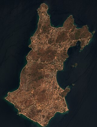
Satellite picture of Likoma island (right) and Chizumulu island (left).
Chizumulu Island is the smaller of two islands in Lake Malawi, the larger being the nearby Likoma island, which together make up the Likoma District. Both these islands lie just a few kilometres from Mozambique and are entirely surrounded by Mozambican territorial waters, but they belong to Malawi. They are therefore exclaves of Malawi. This came about because the islands were colonised by Anglicanmissionaries spreading east from Nyasaland, rather than by the Portuguese who colonised Mozambique. The British originally claimed the entire Lake Nyasa/Lake Malawi, but in 1954 signed an agreement with Portugal, which recognized the centre of the lake as the boundary between their holdings and Mozambique, and making these islands an enclave.[1]
Chizumulu can be reached by steamer from the port of Nkhata Bay on the mainland of Malawi. The MV Ilala steamer that weekly crosses Lake Malawi stops at Chizumulu. Smaller boats including dhows cross the strait between Likoma and Chizumulu.
The island supports a population of about 4,000 people. Like Likoma, the island imports most of its food from the mainland. There is electricity on the island from 6am-10pm (with a break between 12-2pm), and no road. However, there is a well-constructed path which runs around the outside of the island, which can be walked around in about three hours.
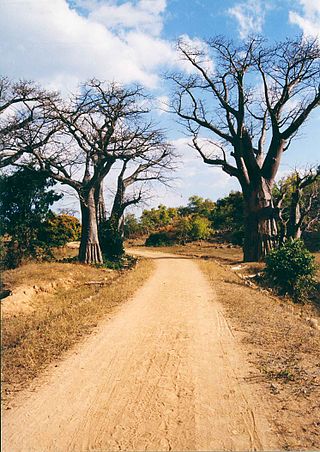
The island consists of two large hills, with a flatter area to the south. Cassava plantations cover much of the lower slopes of the hills, with the upper parts being forested. Many baobab trees are present.
The locals speak a Nkamanga dialect, a variety of Nyanja.[2]
The History of Malawi covers the area of present-day Malawi. The region was once part of the Maravi Empire. In colonial times, the territory was ruled by the British, under whose control it was known first as British Central Africa and later Nyasaland. It became part of the Federation of Rhodesia and Nyasaland. The country achieved full independence, as Malawi, in 1964. After independence, Malawi was ruled as a one-party state under Hastings Banda until 1994.
Transportation in Malawi is poorly developed. The country of almost 14 million has 39 airports, 6 with paved runways and 33 with unpaved runways. It has 797 kilometres of railways, all narrow-gauge and about 45 percent of its roads are paved. Though it is landlocked, Malawi also has 700 km (435 mi) of waterways on Lake Malawi and along the Shire River.
Mozambique, officially the Republic of Mozambique, is a country located in southeastern Africa bordered by the Indian Ocean to the east, Tanzania to the north, Malawi and Zambia to the northwest, Zimbabwe to the west, and Eswatini and South Africa to the southwest. The sovereign state is separated from the Comoros, Mayotte and Madagascar by the Mozambique Channel to the east. The capital and largest city is Maputo.
Lake Malawi, also known as Lake Nyasa in Tanzania and Lago Niassa in Mozambique, is an African Great Lake and the southernmost lake in the East African Rift system, located between Malawi, Mozambique and Tanzania.
Chinde is a town of Mozambique, and a port for the Zambezi valley. It is located on the Chinde River, and is an important fishing center. It exports copra and sugar, and had a population of 16,500 in 1980. Chinde lies in Chinde District of Zambezia Province.
The British Central Africa Protectorate (BCA) was a British protectorate proclaimed in 1889 and ratified in 1891 that occupied the same area as present-day Malawi: it was renamed Nyasaland in 1907. British interest in the area arose from visits made by David Livingstone from 1858 onward during his exploration of the Zambezi area. This encouraged missionary activity that started in the 1860s, undertaken by the Universities' Mission to Central Africa, the Church of Scotland and the Free Church of Scotland, and which was followed by a small number of settlers. The Portuguese government attempted to claim much of the area in which the missionaries and settlers operated, but this was disputed by the British government. To forestall a Portuguese expedition claiming effective occupation, a protectorate was proclaimed, first over the south of this area, then over the whole of it in 1889. After negotiations with the Portuguese and German governments on its boundaries, the protectorate was formally ratified by the British government in May 1891.
Chewa is a Bantu language spoken in Malawi and a recognised minority in Zambia and Mozambique. The noun class prefix chi- is used for languages, so the language is usually referred to as Chichewa and Chinyanja. In Malawi, the name was officially changed from Chinyanja to Chichewa in 1968 at the insistence of President Hastings Kamuzu Banda, and this is still the name most commonly used in Malawi today. In Zambia, the language is generally known as Nyanja or Cinyanja/Chinyanja '(language) of the lake'.
The Northern Region is a region of Malawi. It had a population of 2,289,780 in 2018, and covers an area of 26,931 km², making it the smallest region both by population and area. Its capital city is Mzuzu. Starting in the north and going clockwise, the Northern Region borders on Tanzania, Lake Malawi, Malawi's Central Region, and Zambia.
The Central Region of Malawi, population 7,523,340 (2018), covers an area of 35,592 km². Its capital city is Lilongwe, which is also the national capital. The region has an outlet on Lake Malawi and borders neighbouring countries Zambia and Mozambique. The Chewa people make up the majority of the population today.
Likoma Island is the larger of two islands in Lake Malawi, in East Africa, the smaller being the nearby Chizumulu. Likoma and Chizumulu both belong to Malawi, and together they make up the Likoma District. Although both islands lie just a few kilometres from Mozambique, and are entirely surrounded by Mozambican territorial waters, they are both exclaves of Malawi.
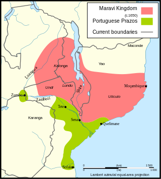
Maravi was a kingdom which straddled the current borders of Malawi, Mozambique, and Zambia, in the 16th century. The present-day name "Maláŵi" is said to derive from the Chewa word malaŵí, which means "flames". "Maravi" is a general name of the peoples of Malawi, eastern Zambia, and northeastern Mozambique. The Chewa language, which is also referred to as Nyanja, Chinyanja or Chichewa, and is spoken in southern and central Malawi, in Zambia and to some extent in Mozambique, is the main language that emerged from this empire.
Dedza is a district in the Central Region of Malawi. It covers an area of 3,624 km.² to the south of the Malawi capital, Lilongwe, between Mozambique and Lake Malawi. The capital is Dedza.
Likoma District is the least populous district of Malawi, which consists of two separate exclaves of Malawi situated within Mozambican waters in Lake Malawi. It consists of two main islands, Likoma and Chizumulu. It is a district in the Northern Region of Malawi. The capital is Likoma.
Nsanje is a district in the Southern Region of Malawi. The capital is Nsanje. The district covers an area of 1,942 square kilometres (750 sq mi) and has a population of 194,924.
The Chewa are a Bantu ethnic group found in Malawi, Zambia and few in Mozambique. The Chewa are closely related to people in surrounding regions such as the Tumbuka and Nsenga. They are historically also related to the Bemba, with whom they share a similar origin in the Democratic Republic of the Congo. As with the Nsenga and Tumbuka, a small part of Chewa territory came under the influence of the Ngoni, who were of Zulu or Natal/Transvaal origin. An alternative name, often used interchangeably with Chewa, is Nyanja. Their language is called Chichewa. Internationally, the Chewa are mainly known for their masks and their secret societies, called Nyau, as well as their agricultural techniques.
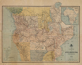
The Pink Map, also known in English as the Rose-Coloured Map, was a map prepared in 1885 to represent Portugal's claim of sovereignty over a land corridor connecting their colonies of Angola and Mozambique during the Scramble for Africa. The area claimed included most of what is currently Zimbabwe and large parts of modern Zambia and Malawi. In the first half of the 19th century, Portugal fully controlled only a few coastal towns in Angola and Mozambique. It also claimed suzerainty over other almost independent towns and nominally Portuguese subjects in the Zambezi valley, but could rarely enforce its claims; most of the territory now within Angola and Mozambique was entirely independent of Portuguese control. Between 1840 and 1869, Portugal expanded the area it controlled but felt threatened by the activities of other powers.
MV Ilala, formally Ilala II, is a motor ferry that has plied Lake Malawi in East Africa since 1951. Every week she crosses the lake all the way north to Chilumba, Malawi, near Tanzania and then returns to Monkey Bay. She carries both passengers and freight, and calls at major towns on both the Malawian and Mozambican coast, as well as at two islands of the lake.
MV Chauncy Maples is a motor ship and former steamship that was launched in 1901 as SS Chauncy Maples. She spent her entire career on Lake Malawi and was regarded as the oldest ship afloat in Africa. After more than one hundred years' service it was intended to restore her for use as a floating medical clinic to support the several million lakeshore dwellers whose average life expectancy is 44 years. The Government of Malawi offered support for this in 2009 and charity fundraising was sufficient to make progress. The hull was found to be beyond repair at a viable cost so a more practical modern craft was proposed to give ambulance service around the lake.
William Percival Johnson was an Anglican missionary to Nyasaland. After education at Bedford School (1863–1873) and graduation from University College, Oxford, he went to Africa with the Universities' Mission to Central Africa, under the Bishop Edward Steere.
The Sena people are a Bantu ethnolinguistic group with origins in northwestern region of Mozambique, Sofala Province and Zambezia Province. They are also found in Malawi and Zimbabwe near their respective borders with Mozambique.
This page is based on this Wikipedia article Text is available under the CC BY-SA 4.0 license; additional terms may apply. Images, videos and audio are available under their respective licenses.