Lucera

Last updated • 6 min readFrom Wikipedia, The Free Encyclopedia
Lucera
Lucera-Stemma.svg
Map of comune of Lucera (province of Foggia, region Apulia, Italy).svg
Location of Lucera in the province of Foggia
Location of Lucera
Lucera
Italy provincial location map 2016.svg
Red pog.svg
Lucera
Location of Lucera in Italy
Italy Apulia location map.svg
Red pog.svg
Lucera
Lucera (Apulia)
Coordinates: 41°30′N15°20′E / 41.500°N 15.333°E / 41.500; 15.333
Country Italy
Region Flag of Apulia.svg  Apulia
Province Foggia (FG)
Government
  MayorGiuseppe Pitta (coalition of municipal lists)
Area
[1]
  Total
339.79 km2 (131.19 sq mi)
Elevation
[2]
219 m (719 ft)
Population
 (June 2012) [3]
  Total
34,243
Demonym Lucerini
Time zone UTC+1 (CET)
  Summer (DST) UTC+2 (CEST)
Postal code
71036
Dialing code 0881
Patron saint St Mary
Saint day16 August
Website Official website

Lucera (Lucerino: Lucére) is an Italian city of 34,243 inhabitants in the province of Foggia in the region of Apulia, and the seat of the Diocese of Lucera-Troia.

Contents

Located upon a flat knoll in the Tavoliere Plains, near the foot of Daunian Mountains, Lucera was the capital of Province of Capitanata and the County of Molise from 1579 until 1806.

Climate

The city is characterized by a Mediterranean climate, with long, hot summers, with extreme temperature changes during the day, and mild winters, although due to its proximity to the Daunian mountains the temperature can drop to values below 0 °C (32 °F). The winds are quite frequent and, although sometimes quite strong, are usually moderate.

The average annual temperature is around 15 °C (59 °F), and rainfall amounts to an average value of 497 millimetres (19.6 in). Snowfalls are rare.

Climate data for Lucera (1991–2020)
MonthJanFebMarAprMayJunJulAugSepOctNovDecYear
Mean daily maximum °C (°F)11.2
(52.2)
12.3
(54.1)
15.2
(59.4)
19.1
(66.4)
24.1
(75.4)
29.3
(84.7)
31.7
(89.1)
31.6
(88.9)
26.0
(78.8)
21.6
(70.9)
16.3
(61.3)
12.2
(54.0)
20.9
(69.6)
Daily mean °C (°F)8.5
(47.3)
9.1
(48.4)
11.6
(52.9)
14.9
(58.8)
19.5
(67.1)
24.4
(75.9)
26.9
(80.4)
26.8
(80.2)
21.9
(71.4)
17.9
(64.2)
13.3
(55.9)
9.6
(49.3)
17.0
(62.7)
Mean daily minimum °C (°F)5.7
(42.3)
5.9
(42.6)
7.9
(46.2)
10.7
(51.3)
14.9
(58.8)
19.5
(67.1)
22.0
(71.6)
22.1
(71.8)
17.9
(64.2)
14.2
(57.6)
10.3
(50.5)
7.0
(44.6)
13.2
(55.7)
Average precipitation mm (inches)42
(1.7)
41
(1.6)
43
(1.7)
36
(1.4)
37
(1.5)
36
(1.4)
26
(1.0)
27
(1.1)
46
(1.8)
53
(2.1)
53
(2.1)
57
(2.2)
497
(19.6)
Average relative humidity (%)80777471696561646874798172
Source 1: Istituto Superiore per la Protezione e la Ricerca Ambientale [4]
Source 2: Il Meteo (precipitation and humidity) [5]

History

Ancient era and early Middle Ages

Lucera is located in the territory of the ancient tribe of the Daunii. Archeological excavations show the presence of a Bronze Age village inside the city boundaries. Lucera was probably named after either Lucius, a mythical Daunian king, or a temple dedicated to the goddess Lux Cereris. A third possibility is that the city was founded and named by the Etruscans, in which case the name probably means Holy Wood (luc = "wood", eri = "holy").

In 321 BC, the Roman army was deceived into thinking Lucera was under siege by the Samnites. Hurrying to relieve their allies the army walked into an ambush and were defeated at the famous Battle of the Caudine Forks. The Samnites occupied Lucera but were thrown out after a revolt. The city sought Roman protection and in 320 BC was granted the status of Colonia Togata, which meant it was ruled by the Roman Senate. In order to strengthen the ties between the two cities, 2,500 Romans moved to Lucera. From then on, Lucera was known as a steadfast supporter of Rome.

During the civil wars of the late Republic, Pompey set up his headquarters in Lucera, but abandoned the city when Julius Caesar approached. Lucera quickly switched its allegiance and Caesar's clemency spared it from harm. In the next civil war between Octavian and Mark Anthony the city did not escape as lightly. After the war, Octavian settled many veteran soldiers on the lands of the ruined city. This helped Lucera recover quickly and marked an era of renewed prosperity. Many of the surviving Roman landmarks hail from this Augustan period, among them the Luceran amphitheatre.

With the fall of the Western Roman Empire the city of Lucera entered into a state of decline. In 663 AD, it was captured from the Lombards and destroyed by the Eastern Roman Emperor Constans II. A year later in 664 AD, the town was sacked by the Byzantine Empire to ward off Muslim expansion into southern Italy.

Islamic period

Lucera Cathedral was converted into a mosque during the brief Muslim settlement of Lucera. The Duomo of Lucera.jpg
Lucera Cathedral was converted into a mosque during the brief Muslim settlement of Lucera.

In 1224, Holy Roman Emperor Frederick II, responding to religious uprisings in Sicily, expelled all Muslims from the island, transferring many to Lucera (Lugêrah, as it was known in Arabic) over the next two decades. In this controlled environment, they could not challenge royal authority and they benefited the crown in taxes and military service. Their numbers eventually reached between 15,000 and 20,000, leading Lucera to be called Lucaera Saracenorum because it represented the last stronghold of Islamic presence in Italy. During peacetime, Muslims in Lucera were predominantly farmers. They grew durum wheat, barley, legumes, grapes and other fruits. Muslims also kept bees for honey. [6]

The colony thrived for 75 years until it was sacked in 1300 by Christian forces under the command of Giovanni Pippino di Barletta, with the acquiescence of Charles II of Naples. The majority of the city's Muslim inhabitants were slaughtered or – as happened to almost 10,000 of them – sold into slavery. [7] Their abandoned mosques were demolished, and churches were usually built in their place, including the cathedral of S. Maria della Vittoria. [8] The city and its history of this period find mention in the novel A Sultan in Palermo by Tariq Ali.

After the Muslims were removed from Lucera, Charles tried to settle Christians in the city. Those Muslims that converted to Christianity got part of their property back, but none was restored his former position of political or economic influence. As time progressed, grain production fell in the city, and in 1339 the city was hit by a famine. Christians were allowed to farm as the Muslims. [9]

Hohenstaufen castle. Lucera - Fortezza Svevo-Angioina di Lucera - 202209061905.jpg
Hohenstaufen castle.
Amphitheatre of Lucera. Amphitheatre of Lucera.jpg
Amphitheatre of Lucera.

Main sights

Sights in Lucera include:

Economy

The commune of Lucera is home to the Denominazione di origine controllata (DOC) wine of Cacc'e mmitte di Lucera. This red Italian wine is said to have gotten its name from the local dialect referring to the act of pouring a wine from cask to goblet and going back for seconds. The DOC includes 80 hectares (198 acres) of land around the commune with all grapes destined for DOC wine production needing to be harvested to a yield no greater than 14 tonnes/ha. The wine is made primarily (35-60%) from the Uva di Troia grape (known in Lucera under the synonym Sumarello), Montepulciano, Sangiovese and Malvasia nera (the latter three grapes collectively making up between 25-35% of the blend). White wine grape varieties are also permitted in this red wine with Trebbiano Toscano, Bombino bianco and Malvasia del Chianti collectively allowed to account for between 15-30% of the blend. The finished wine must attain a minimum alcohol level of 11.5% in order to be labelled with the Cacc'e mmitte di Lucera DOC designation. [10]

International relations

Twin towns – Sister cities

Lucera is twinned with:

See also

Related Research Articles

<span class="mw-page-title-main">Apulia</span> Region of Italy

Apulia, also known by its Italian name Puglia, is a region of Italy, located in the southern peninsular section of the country, bordering the Adriatic Sea to the east, the Strait of Otranto and Ionian Sea to the southeast and the Gulf of Taranto to the south. The region comprises 19,345 square kilometers (7,469 sq mi), and its population is about four million people. It is bordered by the other Italian regions of Molise to the north, Campania to the west, and Basilicata to the southwest. The regional capital is Bari.

<span class="mw-page-title-main">Malvasia</span> Variety of wine grape

Malvasia, also known as Malvazia, is a group of wine grape varieties grown historically in the Mediterranean region, Balearic Islands, Canary Islands and the island of Madeira, but now grown in many of the winemaking regions of the world. In the past, the names Malvasia, Malvazia, and Malmsey have been used interchangeably for Malvasia-based wines; however, in modern oenology, "Malmsey" is now used almost exclusively for a sweet variety of Madeira wine made from the Malvasia grape. Grape varieties in this family include Malvasia bianca, Malvasia di Schierano, Malvasia negra, Malvasia nera, Malvasia nera di Brindisi, Malvasia di Candia aromatica, Malvasia odorosissima, and a number of other varieties.

<span class="mw-page-title-main">Province of Foggia</span> Province of Italy

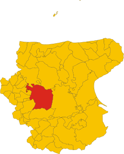
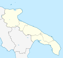
The province of Foggia is a province in the Italian region Apulia.

<span class="mw-page-title-main">Sabina (region)</span> Traditional region in Italy

Sabina, also called the Sabine Hills, is a region in central Italy. It is named after Sabina, the territory of the ancient Sabines, which was once bordered by Latium to the south, Picenum to the east, ancient Umbria to the north and Etruria to the west. It was separated from Umbria by the River Nar, today's Nera, and from Etruria by the River Tiber.

<span class="mw-page-title-main">Troia, Apulia</span> Comune in Apulia, Italy

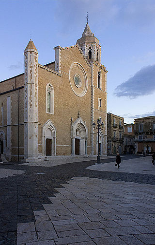
Troia is a town and comune in the province of Foggia and region of Apulia in southern Italy.

<span class="mw-page-title-main">Gravina in Puglia</span> Comune in Apulia, Italy

Gravina in Puglia is a town and comune of the Metropolitan City of Bari, Apulia, southern Italy.

<span class="mw-page-title-main">Bovino</span> Comune in Apulia, Italy

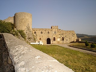
Bovino is a comune and hill town at the eastern side of the Apennines in the province of Foggia, Apulia, southern Italy.

Orta Nova is a town and comune about 25.4 kilometres (15.8 mi) from Foggia, in the region of Apulia, in southern Italy. It stretches to the southern part of the Tavoliere on the right bank of the river Carapelle.

San Paolo di Civitate is a town and comune in the province of Foggia in the Apulia region of south-east Italy. San Paolo di Civitate was historically an Arbëreshë settlement; the inhabitants, however, no longer use the Albanian language.

<span class="mw-page-title-main">Torremaggiore</span> Comune in Apulia, Italy

Torremaggiore is a town, comune (municipality) and former seat of a bishopric, in the province of Foggia in the Apulia, region of southeast Italy.

<span class="mw-page-title-main">Montepulciano (grape)</span> Variety of grape

Montepulciano is a red Italian wine grape variety that is most noted for being the primary grape behind the DOCG wines Colline Teramane Montepulciano d'Abruzzo and Offida Rosso; and the DOC wines Montepulciano d'Abruzzo, Rosso Conero, and Rosso Piceno Superiore.

<span class="mw-page-title-main">Uva di Troia</span> Variety of grape

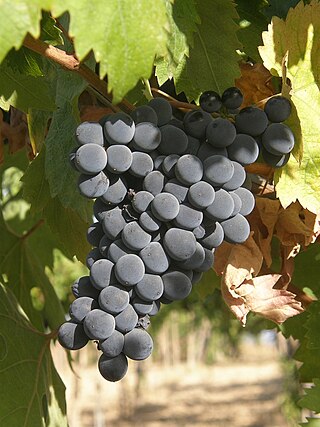
Uva di Troia is a red wine grape variety grown in the Italian region of Apulia, particularly in the areas around Andria and Barletta, and in the Province of Bari.

<span class="mw-page-title-main">Tavoliere delle Puglie</span> Plain in Southern Italy

The Tavoliere delle Puglie is a plain in northern Apulia, southern Italy, occupying nearly a half of the Capitanata traditional region. It covers a surface of c. 3,000 km2, once constituting a sea bottom: it is bounded by the Daunian Pre-Apennines on the West, the Gargano Promontory and the Adriatic Sea on the East, by the Fortore river on the north, and the Ofanto river on the south. It is the largest Italian plain after the Po Valley.

Greco is an Italian wine grape that may be of Greek origin. The name relates to both white and black grape varieties. While there is more land area dedicated to Greco nero, the Greco bianco is the grape most commonly referred to by "Greco". In the Campania region it is used to produce the denominazione di origine controllata e garantita (DOCG) wine Greco di Tufo. In Calabria, it is used to make the denominazione di origine controllata (DOC) wine Greco di Bianco. The name "Greco" is sometimes used as a synonym for several varieties of supposed Greek origins-most notably Trebbiano.

Verdeca is a white Italian wine grape variety that is primarily grown in Apulia in southern Italy where ampelographers believe that the grape may have originated. In Apulia, it is one of the main grapes in the Denominazione di origine controllata wines of Locorotondo DOC and Martina Franca DOC along with Bianco d'Alessano. In Campania, it is grown on the slopes of Mount Vesuvius where it used as a blending variety with Falanghina, Coda di volpe and Greco in both the white wines and the sweet dessert wine of the region, Lacryma Christi. It is also a minor component used in the some vermouth production.

<span class="mw-page-title-main">Bombino bianco</span> Variety of grape

Bombino bianco is a white Italian wine grape variety planted primarily along Italy's Adriatic coast line, most notably in Apulia. The vine is prone to high yields and often produces neutral flavor wines. The grape is known under many synonyms throughout Italy including Debit and Pagadebit, names which came from the grape's reputation for being a high yielding and reliable crop for vineyard owners to grow that would assure them that on each vintage they could pay off their debts.

<span class="mw-page-title-main">Daunians</span> Iapygian tribe which inhabited northern Apulia in classical antiquity

The Daunians were an Iapygian tribe that inhabited northern Apulia in classical antiquity. Two other Iapygian tribes, the Peucetians and the Messapians, inhabited central and southern Apulia respectively. All three tribes spoke the Messapic language, but had developed separate archaeological cultures by the seventh century BC.

<span class="mw-page-title-main">Muslim settlement of Lucera</span> Resettled Muslims of Sicily, 1220 to 1300

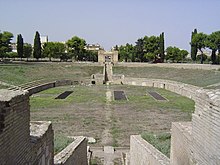
The Muslim settlement of Lucera was the result of the decision of the King of Sicily Frederick II of the Hohenstaufen dynasty (1194–1250) to move 20,000 Sicilian Muslims to Lucera, a settlement in Apulia in southern Italy. The settlement thrived for about 75 years. In 1300, it was captured by the Christian forces of Charles II of Naples and its Muslim inhabitants were exiled.

<span class="mw-page-title-main">Lucera Cathedral</span> Cathedral in Lucera, Italy

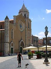
Lucera Cathedral is the cathedral of Lucera, Apulia, Italy. The dedication is to the Assumption of the Virgin Mary but it is also popularly known as Santa Maria della Vittoria from the statue of the Madonna kept here. It is the seat of the Bishop of Lucera-Troia, and is also a minor basilica. In its present form it originates mostly from the 14th century. It is one of the very few buildings in Apulia in which the Gothic architectural style of the medieval French rulers appears almost unaltered.

Troia may refer to:

References

  1. "Superficie di Comuni Province e Regioni italiane al 9 ottobre 2011". Italian National Institute of Statistics. Retrieved 16 March 2019.
  2. "Lucera". Tuttitalia (in Italian).
  3. Population data from Istat
  4. "Valori climatici normali in Italia". Istituto Superiore per la Protezione e la Ricerca Ambientale. Archived from the original on 17 September 2023. Retrieved 11 December 2024.
  5. "Clima Lucera - Medie climatiche" (in Italian). ilmeteo.it. Retrieved 11 December 2024.
  6. Taylor, p.99
  7. Julie Taylor. Muslims in Medieval Italy: The Colony at Lucera. Lanham, Md.: Lexington Books. 2003. [ dead link ]
  8. Taylor, p.187
  9. Taylor, pp. 190-194
  10. P. Saunders Wine Label Language pg 131 Firefly Books 2004 ISBN   1-55297-720-X

Sources