Vico del Gargano

Last updated
Vico del Gargano
Comune di Vico del Gargano
Vico del Gargano panorama.jpg
Location of Vico del Gargano
Vico del Gargano
Italy provincial location map 2016.svg
Red pog.svg
Vico del Gargano
Location of Vico del Gargano in Italy
Italy Apulia location map.svg
Red pog.svg
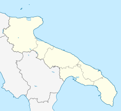
Vico del Gargano
Vico del Gargano (Apulia)
Coordinates: 41°54′N15°58′E / 41.900°N 15.967°E / 41.900; 15.967
Country Italy
Region Apulia
Province Foggia (FG)
Frazioni San Menaio
Government
  MayorMichele Sementino
Area
[1]
  Total110.53 km2 (42.68 sq mi)
Elevation
462 m (1,516 ft)
Population
 (28 February 2017) [2]
  Total7,712
  Density70/km2 (180/sq mi)
Demonym Vichesi
Time zone UTC+1 (CET)
  Summer (DST) UTC+2 (CEST)
Postal code
71018
Dialing code 0884
Patron saint Saint Valentine
Saint day14 February
Website Official website

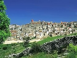
Vico del Gargano is a village and comune in the province of Foggia in the Apulia region of southeast Italy. Called the "Village of Love", it is part of the Gargano National Park and the Mountain Community of Gargano.

Contents

The town is bordered by Carpino, Ischitella, Monte Sant'Angelo, Peschici, Rodi Garganico and Vieste. It is one of I Borghi più belli d'Italia ("The most beautiful villages of Italy"). [3]

Geography

The municipality of Vico del Gargano is located in the northeast part of the Gargano Promontory, covering an area of 110.4 km². The area has an extensive range of altitudes, from 0 to 782 meters above sea level, spanning from the submontane heights of the Umbra Forest to the beaches of San Menaio and Calenella. The inland landscape is characterized by beech and fir woods, while the coast is dominated by Aleppo pine forests, including the Pineta Marzini. On the coast, there are widespread centuries-old olive groves and terraced citrus groves. The geology of the area is primarily karst, with numerous caves, including marine ones.

Vico del Gargano is the heart of the Gargano National Park and encompasses most of the Umbra Forest within its territory.

Seismicity

The entire municipal territory of Vico del Gargano is part of the seismic district of the Gargano, with a seismic classification of "zone 2" (medium seismicity).

Main sights

Sights include:

Twin towns

Related Research Articles

<span class="mw-page-title-main">Geography of Italy</span> Geographical features of Italy

The geography of Italy includes the description of all the physical geographical elements of Italy. Italy, whose territory largely coincides with the homonymous geographical region, is located in southern Europe and comprises the long, boot-shaped Italian Peninsula crossed by the Apennines, the southern side of Alps, the large plain of the Po Valley and some islands including Sicily and Sardinia. Italy is part of the Northern Hemisphere. Two of the Pelagie Islands are located on the African continent.

Frosinone is a comune (municipality) in the Italian region of Lazio, administrative seat of the province of Frosinone. It is located about 75 kilometres (47 mi) southeast of Rome, close to the Rome-Naples A1 Motorway. The city is the main city of the Valle Latina, an Italian geographical and historical region that extends from south of Rome to Cassino.

<span class="mw-page-title-main">Province of Foggia</span> Province of Italy

The province of Foggia is a province in the Apulia region of Italy.

<span class="mw-page-title-main">Manfredonia</span> Comune in Apulia, Italy

Manfredonia is a town and commune of Apulia, Italy, in the province of Foggia, from which it is 35 kilometres northeast by rail. Manfredonia is situated on the coast, facing east, to the south of Monte Gargano, and gives its name to the gulf to the east of it. As of 2017 its population was 56,932.

<span class="mw-page-title-main">Gargano</span> Historical and geographical region of Italy

Gargano (Italian:[ɡarˈɡaːno], is a historical and geographical sub-region in the province of Foggia, Apulia, southeast Italy, consisting of a wide isolated mountain massif made of highland and several peaks and forming the backbone of the Gargano Promontory projecting into the Adriatic Sea, the "spur" on the Italian "boot".

<span class="mw-page-title-main">Pretoro</span> Comune in Abruzzo, Italy

Pretoro is a town of about 1,100 inhabitants situated in Majella National Park, in the province of Chieti, Abruzzo, southern Italy. It is located on a steep hillside on the eastern side of the Maiella mountains. Its proximity to Passo Lanciano-La Majelletta ski area, guarantees the availability of winter sports, while the town is also only 20 minutes by car from the Adriatic Sea. It is one of I Borghi più belli d'Italia.

<span class="mw-page-title-main">Bagni di Lucca</span> Comune in Tuscany, Italy

Bagni di Lucca is a comune of Tuscany, Italy, in the Province of Lucca with a population of about 6,100. The comune has 27 named frazioni (wards).

<span class="mw-page-title-main">Civitella Casanova</span> Comune in Abruzzo, Italy

Civitella Casanova is an Italian town of inland mountain of 1,950 inhabitants in the province of Pescara in Abruzzo and belongs to the mountain community Vestina. Listed on the National Park of Gran Sasso and Monti della Laga and the Regional Reserve Voltigno and Valle d'Angri, a regional reserve included in the National Park, the country bases its economy mainly on agriculture. It has pre-Roman origins of repute, the sources of the historian Livy emerges as the town of Civitella was called Cutina or Cingilia.

<span class="mw-page-title-main">Albanella</span> Comune in Campania, Italy

Albanella is a town and comune in the province of Salerno in the Campania region of south-western Italy. It is located 51 kilometers from the city of Salerno.

<span class="mw-page-title-main">Rodi Garganico</span> Comune in Apulia, Italy

Rodi Garganico is a town and commune in the province of Foggia, Apulia, south-eastern Italy. Located on a promontory east of the Lago di Varano, it is part of the Gargano National Park and of the Mountain Community of Gargano.

<span class="mw-page-title-main">Peschici</span> Comune in Apulia, Italy

PeschiciItalian pronunciation:[ˈpɛskitʃi] is a town and comune in the province of Foggia in the Apulia region of southeast Italy. Famous for its seaside resorts, its territory belongs to the Gargano National Park and to the Gargano Mountain Community.

<span class="mw-page-title-main">Vieste</span> Comune in Apulia, Italy

Vieste is a town, comune and former Catholic bishopric in the province of Foggia, in the Apulia region of southeast Italy. A marine resort in Gargano, Vieste has received Blue Flags for the purity of its waters from the Foundation for Environmental Education. The area covered by the comune is included in the Gargano National Park.

<span class="mw-page-title-main">Maruggio</span> Comune in Apulia, Italy

Maruggio is a village and comune in the province of Taranto, Apulia, southeast Italy. The village is located in a natural depression 2 kilometres (1.2 mi) from the Gulf of Taranto, in the north-west part of Salento peninsula and it's one of the villages of South Italy where the Greek dialect Griko is spoken.

<span class="mw-page-title-main">Cirié</span> Comune in Piedmont, Italy

Cirié is a comune (municipality) in the Metropolitan City of Turin in the Italian region Piedmont, located about 20 kilometres (12 mi) northwest of Turin.

<span class="mw-page-title-main">Levanto, Liguria</span> Comune in Liguria, Italy

Levanto is a comune (municipality) in the province of La Spezia, in the Italian region of Liguria, located almost 90 kilometres (56 mi) southeast of Genoa and about 20 kilometres (12 mi) northwest of La Spezia.

<span class="mw-page-title-main">Scheggino</span> Comune in Umbria, Italy

Scheggino is a comune (municipality) in the Province of Perugia in the Italian region Umbria, located about 60 km southeast of Perugia. As of January 2020, it had a population of 464 and an area of 35.2 km².

<span class="mw-page-title-main">Capranica, Lazio</span> Comune in Lazio, Italy

Capranica is a comune (municipality) in the Province of Viterbo in the Italian region Lazio, located about 55 kilometres (34 mi) northwest of GRA, 66 kilometres (41 mi) from Rome’s centre, and 24.5 kilometres (15.2 mi) southeast of Viterbo.

<span class="mw-page-title-main">San Menaio</span> Frazione in Apulia, Italy

San Menaio, also San Menaio Garganico, is a small village and seaside resort, a frazione of the comune of Vico del Gargano in the province of Foggia and the Apulia region of south-east Italy. The 2001 census counted a resident population of 193 living in 97 family units.

<i>Trabucco</i>

The trabucco or trabocco, in some southern dialects called travocc, is an old fishing machine typical of the Adriatic coast of Abruzzo and also in the coast of Gargano, where they are protected as historical monuments in the Gargano National Park. Trabucchi are spread along the coast of the southern Adriatic, especially in the Italian provinces of Chieti, Campobasso, and Foggia, and also in some parts of the coast of the southern Tyrrhenian Sea.

<span class="mw-page-title-main">Gargano National Park</span> National park in Foggia, Italy

The Gargano National Park is a national park in the province of Foggia in southern Italy. Aside from the Gargano promontory from which it takes its name, it includes also the Tremiti Islands archipelago and the wetlands Lago Salso. It is the largest park in Apulia.

References

  1. "Superficie di Comuni Province e Regioni italiane al 9 ottobre 2011". Italian National Institute of Statistics. Retrieved 16 March 2019.
  2. All demographics and other statistics from the Italian statistical institute (Istat)
  3. "Puglia" (in Italian). Retrieved 1 August 2023.