Centerville, Minnesota

Last updated

Centerville
Motto: 
"Fete Des Lacs" Festival Of Lakes
Anoka Cnty Minnesota Incorporated and Unincorporated areas Centerville Highlighted copy.png
Location of the city of Centerville
within Anoka County, Minnesota
Coordinates: 45°09′50″N93°03′15″W / 45.16389°N 93.05417°W / 45.16389; -93.05417
CountryUnited States
State Minnesota
County Anoka
Established1857
Incorporated September 27, 1910
Area
[1]
  Total2.43 sq mi (6.28 km2)
  Land2.13 sq mi (5.50 km2)
  Water0.30 sq mi (0.78 km2)
Elevation
[2]
909 ft (277 m)
Population
 (2020) [3]
  Total3,896
  Estimate 
(2022) [4]
3,932
  Density1,833.41/sq mi (707.79/km2)
Time zone UTC-6 (Central (CST))
  Summer (DST) UTC-5 (CDT)
ZIP code
55038
Area code 651
FIPS code 27-10648 [5]
GNIS feature ID2393784 [2]

Centerville is a city in Anoka County, Minnesota, United States. The population was 3,896 at the 2020 census. [3]

Contents

Geography

According to the United States Census Bureau, the city has a total area of 2.41 square miles (6.24 km2), of which 2.13 square miles (5.52 km2) is land and 0.28 square miles (0.73 km2) is water. [6]

Main Street / County Road 14 serves as a main route in the community. Interstate 35E is nearby.

Centerville is completely surrounded by the city of Lino Lakes.

History

Centerville was established in 1857. [7] It was named for its location in relation to Saint Paul, the Mississippi River at Anoka, and the Saint Croix River at Stillwater. [8]

Education

Centerville is served by Independent School District #12, the Centennial School District. Students attend Centerville Elementary School from kindergarten to 5th grade, Centennial Middle School in Lino Lakes from sixth to eighth grade, and Centennial High School in nearby Circle Pines from ninth to 12th grade.

Demographics

Historical population
CensusPop.Note
1880 130
1920 209
1930 196−6.2%
1940 195−0.5%
1950 2097.2%
1960 33861.7%
1970 53458.0%
1980 73437.5%
1990 1,633122.5%
2000 3,20296.1%
2010 3,79218.4%
2020 3,8962.7%
2022 (est.)3,932 [4] 0.9%
U.S. Decennial Census [9]
2020 Census [3]

2010 census

As of the census of 2010, there were 3,792 people, 1,315 households, and 1,025 families living in the city. The population density was 1,780.3 inhabitants per square mile (687.4/km2). There were 1,363 housing units at an average density of 639.9 per square mile (247.1/km2). The racial makeup of the city was 94.3% White, 0.3% African American, 0.4% Native American, 2.7% Asian, 0.4% from other races, and 1.8% from two or more races. Hispanic or Latino of any race were 1.6% of the population.

There were 1,315 households, of which 46.6% had children under the age of 18 living with them, 67.8% were married couples living together, 5.9% had a female householder with no husband present, 4.3% had a male householder with no wife present, and 22.1% were non-families. 17.6% of all households were made up of individuals, and 5.6% had someone living alone who was 65 years of age or older. The average household size was 2.88 and the average family size was 3.28.

The median age in the city was 35.8 years. 30.8% of residents were under the age of 18; 6% were between the ages of 18 and 24; 29.9% were from 25 to 44; 25.9% were from 45 to 64; and 7.4% were 65 years of age or older. The gender makeup of the city was 50.8% male and 49.2% female.

2000 census

As of the census of 2000, there were 3,206 people, 1,078 households, and 879 families living in the city. The population density was 1,486.5 inhabitants per square mile (573.9/km2). There were 1,094 housing units at an average density of 507.9 per square mile (196.1/km2) The racial makeup of the city was 96.72% White, 0.25% African American, 0.44% Native American, 0.72% Asian, 0.37% from other races, and 1.50% from two or more races. Hispanic or Latino of any race were 1.44% of the population.

There were 1,078 households, out of which 50.3% had children under the age of 18 living with them, 72.8% were married couples living together, 5.9% had a female householder with no husband present, and 18.4% were non-families. 13.6% of all households were made up of individuals, and 1.8% had someone living alone who was 65 years of age or older. The average household size was 2.97 and the average family size was 3.28.

In the city, the population was spread out, with 33.6% under the age of 18, 5.1% from 18 to 24, 42.8% from 25 to 44, 15.2% from 45 to 64, and 3.3% who were 65 years of age or older. The median age was 31 years. For every 100 females, there were 105.9 males. For every 100 females age 18 and over, there were 104.3 males.

The median income for a household in the city was $63,696, and the median income for a family was $67,336. Males had a median income of $42,371 versus $31,474 for females. The per capita income for the city was $23,113. About 0.6% of families and 2.4% of the population were below the poverty line, including 0.7% of those under age 18 and none of those age 65 or over.

Notable person

Related Research Articles

<span class="mw-page-title-main">Melba, Idaho</span> Village in Idaho, United States

Melba is a village in Canyon County, Idaho. The population was 513 at the time of the 2010 census, up from 439 in 2000. It is part of the Boise metropolitan area.

<span class="mw-page-title-main">Exline, Iowa</span> City in Iowa, USA

Exline is a city in Appanoose County, Iowa, United States. The population was 160 in the 2020 census, a decline from 191 in 2000.

<span class="mw-page-title-main">Numa, Iowa</span> City in Iowa, USA

Numa is a city in Appanoose County, Iowa, United States. The population was 68 in the 2020 census, a decline from 109 in 2000.

<span class="mw-page-title-main">Brooks, Maine</span> Town in the state of Maine, United States

Brooks is a town in Waldo County, Maine, United States. The population was 1,010 at the 2020 census.

<span class="mw-page-title-main">Anoka, Minnesota</span> City in Minnesota, United States

Anoka is a city in and the county seat of Anoka County, Minnesota, United States. Its population was 17,142 at the 2010 census. Anoka is the "Halloween Capital of the World" because it hosted one of the first Halloween parades in 1920. It continues to celebrate the holiday each year with several parades. Anoka is a northern suburb of the Twin Cities. U.S. Highways 10 / 169 and State Highway 47 are three of Anoka's main routes, and it has a station on the Northstar Commuter Rail line to Minneapolis.

<span class="mw-page-title-main">East Bethel, Minnesota</span> City in Minnesota, United States

East Bethel is a city in Anoka County, Minnesota, United States. The population was 11,786 at the 2020 census.

<span class="mw-page-title-main">Watertown, Minnesota</span> City in Minnesota, United States

Watertown is a small city in Carver County, Minnesota, United States, along the South Fork of the Crow River, on the outskirts of the Twin Cities metro area. The population was 4,659 at the 2020 census.

<span class="mw-page-title-main">Pilot Knob, Missouri</span> City in Missouri, United States

Pilot Knob is a city in northeast Iron County, Missouri, United States. The population was 671 at the 2020 census. It lies eighteen miles south-east of Belgrade and twenty-seven miles north-east of Centerville.

<span class="mw-page-title-main">Centerville, Missouri</span> City in Missouri, United States

Centerville is a city in Reynolds County, Missouri, United States, situated along the West Fork of the Black River. The population was 167 at the 2020 census. It is the county seat of Reynolds County.

<span class="mw-page-title-main">Innsbrook, Missouri</span> Village in Missouri, United States

Innsbrook is a village in Warren County, Missouri, United States. The population was 552 at the 2010 census. The village of Innsbrook is comprised almost entirely by Innsbrook Resort—a private, gated community. The village was founded in 1998.

<span class="mw-page-title-main">Centerville, Gallia County, Ohio</span> Village in Ohio, United States

Centerville, also known as Thurman, is a village in Gallia County, Ohio, United States. The population was 87 at the 2020 census. It is part of the rural Point Pleasant micropolitan area. It is located near U.S. Route 35 near the eastern terminus of State Route 279 as the highways parallel each other for about 1/2 mile.

<span class="mw-page-title-main">Centerville, Ohio</span> City in Ohio, United States

Centerville is a city in Montgomery County, Ohio, United States. A core suburb of Metro Dayton, its population was 24,240 as of the 2020 census.

<span class="mw-page-title-main">Centerville, Washington County, Pennsylvania</span> Borough in Washington County, Pennsylvania, United States

Centerville is a borough in Washington County, Pennsylvania, United States. The population was 3,254 at the 2020 census.

<span class="mw-page-title-main">Centerville, South Carolina</span> CDP in South Carolina, United States

Centerville is a census-designated place (CDP) in Anderson County, South Carolina. The population was 7,185 at the 2020 census.

<span class="mw-page-title-main">Centerville, South Dakota</span> City in South Dakota, United States

Centerville is a city in Turner County, South Dakota, United States. The population was 918 at the 2020 census. Centerville is part of the Sioux Falls, South Dakota metropolitan area.

Pine Crest is a census-designated place (CDP) in Carter County, Tennessee, United States. The population was 2,388 at the 2010 census. It is part of the Johnson City Metropolitan Statistical Area, which is a component of the Johnson City–Kingsport–Bristol, TN-VA Combined Statistical Area – commonly known as the "Tri-Cities" region.

<span class="mw-page-title-main">Centerville, Washington</span> Census-designated place in Washington, United States

Centerville is an unincorporated community and census-designated place (CDP) in Klickitat County, Washington, United States. Settled in 1877 by Albert J. Brown, the population was 112 at the 2010 census.

<span class="mw-page-title-main">Fall Creek, Wisconsin</span> Village in Wisconsin, United States

Fall Creek is a village in Eau Claire County, Wisconsin, United States. The population was 1,315 at the 2010 census. The village is bordered by the Town of Lincoln.

<span class="mw-page-title-main">Centerville, Manitowoc County, Wisconsin</span> Town in Wisconsin, United States

Centerville is a town in Manitowoc County, Wisconsin, United States. The population was 713 at the 2000 census. The town is divided by I-43 and surrounds the Village of Cleveland.
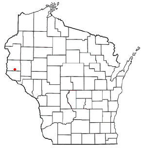
<span class="mw-page-title-main">Fairfield, Wisconsin</span> Town in Wisconsin, United States

The Town of Fairfield is located in Sauk County, Wisconsin, United States. The population was 1,078 at the 2020 census. The unincorporated community of Greens Corners is located in the town.

References

  1. "2020 U.S. Gazetteer Files". United States Census Bureau. Retrieved July 24, 2022.
  2. 1 2 U.S. Geological Survey Geographic Names Information System: Centerville, Minnesota
  3. 1 2 3 "Explore Census Data". United States Census Bureau . Retrieved October 12, 2023.
  4. 1 2 "City and Town Population Totals: 2020-2022". United States Census Bureau. October 12, 2023. Retrieved October 12, 2023.
  5. "U.S. Census website". United States Census Bureau . Retrieved January 31, 2008.
  6. "US Gazetteer files 2010". United States Census Bureau. Archived from the original on January 25, 2012. Retrieved November 13, 2012.
  7. "City of Centerville". City of Centerville. Retrieved June 30, 2012.
  8. "Profile for Centerville, Minnesota, MN". ePodunk. Retrieved June 30, 2012.
  9. United States Census Bureau. "Census of Population and Housing" . Retrieved October 28, 2014.
  10. Serrano, Richard A. "Gulf War Veteran Executed for 1995 Murder." Los Angeles Times . March 19, 2003. Retrieved on July 17, 2016.